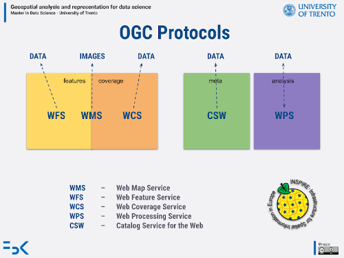
Lesson 07
Basic operations on raster data
based on rasterio goals of the tutorial
- manage raster data
- manipulate raster with vector data
based on the open data of:
- orthophotos of Municipality of Trento
- DTM - Autonomous Province of Trento
requirements
- python knowledge
- geopandas
status
the world in a matrix
Introduction

small summary: view the slides from the page 11 until 19

Setup
try:
  import geopandas as gpd
except ModuleNotFoundError as e:
  !pip install geopandas==0.12.1
  import geopandas as gpd

if gpd.__version__ != "0.12.1":
  !pip install -U geopandas==0.12.1
  import geopandas as gpd
try:
  import rasterio as rio
except ModuleNotFoundError as e:
  !pip install rasterio==1.3.4
  import rasterio as rio

if rio.__version__ != "1.3.4":
  !pip install -U rasterio==1.3.4
  import rasterio as rio
try:
  import owslib
except ModuleNotFoundError as e:
  !pip install owslib==0.25.0
  import owslib

if owslib.__version__ != "0.25.0":
  !pip install -U owslib==0.25.0
  import owslib
import warnings
warnings.simplefilter("ignore")
import matplotlib.pyplot as plt
Data resources
you can find data on all geospatial infrastructures through various protocols
Here you will find the most popular resources
DEM
- TiniTtaly DEM
- SRTM - download
- ASTER Global Digital Elevation
Satellite Images
- Copernicus
- Planet (no opendata)
- Maxar (no opendata)
Data
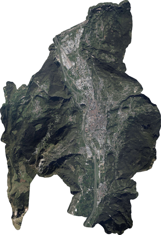
Orthophoto of Trento 2019
https://www.comune.trento.it/Aree-tematiche/Cartografia/Download/Ortofoto-2019
- data acquisition: 3th October 2019
- scale 1:2.000
- resolution 1px = 10cm
- tiff file size 3,5Gb
- crs ETRS89 / UTM zone 32N - EPSG:25832
- tfw file
… file too big for our purpose
The municipality of Trento offers also a WMS service
Please check the lesson “Retrieving data from spatial database infrastructures”
The end point of the WMS is http://webapps.comune.trento.it/ogc
from owslib.wms import WebMapService
wms_trento = "http://webapps.comune.trento.it/ogc"
wms = WebMapService(wms_trento)
list(wms.contents)
['ogc_services',
 'ortofoto2009',
 'ortofoto2015',
 'ortofoto2016',
 'ortofoto2019',
 'ortofoto2015aldeno',
 'ortofoto2016infrarosso',
 'ortofoto2019infrarosso',
 'ct2000',
 'ct2000_colori',
 'carta_semplificata',
 'ombreDTM',
 'ombreDSM',
 'toponomastica',
 'grafo',
 'civici',
 'civici_principali',
 'toponimi',
 'prg_vigente',
 'pric']
wms['ortofoto2019'].crsOptions
['EPSG:4326', 'EPSG:3857', 'EPSG:25832']
wms['ortofoto2019'].boundingBox
(637271.0, 5083800.0, 684982.0, 5119620.0, 'EPSG:25832')
request = wms.getmap(
    layers=['ortofoto2019'],
    srs='EPSG:25832',
    format='image/jpeg',
    bbox=(648300.0, 5090700.0, 677500.0, 5116000.0),
    size=(833,606)
    )
from rasterio import MemoryFile
from rasterio.plot import show
image = MemoryFile(request).open()
show(image)
plt.show()
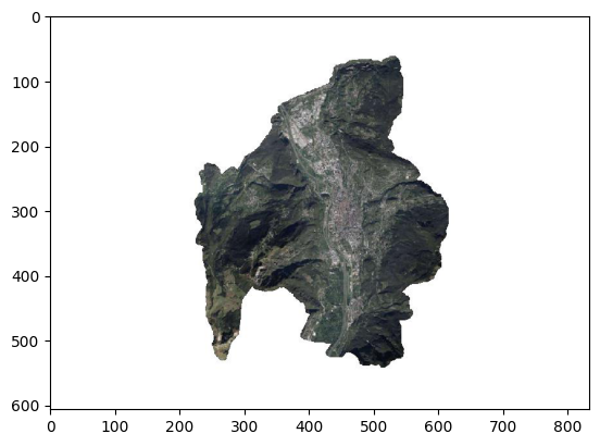
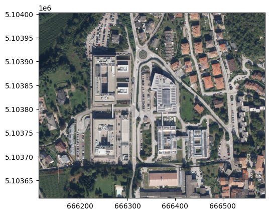
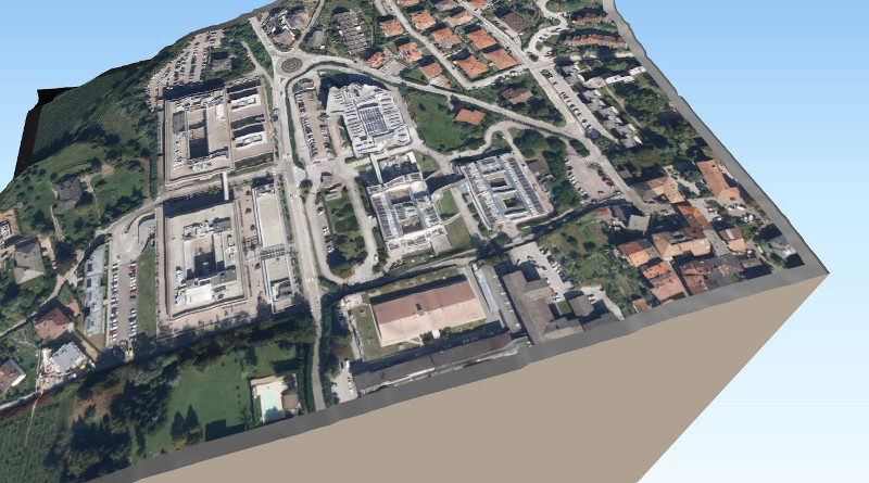
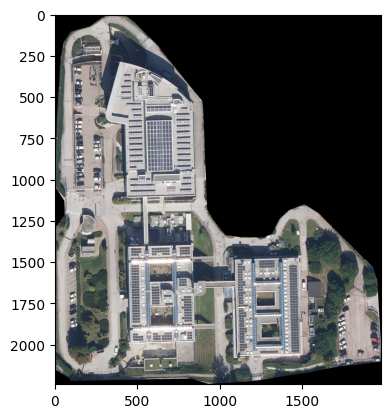
Manage a raster
Here you can find a cutted version of the geotiff of the muncipality of Trento around the scientific hub area in Povo - Trento
(where the lessons of this course are held)
investigate an orthophoto
import urllib.request
url_download_orthophoto_scientific_hub_povo = 'https://github.com/napo/geospatial_course_unitn/raw/master/data/raster/trento_scientifc_hub_povo.tif'
file_scientific_hub_povo = "trento_scientifc_hub_povo.tif"
urllib.request.urlretrieve(url_download_orthophoto_scientific_hub_povo ,file_scientific_hub_povo)
('trento_scientifc_hub_povo.tif', <http.client.HTTPMessage at 0x7f8fe2516740>)
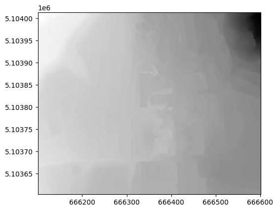
raster = rio.open(file_scientific_hub_povo)
show(raster)

<AxesSubplot:>
dimension of the image in pixel
raster.width
4761
raster.height
3900
raster.crs
CRS.from_epsg(25832)
raster.res
(0.09999999999999999, 0.09999999999999999)
raster.bounds
BoundingBox(left=666113.0, bottom=5103613.0, right=666589.1, top=5104003.0)
raster.meta
{'driver': 'GTiff',
 'dtype': 'uint8',
 'nodata': None,
 'width': 4761,
 'height': 3900,
 'count': 3,
 'crs': CRS.from_epsg(25832),
 'transform': Affine(0.09999999999999999, 0.0, 666113.0,
        0.0, -0.09999999999999999, 5104003.0)}
raster.count
3
raster.indexes # the values start from 1 !
(1, 2, 3)
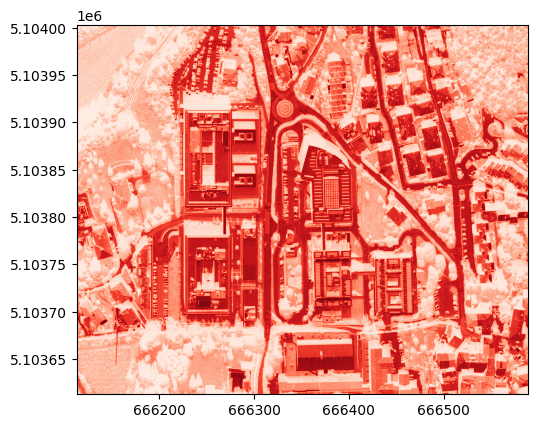
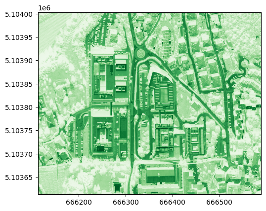
show((raster, 1), cmap='Reds')
<AxesSubplot:>
show((raster, 2), cmap='Greens')
<AxesSubplot:>
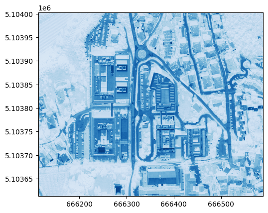
show((raster, 3), cmap='Blues')
<AxesSubplot:>
raster.colorinterp[0]
<ColorInterp.red: 3>
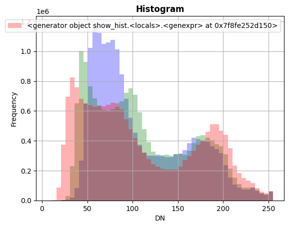
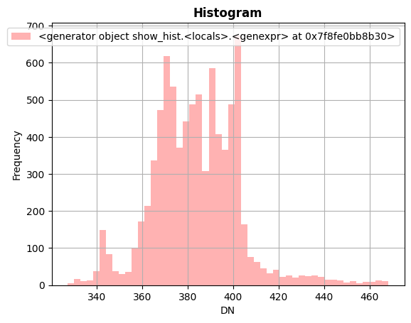
from rasterio.plot import show_hist
show_hist(raster, bins=50, lw=0.0, stacked=False, alpha=0.3,histtype='stepfilled', title="Histogram")
investigate an DTM file
url_download_dtm_scientific_hub_povo = 'https://github.com/napo/geospatial_course_unitn/raw/master/data/raster/trento_scientifc_hub_povo_dtm.asc'
dtm = "trento_scientifc_hub_povo_dtm.asc"
urllib.request.urlretrieve(url_download_dtm_scientific_hub_povo ,dtm)
('trento_scientifc_hub_povo_dtm.asc',
 <http.client.HTTPMessage at 0x7f8fe48764d0>)
url_download_dtm_scientific_hub_povo_prj = 'https://github.com/napo/geospatial_course_unitn/raw/master/data/raster/trento_scientifc_hub_povo_dtm.prj'
dtm_prj = "trento_scientifc_hub_povo_dtm.prj"
urllib.request.urlretrieve(url_download_dtm_scientific_hub_povo_prj ,dtm_prj)
('trento_scientifc_hub_povo_dtm.prj',
 <http.client.HTTPMessage at 0x7f8fe4822140>)
dtm = "trento_scientifc_hub_povo_dtm.asc"
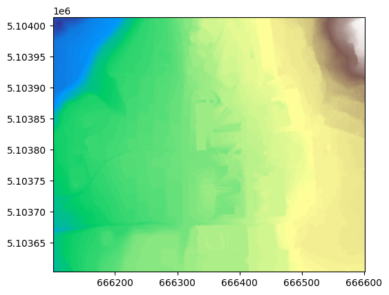
raster_dtm = rio.open(dtm)
show(raster_dtm)
<AxesSubplot:>
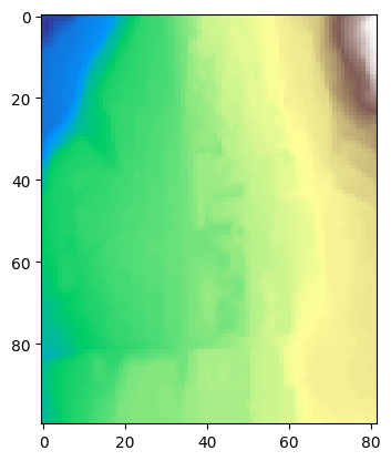
show(raster_dtm,cmap="Greys")
<AxesSubplot:>
raster_dtm.crs
CRS.from_epsg(25832)
raster_dtm.meta
{'driver': 'AAIGrid',
 'dtype': 'float32',
 'nodata': None,
 'width': 500,
 'height': 410,
 'count': 1,
 'crs': CRS.from_epsg(25832),
 'transform': Affine(1.0, 0.0, 666100.6735466761,
        0.0, -1.0, 5104013.23583161)}
raster_dtm.res
(1.0, 1.0)
raster_dtm.count
1
show(raster_dtm, cmap='terrain')
<AxesSubplot:>
show(raster)
<AxesSubplot:>
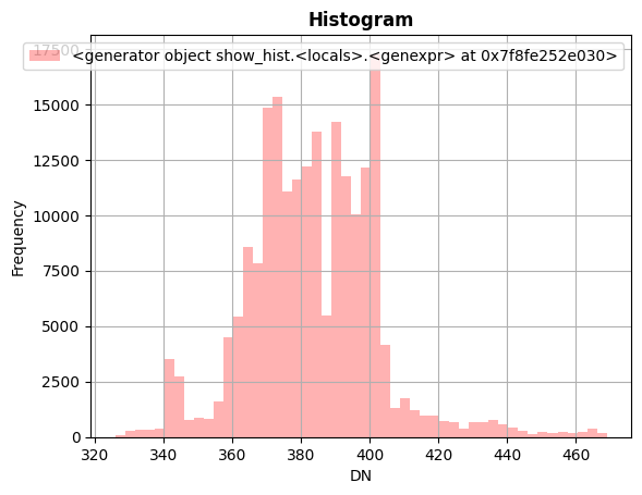
show_hist(raster_dtm, bins=50, lw=0.0, stacked=False, alpha=0.3,histtype='stepfilled', title="Histogram")
data = raster_dtm.read(1)
type(data)
numpy.ndarray
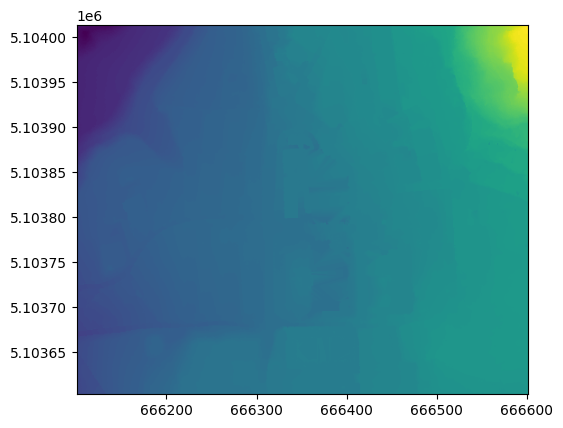
Which altitude is?
this image is generated with QGIS and the plugin qgis2threejs
data.mean()
383.85464
data.min()
326.0
data.max()
469.0
find the value on a given point
Example:
the position of “Via Sommarive 18, Trento” (the address of FBK)
import shapely
import pyproj
from geopy.geocoders import Nominatim
from shapely.ops import transform
… identify the point wiht a geocoder
geolocator = Nominatim(user_agent="geospatial course")
location = geolocator.geocode("Via Sommarive 18, Trento")
x = location.longitude
y = location.latitude
y
46.06692965
transform the coordinate from EPSG 4326 to 25832
wgs84 = pyproj.CRS('EPSG:4326')
crs_dtm = pyproj.CRS('EPSG:25832')
projection_transform = pyproj.Transformer.from_crs(wgs84, crs_dtm, always_xy=False).transform
point_location = shapely.geometry.Point(y,x)
point_location_crs_dtm = transform(projection_transform,point_location)
x = point_location_crs_dtm.x
y = point_location_crs_dtm.y
y
5103733.953099297
row,col = rio.transform.rowcol(raster_dtm.transform,(x),(y))
col
282
Identify the value
data[row][col]
381.0
Resampling
Downsampling to 1/5 of the resolution can be done withupscale_factor = 1/5
raster_dtm.profile
{'driver': 'AAIGrid', 'dtype': 'float32', 'nodata': None, 'width': 500, 'height': 410, 'count': 1, 'crs': CRS.from_epsg(25832), 'transform': Affine(1.0, 0.0, 666100.6735466761,
       0.0, -1.0, 5104013.23583161), 'blockysize': 1, 'tiled': False}
from rasterio.enums import Resampling

upscale_factor = 1/5

# resample data to target shape
data_s = raster_dtm.read(
        out_shape=(
            raster_dtm.count,
            int(raster_dtm.width * upscale_factor),
            int(raster_dtm.height * upscale_factor)
        ),
        resampling=Resampling.bilinear
    )
profile =raster_dtm.profile
profile.update(dtype=rio.uint8, count=1, compress='lzw')

with rio.open('resampled_area.tif', 'w', **profile) as dst:
  dst.write(data_s.astype(rio.uint8))
Warning 6: driver AAIGrid does not support creation option BLOCKYSIZE
Warning 6: driver AAIGrid does not support creation option TILED
Warning 6: driver AAIGrid does not support creation option COMPRESS
show(data_s, cmap='terrain')
<AxesSubplot:>
show_hist(data_s, bins=50, lw=0.0, stacked=False, alpha=0.3,histtype='stepfilled', title="Histogram")
show_hist(raster_dtm, bins=50, lw=0.0, stacked=False, alpha=0.3,histtype='stepfilled', title="Histogram")

Masking / clipping raster
One common task in raster processing is to clip raster files based on a Polygon
We start to extract the polygon of the area held by Bruno Kessler Foundation (research center in front of the university)
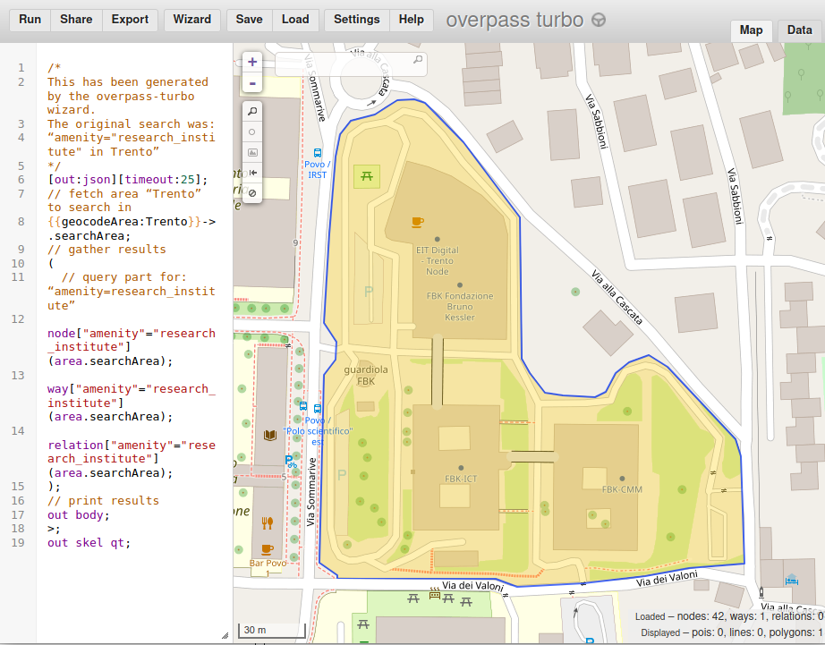
import geopandas as gpd
fbk = gpd.read_file("https://raw.githubusercontent.com/napo/geospatial_course_unitn/master/data/openstreetmap/boundary_fbk_povo.geojson")
fbk.plot()
plt.show()
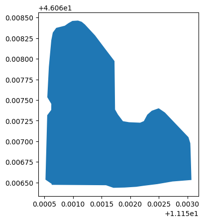
fbk
| id | @id | addr:city | addr:housenumber | addr:postcode | addr:street | amenity | name | website | geometry | |
|---|---|---|---|---|---|---|---|---|---|---|
| 0 | way/813142998 | way/813142998 | Povo | 18 | 38123 | Via Sommarive | research_institute | Fondazione Bruno Kessler | https://www.fbk.eu/ | POLYGON ((11.15071 46.06837, 11.15065 46.06832... |
def getFeatures(gdf):
    """Function to parse features from GeoDataFrame in such a manner that rasterio wants them"""
    import json
    return [json.loads(gdf.to_json())['features'][0]['geometry']]
coords = getFeatures(fbk.to_crs(epsg=25832))
coords
[{'type': 'Polygon',
  'coordinates': [[[666327.6121890642, 5103893.127195438],
    [666323.144271185, 5103886.635365136],
    [666321.3931118533, 5103876.125343578],
    [666319.0792195683, 5103840.3496225],
    [666318.0826114198, 5103799.36152162],
    [666323.7228536663, 5103790.552413938],
    [666323.8345305179, 5103782.416574045],
    [666318.6225224709, 5103775.104085964],
    [666318.6091393529, 5103688.31146606],
    [666327.0838932644, 5103682.87013375],
    [666327.1737856156, 5103681.549444295],
    [666400.6669444224, 5103682.9926035525],
    [666410.7295525032, 5103679.7958390545],
    [666425.792733877, 5103680.570343598],
    [666441.5815165223, 5103681.987167167],
    [666451.6897212835, 5103683.683917669],
    [666470.004685441, 5103686.414475457],
    [666490.3886287892, 5103690.4797439],
    [666515.9557992362, 5103693.195510002],
    [666513.463898501, 5103736.924514817],
    [666513.0686339957, 5103742.662169834],
    [666510.3745651151, 5103750.69474607],
    [666494.0244603783, 5103766.874524173],
    [666477.6265348198, 5103783.1086405795],
    [666469.0809623704, 5103788.592324361],
    [666459.7905892088, 5103784.994140762],
    [666453.9315266104, 5103779.576428253],
    [666449.464622381, 5103770.760729854],
    [666444.5186840823, 5103768.492087739],
    [666429.6068333589, 5103768.711182879],
    [666421.1696051474, 5103769.906057021],
    [666414.1192751501, 5103778.765877374],
    [666410.1262133094, 5103785.329032989],
    [666407.6113483374, 5103850.527577802],
    [666394.591997934, 5103866.61982207],
    [666380.3336598724, 5103884.457557872],
    [666366.2872835831, 5103898.754201977],
    [666361.8118494605, 5103902.268938324],
    [666356.7947404401, 5103903.778783713],
    [666349.1976195036, 5103903.1062985],
    [666344.027126861, 5103899.986640299],
    [666339.1182247801, 5103896.351484859],
    [666327.6121890642, 5103893.127195438]]]}]
from rasterio.mask import mask
out_img, out_transform = mask(raster, coords, crop=True)
out_meta = raster.meta
show(out_img)
<AxesSubplot:>
out_meta.update({"driver": "GTiff",
                 "height": out_img.shape[1],
                 "width": out_img.shape[2],
                 "transform": out_transform})

with rio.open("fbk_orthophoto.tif", "w", **out_meta) as dest:
    dest.write(out_img)
raster to vector
resampled_area = rio.open('resampled_area.tif')
from rasterio.features import shapes
mask = None
image = resampled_area.read(1) # first band
results = (
  {'properties': {'raster_val': v}, 'geometry': s}
  for i, (s, v)
    in enumerate(
      shapes(image, mask=mask, transform=resampled_area.transform)))
geoms = list(results)
%time
CPU times: user 7 µs, sys: 1 µs, total: 8 µs
Wall time: 15.5 µs
geoms
[{'properties': {'raster_val': 77.0},
'geometry': {'type': 'Polygon',
'coordinates': [[(666100.6735466761, 5104013.23583161),
(666100.6735466761, 5104008.23583161),
(666107.6735466761, 5104008.23583161),
(666107.6735466761, 5104013.23583161),
(666100.6735466761, 5104013.23583161)]]}},
{'properties': {'raster_val': 76.0},
'geometry': {'type': 'Polygon',
'coordinates': [[(666107.6735466761, 5104013.23583161),
(666107.6735466761, 5104008.23583161),
(666113.6735466761, 5104008.23583161),
(666113.6735466761, 5104013.23583161),
(666107.6735466761, 5104013.23583161)]]}},
{'properties': {'raster_val': 76.0},
'geometry': {'type': 'Polygon',
'coordinates': [[(666137.6735466761, 5104013.23583161),
(666137.6735466761, 5104008.23583161),
(666143.6735466761, 5104008.23583161),
(666143.6735466761, 5104013.23583161),
(666137.6735466761, 5104013.23583161)]]}},
{'properties': {'raster_val': 78.0},
'geometry': {'type': 'Polygon',
'coordinates': [[(666143.6735466761, 5104013.23583161),
(666143.6735466761, 5104008.23583161),
(666149.6735466761, 5104008.23583161),
(666149.6735466761, 5104013.23583161),
(666143.6735466761, 5104013.23583161)]]}},
{'properties': {'raster_val': 81.0},
'geometry': {'type': 'Polygon',
'coordinates': [[(666149.6735466761, 5104013.23583161),
(666149.6735466761, 5104008.23583161),
(666155.6735466761, 5104008.23583161),
(666155.6735466761, 5104013.23583161),
(666149.6735466761, 5104013.23583161)]]}},
{'properties': {'raster_val': 84.0},
'geometry': {'type': 'Polygon',
'coordinates': [[(666155.6735466761, 5104013.23583161),
(666155.6735466761, 5104008.23583161),
(666161.6735466761, 5104008.23583161),
(666161.6735466761, 5104013.23583161),
(666155.6735466761, 5104013.23583161)]]}},
{'properties': {'raster_val': 86.0},
'geometry': {'type': 'Polygon',
'coordinates': [[(666161.6735466761, 5104013.23583161),
(666161.6735466761, 5104008.23583161),
(666168.6735466761, 5104008.23583161),
(666168.6735466761, 5104013.23583161),
(666161.6735466761, 5104013.23583161)]]}},
{'properties': {'raster_val': 92.0},
'geometry': {'type': 'Polygon',
'coordinates': [[(666204.6735466761, 5104013.23583161),
(666204.6735466761, 5104008.23583161),
(666210.6735466761, 5104008.23583161),
(666210.6735466761, 5104013.23583161),
(666204.6735466761, 5104013.23583161)]]}},
{'properties': {'raster_val': 95.0},
'geometry': {'type': 'Polygon',
'coordinates': [[(666210.6735466761, 5104013.23583161),
(666210.6735466761, 5104008.23583161),
(666216.6735466761, 5104008.23583161),
(666216.6735466761, 5104013.23583161),
(666210.6735466761, 5104013.23583161)]]}},
{'properties': {'raster_val': 99.0},
'geometry': {'type': 'Polygon',
'coordinates': [[(666216.6735466761, 5104013.23583161),
(666216.6735466761, 5104008.23583161),
(666222.6735466761, 5104008.23583161),
(666222.6735466761, 5104013.23583161),
(666216.6735466761, 5104013.23583161)]]}},
{'properties': {'raster_val': 101.0},
'geometry': {'type': 'Polygon',
'coordinates': [[(666222.6735466761, 5104013.23583161),
(666222.6735466761, 5104008.23583161),
(666229.6735466761, 5104008.23583161),
(666229.6735466761, 5104013.23583161),
(666222.6735466761, 5104013.23583161)]]}},
{'properties': {'raster_val': 103.0},
'geometry': {'type': 'Polygon',
'coordinates': [[(666229.6735466761, 5104013.23583161),
(666229.6735466761, 5104008.23583161),
(666235.6735466761, 5104008.23583161),
(666235.6735466761, 5104013.23583161),
(666229.6735466761, 5104013.23583161)]]}},
{'properties': {'raster_val': 109.0},
'geometry': {'type': 'Polygon',
'coordinates': [[(666241.6735466761, 5104013.23583161),
(666241.6735466761, 5104008.23583161),
(666247.6735466761, 5104008.23583161),
(666247.6735466761, 5104013.23583161),
(666241.6735466761, 5104013.23583161)]]}},
{'properties': {'raster_val': 111.0},
'geometry': {'type': 'Polygon',
'coordinates': [[(666247.6735466761, 5104013.23583161),
(666247.6735466761, 5104008.23583161),
(666253.6735466761, 5104008.23583161),
(666253.6735466761, 5104013.23583161),
(666247.6735466761, 5104013.23583161)]]}},
{'properties': {'raster_val': 121.0},
'geometry': {'type': 'Polygon',
'coordinates': [[(666296.6735466761, 5104013.23583161),
(666296.6735466761, 5104008.23583161),
(666302.6735466761, 5104008.23583161),
(666302.6735466761, 5104013.23583161),
(666296.6735466761, 5104013.23583161)]]}},
{'properties': {'raster_val': 133.0},
'geometry': {'type': 'Polygon',
'coordinates': [[(666338.6735466761, 5104013.23583161),
(666338.6735466761, 5104008.23583161),
(666344.6735466761, 5104008.23583161),
(666344.6735466761, 5104013.23583161),
(666338.6735466761, 5104013.23583161)]]}},
{'properties': {'raster_val': 149.0},
'geometry': {'type': 'Polygon',
'coordinates': [[(666479.6735466761, 5104013.23583161),
(666479.6735466761, 5104008.23583161),
(666485.6735466761, 5104008.23583161),
(666485.6735466761, 5104013.23583161),
(666479.6735466761, 5104013.23583161)]]}},
{'properties': {'raster_val': 150.0},
'geometry': {'type': 'Polygon',
'coordinates': [[(666485.6735466761, 5104013.23583161),
(666485.6735466761, 5104008.23583161),
(666491.6735466761, 5104008.23583161),
(666491.6735466761, 5104013.23583161),
(666485.6735466761, 5104013.23583161)]]}},
{'properties': {'raster_val': 171.0},
'geometry': {'type': 'Polygon',
'coordinates': [[(666533.6735466761, 5104013.23583161),
(666533.6735466761, 5104008.23583161),
(666540.6735466761, 5104008.23583161),
(666540.6735466761, 5104013.23583161),
(666533.6735466761, 5104013.23583161)]]}},
{'properties': {'raster_val': 176.0},
'geometry': {'type': 'Polygon',
'coordinates': [[(666540.6735466761, 5104013.23583161),
(666540.6735466761, 5104008.23583161),
(666546.6735466761, 5104008.23583161),
(666546.6735466761, 5104013.23583161),
(666540.6735466761, 5104013.23583161)]]}},
{'properties': {'raster_val': 186.0},
'geometry': {'type': 'Polygon',
'coordinates': [[(666558.6735466761, 5104013.23583161),
(666558.6735466761, 5104008.23583161),
(666564.6735466761, 5104008.23583161),
(666564.6735466761, 5104013.23583161),
(666558.6735466761, 5104013.23583161)]]}},
{'properties': {'raster_val': 188.0},
'geometry': {'type': 'Polygon',
'coordinates': [[(666564.6735466761, 5104013.23583161),
(666564.6735466761, 5104008.23583161),
(666570.6735466761, 5104008.23583161),
(666570.6735466761, 5104013.23583161),
(666564.6735466761, 5104013.23583161)]]}},
{'properties': {'raster_val': 196.0},
'geometry': {'type': 'Polygon',
'coordinates': [[(666576.6735466761, 5104013.23583161),
(666576.6735466761, 5104008.23583161),
(666582.6735466761, 5104008.23583161),
(666582.6735466761, 5104013.23583161),
(666576.6735466761, 5104013.23583161)]]}},
{'properties': {'raster_val': 201.0},
'geometry': {'type': 'Polygon',
'coordinates': [[(666582.6735466761, 5104013.23583161),
(666582.6735466761, 5104008.23583161),
(666588.6735466761, 5104008.23583161),
(666588.6735466761, 5104013.23583161),
(666582.6735466761, 5104013.23583161)]]}},
{'properties': {'raster_val': 207.0},
'geometry': {'type': 'Polygon',
'coordinates': [[(666588.6735466761, 5104013.23583161),
(666588.6735466761, 5104008.23583161),
(666594.6735466761, 5104008.23583161),
(666594.6735466761, 5104013.23583161),
(666588.6735466761, 5104013.23583161)]]}},
{'properties': {'raster_val': 211.0},
'geometry': {'type': 'Polygon',
'coordinates': [[(666594.6735466761, 5104013.23583161),
(666594.6735466761, 5104008.23583161),
(666600.6735466761, 5104008.23583161),
(666600.6735466761, 5104013.23583161),
(666594.6735466761, 5104013.23583161)]]}},
{'properties': {'raster_val': 75.0},
'geometry': {'type': 'Polygon',
'coordinates': [[(666113.6735466761, 5104013.23583161),
(666113.6735466761, 5104008.23583161),
(666119.6735466761, 5104008.23583161),
(666119.6735466761, 5104004.23583161),
(666125.6735466761, 5104004.23583161),
(666125.6735466761, 5104008.23583161),
(666137.6735466761, 5104008.23583161),
(666137.6735466761, 5104013.23583161),
(666113.6735466761, 5104013.23583161)]]}},
{'properties': {'raster_val': 91.0},
'geometry': {'type': 'Polygon',
'coordinates': [[(666198.6735466761, 5104013.23583161),
(666198.6735466761, 5104004.23583161),
(666204.6735466761, 5104004.23583161),
(666204.6735466761, 5104013.23583161),
(666198.6735466761, 5104013.23583161)]]}},
{'properties': {'raster_val': 107.0},
'geometry': {'type': 'Polygon',
'coordinates': [[(666235.6735466761, 5104013.23583161),
(666235.6735466761, 5104004.23583161),
(666241.6735466761, 5104004.23583161),
(666241.6735466761, 5104013.23583161),
(666235.6735466761, 5104013.23583161)]]}},
{'properties': {'raster_val': 116.0},
'geometry': {'type': 'Polygon',
'coordinates': [[(666277.6735466761, 5104013.23583161),
(666277.6735466761, 5104004.23583161),
(666283.6735466761, 5104004.23583161),
(666283.6735466761, 5104013.23583161),
(666277.6735466761, 5104013.23583161)]]}},
{'properties': {'raster_val': 122.0},
'geometry': {'type': 'Polygon',
'coordinates': [[(666302.6735466761, 5104013.23583161),
(666302.6735466761, 5104004.23583161),
(666308.6735466761, 5104004.23583161),
(666308.6735466761, 5104013.23583161),
(666302.6735466761, 5104013.23583161)]]}},
{'properties': {'raster_val': 124.0},
'geometry': {'type': 'Polygon',
'coordinates': [[(666308.6735466761, 5104013.23583161),
(666308.6735466761, 5104004.23583161),
(666314.6735466761, 5104004.23583161),
(666314.6735466761, 5104013.23583161),
(666308.6735466761, 5104013.23583161)]]}},
{'properties': {'raster_val': 125.0},
'geometry': {'type': 'Polygon',
'coordinates': [[(666314.6735466761, 5104013.23583161),
(666314.6735466761, 5104000.23583161),
(666320.6735466761, 5104000.23583161),
(666320.6735466761, 5104013.23583161),
(666314.6735466761, 5104013.23583161)]]}},
{'properties': {'raster_val': 126.0},
'geometry': {'type': 'Polygon',
'coordinates': [[(666320.6735466761, 5104013.23583161),
(666320.6735466761, 5104000.23583161),
(666326.6735466761, 5104000.23583161),
(666326.6735466761, 5104013.23583161),
(666320.6735466761, 5104013.23583161)]]}},
{'properties': {'raster_val': 144.0},
'geometry': {'type': 'Polygon',
'coordinates': [[(666448.6735466761, 5104013.23583161),
(666448.6735466761, 5104004.23583161),
(666454.6735466761, 5104004.23583161),
(666454.6735466761, 5104013.23583161),
(666448.6735466761, 5104013.23583161)]]}},
{'properties': {'raster_val': 146.0},
'geometry': {'type': 'Polygon',
'coordinates': [[(666466.6735466761, 5104013.23583161),
(666466.6735466761, 5104000.23583161),
(666472.6735466761, 5104000.23583161),
(666472.6735466761, 5104013.23583161),
(666466.6735466761, 5104013.23583161)]]}},
{'properties': {'raster_val': 148.0},
'geometry': {'type': 'Polygon',
'coordinates': [[(666472.6735466761, 5104013.23583161),
(666472.6735466761, 5104004.23583161),
(666479.6735466761, 5104004.23583161),
(666479.6735466761, 5104000.23583161),
(666485.6735466761, 5104000.23583161),
(666485.6735466761, 5104008.23583161),
(666479.6735466761, 5104008.23583161),
(666479.6735466761, 5104013.23583161),
(666472.6735466761, 5104013.23583161)]]}},
{'properties': {'raster_val': 151.0},
'geometry': {'type': 'Polygon',
'coordinates': [[(666491.6735466761, 5104013.23583161),
(666491.6735466761, 5104004.23583161),
(666497.6735466761, 5104004.23583161),
(666497.6735466761, 5104013.23583161),
(666491.6735466761, 5104013.23583161)]]}},
{'properties': {'raster_val': 152.0},
'geometry': {'type': 'Polygon',
'coordinates': [[(666497.6735466761, 5104013.23583161),
(666497.6735466761, 5104004.23583161),
(666503.6735466761, 5104004.23583161),
(666503.6735466761, 5104013.23583161),
(666497.6735466761, 5104013.23583161)]]}},
{'properties': {'raster_val': 153.0},
'geometry': {'type': 'Polygon',
'coordinates': [[(666503.6735466761, 5104013.23583161),
(666503.6735466761, 5104004.23583161),
(666509.6735466761, 5104004.23583161),
(666509.6735466761, 5104013.23583161),
(666503.6735466761, 5104013.23583161)]]}},
{'properties': {'raster_val': 154.0},
'geometry': {'type': 'Polygon',
'coordinates': [[(666509.6735466761, 5104013.23583161),
(666509.6735466761, 5104004.23583161),
(666515.6735466761, 5104004.23583161),
(666515.6735466761, 5104013.23583161),
(666509.6735466761, 5104013.23583161)]]}},
{'properties': {'raster_val': 163.0},
'geometry': {'type': 'Polygon',
'coordinates': [[(666521.6735466761, 5104013.23583161),
(666521.6735466761, 5104004.23583161),
(666527.6735466761, 5104004.23583161),
(666527.6735466761, 5104013.23583161),
(666521.6735466761, 5104013.23583161)]]}},
{'properties': {'raster_val': 168.0},
'geometry': {'type': 'Polygon',
'coordinates': [[(666527.6735466761, 5104013.23583161),
(666527.6735466761, 5104004.23583161),
(666533.6735466761, 5104004.23583161),
(666533.6735466761, 5104013.23583161),
(666527.6735466761, 5104013.23583161)]]}},
{'properties': {'raster_val': 180.0},
'geometry': {'type': 'Polygon',
'coordinates': [[(666546.6735466761, 5104013.23583161),
(666546.6735466761, 5104004.23583161),
(666552.6735466761, 5104004.23583161),
(666552.6735466761, 5104013.23583161),
(666546.6735466761, 5104013.23583161)]]}},
{'properties': {'raster_val': 183.0},
'geometry': {'type': 'Polygon',
'coordinates': [[(666552.6735466761, 5104013.23583161),
(666552.6735466761, 5104004.23583161),
(666558.6735466761, 5104004.23583161),
(666558.6735466761, 5104013.23583161),
(666552.6735466761, 5104013.23583161)]]}},
{'properties': {'raster_val': 192.0},
'geometry': {'type': 'Polygon',
'coordinates': [[(666570.6735466761, 5104013.23583161),
(666570.6735466761, 5104004.23583161),
(666576.6735466761, 5104004.23583161),
(666576.6735466761, 5104013.23583161),
(666570.6735466761, 5104013.23583161)]]}},
{'properties': {'raster_val': 74.0},
'geometry': {'type': 'Polygon',
'coordinates': [[(666100.6735466761, 5104008.23583161),
(666100.6735466761, 5104004.23583161),
(666107.6735466761, 5104004.23583161),
(666107.6735466761, 5104008.23583161),
(666100.6735466761, 5104008.23583161)]]}},
{'properties': {'raster_val': 73.0},
'geometry': {'type': 'Polygon',
'coordinates': [[(666107.6735466761, 5104008.23583161),
(666107.6735466761, 5104004.23583161),
(666113.6735466761, 5104004.23583161),
(666113.6735466761, 5104008.23583161),
(666107.6735466761, 5104008.23583161)]]}},
{'properties': {'raster_val': 74.0},
'geometry': {'type': 'Polygon',
'coordinates': [[(666113.6735466761, 5104008.23583161),
(666113.6735466761, 5104000.23583161),
(666119.6735466761, 5104000.23583161),
(666119.6735466761, 5104008.23583161),
(666113.6735466761, 5104008.23583161)]]}},
{'properties': {'raster_val': 76.0},
'geometry': {'type': 'Polygon',
'coordinates': [[(666125.6735466761, 5104008.23583161),
(666125.6735466761, 5104004.23583161),
(666131.6735466761, 5104004.23583161),
(666131.6735466761, 5104008.23583161),
(666125.6735466761, 5104008.23583161)]]}},
{'properties': {'raster_val': 77.0},
'geometry': {'type': 'Polygon',
'coordinates': [[(666131.6735466761, 5104008.23583161),
(666131.6735466761, 5104004.23583161),
(666137.6735466761, 5104004.23583161),
(666137.6735466761, 5104008.23583161),
(666131.6735466761, 5104008.23583161)]]}},
{'properties': {'raster_val': 78.0},
'geometry': {'type': 'Polygon',
'coordinates': [[(666137.6735466761, 5104008.23583161),
(666137.6735466761, 5104004.23583161),
(666143.6735466761, 5104004.23583161),
(666143.6735466761, 5104008.23583161),
(666137.6735466761, 5104008.23583161)]]}},
{'properties': {'raster_val': 81.0},
'geometry': {'type': 'Polygon',
'coordinates': [[(666143.6735466761, 5104008.23583161),
(666143.6735466761, 5104004.23583161),
(666149.6735466761, 5104004.23583161),
(666149.6735466761, 5104008.23583161),
(666143.6735466761, 5104008.23583161)]]}},
{'properties': {'raster_val': 83.0},
'geometry': {'type': 'Polygon',
'coordinates': [[(666149.6735466761, 5104008.23583161),
(666149.6735466761, 5104004.23583161),
(666155.6735466761, 5104004.23583161),
(666155.6735466761, 5104008.23583161),
(666149.6735466761, 5104008.23583161)]]}},
{'properties': {'raster_val': 86.0},
'geometry': {'type': 'Polygon',
'coordinates': [[(666155.6735466761, 5104008.23583161),
(666155.6735466761, 5104000.23583161),
(666161.6735466761, 5104000.23583161),
(666161.6735466761, 5104008.23583161),
(666155.6735466761, 5104008.23583161)]]}},
{'properties': {'raster_val': 93.0},
'geometry': {'type': 'Polygon',
'coordinates': [[(666204.6735466761, 5104008.23583161),
(666204.6735466761, 5104004.23583161),
(666210.6735466761, 5104004.23583161),
(666210.6735466761, 5104008.23583161),
(666204.6735466761, 5104008.23583161)]]}},
{'properties': {'raster_val': 96.0},
'geometry': {'type': 'Polygon',
'coordinates': [[(666210.6735466761, 5104008.23583161),
(666210.6735466761, 5104004.23583161),
(666216.6735466761, 5104004.23583161),
(666216.6735466761, 5104008.23583161),
(666210.6735466761, 5104008.23583161)]]}},
{'properties': {'raster_val': 100.0},
'geometry': {'type': 'Polygon',
'coordinates': [[(666216.6735466761, 5104008.23583161),
(666216.6735466761, 5104004.23583161),
(666222.6735466761, 5104004.23583161),
(666222.6735466761, 5104008.23583161),
(666216.6735466761, 5104008.23583161)]]}},
{'properties': {'raster_val': 102.0},
'geometry': {'type': 'Polygon',
'coordinates': [[(666222.6735466761, 5104008.23583161),
(666222.6735466761, 5104004.23583161),
(666229.6735466761, 5104004.23583161),
(666229.6735466761, 5104008.23583161),
(666222.6735466761, 5104008.23583161)]]}},
{'properties': {'raster_val': 105.0},
'geometry': {'type': 'Polygon',
'coordinates': [[(666229.6735466761, 5104008.23583161),
(666229.6735466761, 5104004.23583161),
(666235.6735466761, 5104004.23583161),
(666235.6735466761, 5104008.23583161),
(666229.6735466761, 5104008.23583161)]]}},
{'properties': {'raster_val': 110.0},
'geometry': {'type': 'Polygon',
'coordinates': [[(666241.6735466761, 5104008.23583161),
(666241.6735466761, 5104000.23583161),
(666247.6735466761, 5104000.23583161),
(666247.6735466761, 5104008.23583161),
(666241.6735466761, 5104008.23583161)]]}},
{'properties': {'raster_val': 120.0},
'geometry': {'type': 'Polygon',
'coordinates': [[(666296.6735466761, 5104008.23583161),
(666296.6735466761, 5104000.23583161),
(666302.6735466761, 5104000.23583161),
(666302.6735466761, 5104008.23583161),
(666296.6735466761, 5104008.23583161)]]}},
{'properties': {'raster_val': 149.0},
'geometry': {'type': 'Polygon',
'coordinates': [[(666485.6735466761, 5104008.23583161),
(666485.6735466761, 5104000.23583161),
(666491.6735466761, 5104000.23583161),
(666491.6735466761, 5104008.23583161),
(666485.6735466761, 5104008.23583161)]]}},
{'properties': {'raster_val': 173.0},
'geometry': {'type': 'Polygon',
'coordinates': [[(666533.6735466761, 5104008.23583161),
(666533.6735466761, 5104004.23583161),
(666540.6735466761, 5104004.23583161),
(666540.6735466761, 5104008.23583161),
(666533.6735466761, 5104008.23583161)]]}},
{'properties': {'raster_val': 177.0},
'geometry': {'type': 'Polygon',
'coordinates': [[(666540.6735466761, 5104008.23583161),
(666540.6735466761, 5104004.23583161),
(666546.6735466761, 5104004.23583161),
(666546.6735466761, 5104008.23583161),
(666540.6735466761, 5104008.23583161)]]}},
{'properties': {'raster_val': 189.0},
'geometry': {'type': 'Polygon',
'coordinates': [[(666564.6735466761, 5104008.23583161),
(666564.6735466761, 5104000.23583161),
(666570.6735466761, 5104000.23583161),
(666570.6735466761, 5104008.23583161),
(666564.6735466761, 5104008.23583161)]]}},
{'properties': {'raster_val': 197.0},
'geometry': {'type': 'Polygon',
'coordinates': [[(666576.6735466761, 5104008.23583161),
(666576.6735466761, 5104004.23583161),
(666582.6735466761, 5104004.23583161),
(666582.6735466761, 5104008.23583161),
(666576.6735466761, 5104008.23583161)]]}},
{'properties': {'raster_val': 204.0},
'geometry': {'type': 'Polygon',
'coordinates': [[(666582.6735466761, 5104008.23583161),
(666582.6735466761, 5104004.23583161),
(666588.6735466761, 5104004.23583161),
(666588.6735466761, 5104008.23583161),
(666582.6735466761, 5104008.23583161)]]}},
{'properties': {'raster_val': 209.0},
'geometry': {'type': 'Polygon',
'coordinates': [[(666588.6735466761, 5104008.23583161),
(666588.6735466761, 5104004.23583161),
(666594.6735466761, 5104004.23583161),
(666594.6735466761, 5104008.23583161),
(666588.6735466761, 5104008.23583161)]]}},
{'properties': {'raster_val': 212.0},
'geometry': {'type': 'Polygon',
'coordinates': [[(666594.6735466761, 5104008.23583161),
(666594.6735466761, 5104004.23583161),
(666600.6735466761, 5104004.23583161),
(666600.6735466761, 5104008.23583161),
(666594.6735466761, 5104008.23583161)]]}},
{'properties': {'raster_val': 72.0},
'geometry': {'type': 'Polygon',
'coordinates': [[(666100.6735466761, 5104004.23583161),
(666100.6735466761, 5104000.23583161),
(666107.6735466761, 5104000.23583161),
(666107.6735466761, 5104004.23583161),
(666100.6735466761, 5104004.23583161)]]}},
{'properties': {'raster_val': 71.0},
'geometry': {'type': 'Polygon',
'coordinates': [[(666107.6735466761, 5104004.23583161),
(666107.6735466761, 5104000.23583161),
(666113.6735466761, 5104000.23583161),
(666113.6735466761, 5104004.23583161),
(666107.6735466761, 5104004.23583161)]]}},
{'properties': {'raster_val': 77.0},
'geometry': {'type': 'Polygon',
'coordinates': [[(666119.6735466761, 5104004.23583161),
(666119.6735466761, 5104000.23583161),
(666125.6735466761, 5104000.23583161),
(666125.6735466761, 5104004.23583161),
(666119.6735466761, 5104004.23583161)]]}},
{'properties': {'raster_val': 79.0},
'geometry': {'type': 'Polygon',
'coordinates': [[(666125.6735466761, 5104004.23583161),
(666125.6735466761, 5104000.23583161),
(666131.6735466761, 5104000.23583161),
(666131.6735466761, 5104004.23583161),
(666125.6735466761, 5104004.23583161)]]}},
{'properties': {'raster_val': 80.0},
'geometry': {'type': 'Polygon',
'coordinates': [[(666131.6735466761, 5104004.23583161),
(666131.6735466761, 5104000.23583161),
(666137.6735466761, 5104000.23583161),
(666137.6735466761, 5104004.23583161),
(666131.6735466761, 5104004.23583161)]]}},
{'properties': {'raster_val': 81.0},
'geometry': {'type': 'Polygon',
'coordinates': [[(666137.6735466761, 5104004.23583161),
(666137.6735466761, 5104000.23583161),
(666143.6735466761, 5104000.23583161),
(666143.6735466761, 5104004.23583161),
(666137.6735466761, 5104004.23583161)]]}},
{'properties': {'raster_val': 83.0},
'geometry': {'type': 'Polygon',
'coordinates': [[(666143.6735466761, 5104004.23583161),
(666143.6735466761, 5104000.23583161),
(666149.6735466761, 5104000.23583161),
(666149.6735466761, 5104004.23583161),
(666143.6735466761, 5104004.23583161)]]}},
{'properties': {'raster_val': 85.0},
'geometry': {'type': 'Polygon',
'coordinates': [[(666149.6735466761, 5104004.23583161),
(666149.6735466761, 5104000.23583161),
(666155.6735466761, 5104000.23583161),
(666155.6735466761, 5104004.23583161),
(666149.6735466761, 5104004.23583161)]]}},
{'properties': {'raster_val': 92.0},
'geometry': {'type': 'Polygon',
'coordinates': [[(666198.6735466761, 5104004.23583161),
(666198.6735466761, 5104000.23583161),
(666204.6735466761, 5104000.23583161),
(666204.6735466761, 5104004.23583161),
(666198.6735466761, 5104004.23583161)]]}},
{'properties': {'raster_val': 95.0},
'geometry': {'type': 'Polygon',
'coordinates': [[(666204.6735466761, 5104004.23583161),
(666204.6735466761, 5104000.23583161),
(666210.6735466761, 5104000.23583161),
(666210.6735466761, 5104004.23583161),
(666204.6735466761, 5104004.23583161)]]}},
{'properties': {'raster_val': 98.0},
'geometry': {'type': 'Polygon',
'coordinates': [[(666210.6735466761, 5104004.23583161),
(666210.6735466761, 5104000.23583161),
(666216.6735466761, 5104000.23583161),
(666216.6735466761, 5104004.23583161),
(666210.6735466761, 5104004.23583161)]]}},
{'properties': {'raster_val': 101.0},
'geometry': {'type': 'Polygon',
'coordinates': [[(666216.6735466761, 5104004.23583161),
(666216.6735466761, 5104000.23583161),
(666222.6735466761, 5104000.23583161),
(666222.6735466761, 5104004.23583161),
(666216.6735466761, 5104004.23583161)]]}},
{'properties': {'raster_val': 103.0},
'geometry': {'type': 'Polygon',
'coordinates': [[(666222.6735466761, 5104004.23583161),
(666222.6735466761, 5104000.23583161),
(666229.6735466761, 5104000.23583161),
(666229.6735466761, 5104004.23583161),
(666222.6735466761, 5104004.23583161)]]}},
{'properties': {'raster_val': 106.0},
'geometry': {'type': 'Polygon',
'coordinates': [[(666229.6735466761, 5104004.23583161),
(666229.6735466761, 5104000.23583161),
(666235.6735466761, 5104000.23583161),
(666235.6735466761, 5104004.23583161),
(666229.6735466761, 5104004.23583161)]]}},
{'properties': {'raster_val': 108.0},
'geometry': {'type': 'Polygon',
'coordinates': [[(666235.6735466761, 5104004.23583161),
(666235.6735466761, 5104000.23583161),
(666241.6735466761, 5104000.23583161),
(666241.6735466761, 5104004.23583161),
(666235.6735466761, 5104004.23583161)]]}},
{'properties': {'raster_val': 147.0},
'geometry': {'type': 'Polygon',
'coordinates': [[(666472.6735466761, 5104004.23583161),
(666472.6735466761, 5104000.23583161),
(666479.6735466761, 5104000.23583161),
(666479.6735466761, 5104004.23583161),
(666472.6735466761, 5104004.23583161)]]}},
{'properties': {'raster_val': 150.0},
'geometry': {'type': 'Polygon',
'coordinates': [[(666491.6735466761, 5104004.23583161),
(666491.6735466761, 5104000.23583161),
(666497.6735466761, 5104000.23583161),
(666497.6735466761, 5104004.23583161),
(666491.6735466761, 5104004.23583161)]]}},
{'properties': {'raster_val': 164.0},
'geometry': {'type': 'Polygon',
'coordinates': [[(666521.6735466761, 5104004.23583161),
(666521.6735466761, 5104000.23583161),
(666527.6735466761, 5104000.23583161),
(666527.6735466761, 5104004.23583161),
(666521.6735466761, 5104004.23583161)]]}},
{'properties': {'raster_val': 194.0},
'geometry': {'type': 'Polygon',
'coordinates': [[(666570.6735466761, 5104004.23583161),
(666570.6735466761, 5104000.23583161),
(666576.6735466761, 5104000.23583161),
(666576.6735466761, 5104004.23583161),
(666570.6735466761, 5104004.23583161)]]}},
{'properties': {'raster_val': 202.0},
'geometry': {'type': 'Polygon',
'coordinates': [[(666576.6735466761, 5104004.23583161),
(666576.6735466761, 5104000.23583161),
(666582.6735466761, 5104000.23583161),
(666582.6735466761, 5104004.23583161),
(666576.6735466761, 5104004.23583161)]]}},
{'properties': {'raster_val': 117.0},
'geometry': {'type': 'Polygon',
'coordinates': [[(666283.6735466761, 5104013.23583161),
(666283.6735466761, 5103992.23583161),
(666290.6735466761, 5103992.23583161),
(666290.6735466761, 5104013.23583161),
(666283.6735466761, 5104013.23583161)]]}},
{'properties': {'raster_val': 128.0},
'geometry': {'type': 'Polygon',
'coordinates': [[(666326.6735466761, 5104013.23583161),
(666326.6735466761, 5103996.23583161),
(666332.6735466761, 5103996.23583161),
(666332.6735466761, 5104013.23583161),
(666326.6735466761, 5104013.23583161)]]}},
{'properties': {'raster_val': 131.0},
'geometry': {'type': 'Polygon',
'coordinates': [[(666332.6735466761, 5104013.23583161),
(666332.6735466761, 5103996.23583161),
(666338.6735466761, 5103996.23583161),
(666338.6735466761, 5104013.23583161),
(666332.6735466761, 5104013.23583161)]]}},
{'properties': {'raster_val': 139.0},
'geometry': {'type': 'Polygon',
'coordinates': [[(666411.6735466761, 5104013.23583161),
(666411.6735466761, 5104000.23583161),
(666418.6735466761, 5104000.23583161),
(666418.6735466761, 5103992.23583161),
(666424.6735466761, 5103992.23583161),
(666424.6735466761, 5104013.23583161),
(666411.6735466761, 5104013.23583161)]]}},
{'properties': {'raster_val': 134.0},
'geometry': {'type': 'Polygon',
'coordinates': [[(666338.6735466761, 5104008.23583161),
(666338.6735466761, 5103996.23583161),
(666344.6735466761, 5103996.23583161),
(666344.6735466761, 5104008.23583161),
(666338.6735466761, 5104008.23583161)]]}},
{'properties': {'raster_val': 90.0},
'geometry': {'type': 'Polygon',
'coordinates': [[(666192.6735466761, 5104013.23583161),
(666198.6735466761, 5104013.23583161),
(666198.6735466761, 5104000.23583161),
(666192.6735466761, 5104000.23583161),
(666192.6735466761, 5103992.23583161),
(666186.6735466761, 5103992.23583161),
(666186.6735466761, 5104004.23583161),
(666192.6735466761, 5104004.23583161),
(666192.6735466761, 5104013.23583161)]]}},
{'properties': {'raster_val': 143.0},
'geometry': {'type': 'Polygon',
'coordinates': [[(666448.6735466761, 5104004.23583161),
(666448.6735466761, 5103992.23583161),
(666454.6735466761, 5103992.23583161),
(666454.6735466761, 5104004.23583161),
(666448.6735466761, 5104004.23583161)]]}},
{'properties': {'raster_val': 151.0},
'geometry': {'type': 'Polygon',
'coordinates': [[(666497.6735466761, 5104004.23583161),
(666497.6735466761, 5103996.23583161),
(666503.6735466761, 5103996.23583161),
(666503.6735466761, 5104004.23583161),
(666497.6735466761, 5104004.23583161)]]}},
{'properties': {'raster_val': 152.0},
'geometry': {'type': 'Polygon',
'coordinates': [[(666503.6735466761, 5104004.23583161),
(666503.6735466761, 5103992.23583161),
(666509.6735466761, 5103992.23583161),
(666509.6735466761, 5104004.23583161),
(666503.6735466761, 5104004.23583161)]]}},
{'properties': {'raster_val': 169.0},
'geometry': {'type': 'Polygon',
'coordinates': [[(666527.6735466761, 5104004.23583161),
(666527.6735466761, 5103996.23583161),
(666533.6735466761, 5103996.23583161),
(666533.6735466761, 5104004.23583161),
(666527.6735466761, 5104004.23583161)]]}},
{'properties': {'raster_val': 174.0},
'geometry': {'type': 'Polygon',
'coordinates': [[(666533.6735466761, 5104004.23583161),
(666533.6735466761, 5103992.23583161),
(666540.6735466761, 5103992.23583161),
(666540.6735466761, 5104004.23583161),
(666533.6735466761, 5104004.23583161)]]}},
{'properties': {'raster_val': 178.0},
'geometry': {'type': 'Polygon',
'coordinates': [[(666540.6735466761, 5104004.23583161),
(666540.6735466761, 5103992.23583161),
(666546.6735466761, 5103992.23583161),
(666546.6735466761, 5104004.23583161),
(666540.6735466761, 5104004.23583161)]]}},
{'properties': {'raster_val': 184.0},
'geometry': {'type': 'Polygon',
'coordinates': [[(666552.6735466761, 5104004.23583161),
(666552.6735466761, 5103996.23583161),
(666558.6735466761, 5103996.23583161),
(666558.6735466761, 5104004.23583161),
(666552.6735466761, 5104004.23583161)]]}},
{'properties': {'raster_val': 208.0},
'geometry': {'type': 'Polygon',
'coordinates': [[(666582.6735466761, 5104004.23583161),
(666582.6735466761, 5103996.23583161),
(666588.6735466761, 5103996.23583161),
(666588.6735466761, 5104004.23583161),
(666582.6735466761, 5104004.23583161)]]}},
{'properties': {'raster_val': 210.0},
'geometry': {'type': 'Polygon',
'coordinates': [[(666588.6735466761, 5104004.23583161),
(666588.6735466761, 5103996.23583161),
(666594.6735466761, 5103996.23583161),
(666594.6735466761, 5104004.23583161),
(666588.6735466761, 5104004.23583161)]]}},
{'properties': {'raster_val': 211.0},
'geometry': {'type': 'Polygon',
'coordinates': [[(666594.6735466761, 5104004.23583161),
(666594.6735466761, 5103996.23583161),
(666600.6735466761, 5103996.23583161),
(666600.6735466761, 5104004.23583161),
(666594.6735466761, 5104004.23583161)]]}},
{'properties': {'raster_val': 73.0},
'geometry': {'type': 'Polygon',
'coordinates': [[(666100.6735466761, 5104000.23583161),
(666100.6735466761, 5103996.23583161),
(666107.6735466761, 5103996.23583161),
(666107.6735466761, 5104000.23583161),
(666100.6735466761, 5104000.23583161)]]}},
{'properties': {'raster_val': 72.0},
'geometry': {'type': 'Polygon',
'coordinates': [[(666107.6735466761, 5104000.23583161),
(666107.6735466761, 5103996.23583161),
(666113.6735466761, 5103996.23583161),
(666113.6735466761, 5104000.23583161),
(666107.6735466761, 5104000.23583161)]]}},
{'properties': {'raster_val': 75.0},
'geometry': {'type': 'Polygon',
'coordinates': [[(666113.6735466761, 5104000.23583161),
(666113.6735466761, 5103996.23583161),
(666119.6735466761, 5103996.23583161),
(666119.6735466761, 5104000.23583161),
(666113.6735466761, 5104000.23583161)]]}},
{'properties': {'raster_val': 79.0},
'geometry': {'type': 'Polygon',
'coordinates': [[(666119.6735466761, 5104000.23583161),
(666119.6735466761, 5103996.23583161),
(666125.6735466761, 5103996.23583161),
(666125.6735466761, 5104000.23583161),
(666119.6735466761, 5104000.23583161)]]}},
{'properties': {'raster_val': 81.0},
'geometry': {'type': 'Polygon',
'coordinates': [[(666125.6735466761, 5104000.23583161),
(666125.6735466761, 5103996.23583161),
(666131.6735466761, 5103996.23583161),
(666131.6735466761, 5104000.23583161),
(666125.6735466761, 5104000.23583161)]]}},
{'properties': {'raster_val': 82.0},
'geometry': {'type': 'Polygon',
'coordinates': [[(666131.6735466761, 5104000.23583161),
(666131.6735466761, 5103996.23583161),
(666137.6735466761, 5103996.23583161),
(666137.6735466761, 5104000.23583161),
(666131.6735466761, 5104000.23583161)]]}},
{'properties': {'raster_val': 83.0},
'geometry': {'type': 'Polygon',
'coordinates': [[(666137.6735466761, 5104000.23583161),
(666137.6735466761, 5103996.23583161),
(666143.6735466761, 5103996.23583161),
(666143.6735466761, 5104000.23583161),
(666137.6735466761, 5104000.23583161)]]}},
{'properties': {'raster_val': 85.0},
'geometry': {'type': 'Polygon',
'coordinates': [[(666143.6735466761, 5104000.23583161),
(666143.6735466761, 5103996.23583161),
(666149.6735466761, 5103996.23583161),
(666149.6735466761, 5104000.23583161),
(666143.6735466761, 5104000.23583161)]]}},
{'properties': {'raster_val': 91.0},
'geometry': {'type': 'Polygon',
'coordinates': [[(666192.6735466761, 5104000.23583161),
(666192.6735466761, 5103992.23583161),
(666198.6735466761, 5103992.23583161),
(666198.6735466761, 5104000.23583161),
(666192.6735466761, 5104000.23583161)]]}},
{'properties': {'raster_val': 93.0},
'geometry': {'type': 'Polygon',
'coordinates': [[(666198.6735466761, 5104000.23583161),
(666198.6735466761, 5103996.23583161),
(666204.6735466761, 5103996.23583161),
(666204.6735466761, 5104000.23583161),
(666198.6735466761, 5104000.23583161)]]}},
{'properties': {'raster_val': 96.0},
'geometry': {'type': 'Polygon',
'coordinates': [[(666204.6735466761, 5104000.23583161),
(666204.6735466761, 5103996.23583161),
(666210.6735466761, 5103996.23583161),
(666210.6735466761, 5104000.23583161),
(666204.6735466761, 5104000.23583161)]]}},
{'properties': {'raster_val': 99.0},
'geometry': {'type': 'Polygon',
'coordinates': [[(666210.6735466761, 5104000.23583161),
(666210.6735466761, 5103996.23583161),
(666216.6735466761, 5103996.23583161),
(666216.6735466761, 5104000.23583161),
(666210.6735466761, 5104000.23583161)]]}},
{'properties': {'raster_val': 102.0},
'geometry': {'type': 'Polygon',
'coordinates': [[(666216.6735466761, 5104000.23583161),
(666216.6735466761, 5103992.23583161),
(666222.6735466761, 5103992.23583161),
(666222.6735466761, 5104000.23583161),
(666216.6735466761, 5104000.23583161)]]}},
{'properties': {'raster_val': 104.0},
'geometry': {'type': 'Polygon',
'coordinates': [[(666222.6735466761, 5104000.23583161),
(666222.6735466761, 5103996.23583161),
(666229.6735466761, 5103996.23583161),
(666229.6735466761, 5104000.23583161),
(666222.6735466761, 5104000.23583161)]]}},
{'properties': {'raster_val': 107.0},
'geometry': {'type': 'Polygon',
'coordinates': [[(666229.6735466761, 5104000.23583161),
(666229.6735466761, 5103996.23583161),
(666235.6735466761, 5103996.23583161),
(666235.6735466761, 5104000.23583161),
(666229.6735466761, 5104000.23583161)]]}},
{'properties': {'raster_val': 109.0},
'geometry': {'type': 'Polygon',
'coordinates': [[(666235.6735466761, 5104000.23583161),
(666235.6735466761, 5103996.23583161),
(666241.6735466761, 5103996.23583161),
(666241.6735466761, 5104000.23583161),
(666235.6735466761, 5104000.23583161)]]}},
{'properties': {'raster_val': 111.0},
'geometry': {'type': 'Polygon',
'coordinates': [[(666241.6735466761, 5104000.23583161),
(666241.6735466761, 5103996.23583161),
(666247.6735466761, 5103996.23583161),
(666247.6735466761, 5104000.23583161),
(666241.6735466761, 5104000.23583161)]]}},
{'properties': {'raster_val': 125.0},
'geometry': {'type': 'Polygon',
'coordinates': [[(666320.6735466761, 5104000.23583161),
(666320.6735466761, 5103992.23583161),
(666326.6735466761, 5103992.23583161),
(666326.6735466761, 5104000.23583161),
(666320.6735466761, 5104000.23583161)]]}},
{'properties': {'raster_val': 146.0},
'geometry': {'type': 'Polygon',
'coordinates': [[(666472.6735466761, 5104000.23583161),
(666472.6735466761, 5103992.23583161),
(666479.6735466761, 5103992.23583161),
(666479.6735466761, 5104000.23583161),
(666472.6735466761, 5104000.23583161)]]}},
{'properties': {'raster_val': 148.0},
'geometry': {'type': 'Polygon',
'coordinates': [[(666485.6735466761, 5104000.23583161),
(666485.6735466761, 5103996.23583161),
(666497.6735466761, 5103996.23583161),
(666497.6735466761, 5104000.23583161),
(666485.6735466761, 5104000.23583161)]]}},
{'properties': {'raster_val': 190.0},
'geometry': {'type': 'Polygon',
'coordinates': [[(666564.6735466761, 5104000.23583161),
(666564.6735466761, 5103996.23583161),
(666570.6735466761, 5103996.23583161),
(666570.6735466761, 5104000.23583161),
(666564.6735466761, 5104000.23583161)]]}},
{'properties': {'raster_val': 196.0},
'geometry': {'type': 'Polygon',
'coordinates': [[(666570.6735466761, 5104000.23583161),
(666570.6735466761, 5103992.23583161),
(666576.6735466761, 5103992.23583161),
(666576.6735466761, 5104000.23583161),
(666570.6735466761, 5104000.23583161)]]}},
{'properties': {'raster_val': 203.0},
'geometry': {'type': 'Polygon',
'coordinates': [[(666576.6735466761, 5104000.23583161),
(666576.6735466761, 5103996.23583161),
(666582.6735466761, 5103996.23583161),
(666582.6735466761, 5104000.23583161),
(666576.6735466761, 5104000.23583161)]]}},
{'properties': {'raster_val': 74.0},
'geometry': {'type': 'Polygon',
'coordinates': [[(666100.6735466761, 5103996.23583161),
(666100.6735466761, 5103992.23583161),
(666107.6735466761, 5103992.23583161),
(666107.6735466761, 5103996.23583161),
(666100.6735466761, 5103996.23583161)]]}},
{'properties': {'raster_val': 73.0},
'geometry': {'type': 'Polygon',
'coordinates': [[(666107.6735466761, 5103996.23583161),
(666107.6735466761, 5103992.23583161),
(666113.6735466761, 5103992.23583161),
(666113.6735466761, 5103996.23583161),
(666107.6735466761, 5103996.23583161)]]}},
{'properties': {'raster_val': 76.0},
'geometry': {'type': 'Polygon',
'coordinates': [[(666113.6735466761, 5103996.23583161),
(666113.6735466761, 5103992.23583161),
(666119.6735466761, 5103992.23583161),
(666119.6735466761, 5103996.23583161),
(666113.6735466761, 5103996.23583161)]]}},
{'properties': {'raster_val': 80.0},
'geometry': {'type': 'Polygon',
'coordinates': [[(666119.6735466761, 5103996.23583161),
(666119.6735466761, 5103992.23583161),
(666125.6735466761, 5103992.23583161),
(666125.6735466761, 5103996.23583161),
(666119.6735466761, 5103996.23583161)]]}},
{'properties': {'raster_val': 82.0},
'geometry': {'type': 'Polygon',
'coordinates': [[(666125.6735466761, 5103996.23583161),
(666125.6735466761, 5103992.23583161),
(666131.6735466761, 5103992.23583161),
(666131.6735466761, 5103996.23583161),
(666125.6735466761, 5103996.23583161)]]}},
{'properties': {'raster_val': 84.0},
'geometry': {'type': 'Polygon',
'coordinates': [[(666131.6735466761, 5103996.23583161),
(666131.6735466761, 5103992.23583161),
(666137.6735466761, 5103992.23583161),
(666137.6735466761, 5103996.23583161),
(666131.6735466761, 5103996.23583161)]]}},
{'properties': {'raster_val': 94.0},
'geometry': {'type': 'Polygon',
'coordinates': [[(666198.6735466761, 5103996.23583161),
(666198.6735466761, 5103992.23583161),
(666204.6735466761, 5103992.23583161),
(666204.6735466761, 5103996.23583161),
(666198.6735466761, 5103996.23583161)]]}},
{'properties': {'raster_val': 98.0},
'geometry': {'type': 'Polygon',
'coordinates': [[(666204.6735466761, 5103996.23583161),
(666204.6735466761, 5103992.23583161),
(666210.6735466761, 5103992.23583161),
(666210.6735466761, 5103996.23583161),
(666204.6735466761, 5103996.23583161)]]}},
{'properties': {'raster_val': 101.0},
'geometry': {'type': 'Polygon',
'coordinates': [[(666210.6735466761, 5103996.23583161),
(666210.6735466761, 5103992.23583161),
(666216.6735466761, 5103992.23583161),
(666216.6735466761, 5103996.23583161),
(666210.6735466761, 5103996.23583161)]]}},
{'properties': {'raster_val': 105.0},
'geometry': {'type': 'Polygon',
'coordinates': [[(666222.6735466761, 5103996.23583161),
(666222.6735466761, 5103992.23583161),
(666229.6735466761, 5103992.23583161),
(666229.6735466761, 5103996.23583161),
(666222.6735466761, 5103996.23583161)]]}},
{'properties': {'raster_val': 108.0},
'geometry': {'type': 'Polygon',
'coordinates': [[(666229.6735466761, 5103996.23583161),
(666229.6735466761, 5103992.23583161),
(666235.6735466761, 5103992.23583161),
(666235.6735466761, 5103996.23583161),
(666229.6735466761, 5103996.23583161)]]}},
{'properties': {'raster_val': 130.0},
'geometry': {'type': 'Polygon',
'coordinates': [[(666332.6735466761, 5103996.23583161),
(666332.6735466761, 5103992.23583161),
(666338.6735466761, 5103992.23583161),
(666338.6735466761, 5103996.23583161),
(666332.6735466761, 5103996.23583161)]]}},
{'properties': {'raster_val': 134.0},
'geometry': {'type': 'Polygon',
'coordinates': [[(666344.6735466761, 5103996.23583161),
(666344.6735466761, 5103992.23583161),
(666350.6735466761, 5103992.23583161),
(666350.6735466761, 5103996.23583161),
(666344.6735466761, 5103996.23583161)]]}},
{'properties': {'raster_val': 149.0},
'geometry': {'type': 'Polygon',
'coordinates': [[(666497.6735466761, 5103996.23583161),
(666497.6735466761, 5103992.23583161),
(666503.6735466761, 5103992.23583161),
(666503.6735466761, 5103996.23583161),
(666497.6735466761, 5103996.23583161)]]}},
{'properties': {'raster_val': 185.0},
'geometry': {'type': 'Polygon',
'coordinates': [[(666552.6735466761, 5103996.23583161),
(666552.6735466761, 5103992.23583161),
(666558.6735466761, 5103992.23583161),
(666558.6735466761, 5103996.23583161),
(666552.6735466761, 5103996.23583161)]]}},
{'properties': {'raster_val': 191.0},
'geometry': {'type': 'Polygon',
'coordinates': [[(666564.6735466761, 5103996.23583161),
(666564.6735466761, 5103992.23583161),
(666570.6735466761, 5103992.23583161),
(666570.6735466761, 5103996.23583161),
(666564.6735466761, 5103996.23583161)]]}},
{'properties': {'raster_val': 201.0},
'geometry': {'type': 'Polygon',
'coordinates': [[(666576.6735466761, 5103996.23583161),
(666576.6735466761, 5103992.23583161),
(666582.6735466761, 5103992.23583161),
(666582.6735466761, 5103996.23583161),
(666576.6735466761, 5103996.23583161)]]}},
{'properties': {'raster_val': 207.0},
'geometry': {'type': 'Polygon',
'coordinates': [[(666582.6735466761, 5103996.23583161),
(666582.6735466761, 5103992.23583161),
(666588.6735466761, 5103992.23583161),
(666588.6735466761, 5103996.23583161),
(666582.6735466761, 5103996.23583161)]]}},
{'properties': {'raster_val': 157.0},
'geometry': {'type': 'Polygon',
'coordinates': [[(666515.6735466761, 5104013.23583161),
(666515.6735466761, 5103984.23583161),
(666521.6735466761, 5103984.23583161),
(666521.6735466761, 5104013.23583161),
(666515.6735466761, 5104013.23583161)]]}},
{'properties': {'raster_val': 187.0},
'geometry': {'type': 'Polygon',
'coordinates': [[(666558.6735466761, 5104008.23583161),
(666558.6735466761, 5103988.23583161),
(666564.6735466761, 5103988.23583161),
(666564.6735466761, 5104008.23583161),
(666558.6735466761, 5104008.23583161)]]}},
{'properties': {'raster_val': 123.0},
'geometry': {'type': 'Polygon',
'coordinates': [[(666308.6735466761, 5104004.23583161),
(666308.6735466761, 5103988.23583161),
(666314.6735466761, 5103988.23583161),
(666314.6735466761, 5104004.23583161),
(666308.6735466761, 5104004.23583161)]]}},
{'properties': {'raster_val': 181.0},
'geometry': {'type': 'Polygon',
'coordinates': [[(666546.6735466761, 5104004.23583161),
(666546.6735466761, 5103988.23583161),
(666552.6735466761, 5103988.23583161),
(666552.6735466761, 5104004.23583161),
(666546.6735466761, 5104004.23583161)]]}},
{'properties': {'raster_val': 147.0},
'geometry': {'type': 'Polygon',
'coordinates': [[(666479.6735466761, 5104000.23583161),
(666479.6735466761, 5103992.23583161),
(666491.6735466761, 5103992.23583161),
(666491.6735466761, 5103988.23583161),
(666497.6735466761, 5103988.23583161),
(666497.6735466761, 5103996.23583161),
(666485.6735466761, 5103996.23583161),
(666485.6735466761, 5104000.23583161),
(666479.6735466761, 5104000.23583161)]]}},
{'properties': {'raster_val': 163.0},
'geometry': {'type': 'Polygon',
'coordinates': [[(666521.6735466761, 5104000.23583161),
(666521.6735466761, 5103984.23583161),
(666527.6735466761, 5103984.23583161),
(666527.6735466761, 5104000.23583161),
(666521.6735466761, 5104000.23583161)]]}},
{'properties': {'raster_val': 110.0},
'geometry': {'type': 'Polygon',
'coordinates': [[(666235.6735466761, 5103996.23583161),
(666235.6735466761, 5103988.23583161),
(666241.6735466761, 5103988.23583161),
(666241.6735466761, 5103996.23583161),
(666235.6735466761, 5103996.23583161)]]}},
{'properties': {'raster_val': 127.0},
'geometry': {'type': 'Polygon',
'coordinates': [[(666326.6735466761, 5103996.23583161),
(666326.6735466761, 5103988.23583161),
(666332.6735466761, 5103988.23583161),
(666332.6735466761, 5103996.23583161),
(666326.6735466761, 5103996.23583161)]]}},
{'properties': {'raster_val': 168.0},
'geometry': {'type': 'Polygon',
'coordinates': [[(666527.6735466761, 5103996.23583161),
(666527.6735466761, 5103988.23583161),
(666533.6735466761, 5103988.23583161),
(666533.6735466761, 5103996.23583161),
(666527.6735466761, 5103996.23583161)]]}},
{'properties': {'raster_val': 209.0},
'geometry': {'type': 'Polygon',
'coordinates': [[(666588.6735466761, 5103996.23583161),
(666588.6735466761, 5103988.23583161),
(666594.6735466761, 5103988.23583161),
(666594.6735466761, 5103996.23583161),
(666588.6735466761, 5103996.23583161)]]}},
{'properties': {'raster_val': 210.0},
'geometry': {'type': 'Polygon',
'coordinates': [[(666594.6735466761, 5103996.23583161),
(666594.6735466761, 5103988.23583161),
(666600.6735466761, 5103988.23583161),
(666600.6735466761, 5103996.23583161),
(666594.6735466761, 5103996.23583161)]]}},
{'properties': {'raster_val': 76.0},
'geometry': {'type': 'Polygon',
'coordinates': [[(666100.6735466761, 5103992.23583161),
(666100.6735466761, 5103988.23583161),
(666107.6735466761, 5103988.23583161),
(666107.6735466761, 5103992.23583161),
(666100.6735466761, 5103992.23583161)]]}},
{'properties': {'raster_val': 75.0},
'geometry': {'type': 'Polygon',
'coordinates': [[(666107.6735466761, 5103992.23583161),
(666107.6735466761, 5103988.23583161),
(666113.6735466761, 5103988.23583161),
(666113.6735466761, 5103992.23583161),
(666107.6735466761, 5103992.23583161)]]}},
{'properties': {'raster_val': 78.0},
'geometry': {'type': 'Polygon',
'coordinates': [[(666113.6735466761, 5103992.23583161),
(666113.6735466761, 5103988.23583161),
(666119.6735466761, 5103988.23583161),
(666119.6735466761, 5103992.23583161),
(666113.6735466761, 5103992.23583161)]]}},
{'properties': {'raster_val': 81.0},
'geometry': {'type': 'Polygon',
'coordinates': [[(666119.6735466761, 5103992.23583161),
(666119.6735466761, 5103988.23583161),
(666125.6735466761, 5103988.23583161),
(666125.6735466761, 5103992.23583161),
(666119.6735466761, 5103992.23583161)]]}},
{'properties': {'raster_val': 84.0},
'geometry': {'type': 'Polygon',
'coordinates': [[(666125.6735466761, 5103992.23583161),
(666125.6735466761, 5103988.23583161),
(666131.6735466761, 5103988.23583161),
(666131.6735466761, 5103992.23583161),
(666125.6735466761, 5103992.23583161)]]}},
{'properties': {'raster_val': 90.0},
'geometry': {'type': 'Polygon',
'coordinates': [[(666180.6735466761, 5103992.23583161),
(666180.6735466761, 5103984.23583161),
(666186.6735466761, 5103984.23583161),
(666186.6735466761, 5103992.23583161),
(666180.6735466761, 5103992.23583161)]]}},
{'properties': {'raster_val': 91.0},
'geometry': {'type': 'Polygon',
'coordinates': [[(666186.6735466761, 5103992.23583161),
(666186.6735466761, 5103988.23583161),
(666192.6735466761, 5103988.23583161),
(666192.6735466761, 5103992.23583161),
(666186.6735466761, 5103992.23583161)]]}},
{'properties': {'raster_val': 93.0},
'geometry': {'type': 'Polygon',
'coordinates': [[(666192.6735466761, 5103992.23583161),
(666192.6735466761, 5103988.23583161),
(666198.6735466761, 5103988.23583161),
(666198.6735466761, 5103992.23583161),
(666192.6735466761, 5103992.23583161)]]}},
{'properties': {'raster_val': 96.0},
'geometry': {'type': 'Polygon',
'coordinates': [[(666198.6735466761, 5103992.23583161),
(666198.6735466761, 5103988.23583161),
(666204.6735466761, 5103988.23583161),
(666204.6735466761, 5103992.23583161),
(666198.6735466761, 5103992.23583161)]]}},
{'properties': {'raster_val': 100.0},
'geometry': {'type': 'Polygon',
'coordinates': [[(666204.6735466761, 5103992.23583161),
(666204.6735466761, 5103988.23583161),
(666210.6735466761, 5103988.23583161),
(666210.6735466761, 5103992.23583161),
(666204.6735466761, 5103992.23583161)]]}},
{'properties': {'raster_val': 102.0},
'geometry': {'type': 'Polygon',
'coordinates': [[(666210.6735466761, 5103992.23583161),
(666210.6735466761, 5103984.23583161),
(666216.6735466761, 5103984.23583161),
(666216.6735466761, 5103992.23583161),
(666210.6735466761, 5103992.23583161)]]}},
{'properties': {'raster_val': 103.0},
'geometry': {'type': 'Polygon',
'coordinates': [[(666216.6735466761, 5103992.23583161),
(666216.6735466761, 5103988.23583161),
(666222.6735466761, 5103988.23583161),
(666222.6735466761, 5103992.23583161),
(666216.6735466761, 5103992.23583161)]]}},
{'properties': {'raster_val': 106.0},
'geometry': {'type': 'Polygon',
'coordinates': [[(666222.6735466761, 5103992.23583161),
(666222.6735466761, 5103988.23583161),
(666229.6735466761, 5103988.23583161),
(666229.6735466761, 5103992.23583161),
(666222.6735466761, 5103992.23583161)]]}},
{'properties': {'raster_val': 109.0},
'geometry': {'type': 'Polygon',
'coordinates': [[(666229.6735466761, 5103992.23583161),
(666229.6735466761, 5103984.23583161),
(666235.6735466761, 5103984.23583161),
(666235.6735466761, 5103992.23583161),
(666229.6735466761, 5103992.23583161)]]}},
{'properties': {'raster_val': 126.0},
'geometry': {'type': 'Polygon',
'coordinates': [[(666320.6735466761, 5103992.23583161),
(666320.6735466761, 5103988.23583161),
(666326.6735466761, 5103988.23583161),
(666326.6735466761, 5103992.23583161),
(666320.6735466761, 5103992.23583161)]]}},
{'properties': {'raster_val': 131.0},
'geometry': {'type': 'Polygon',
'coordinates': [[(666332.6735466761, 5103992.23583161),
(666332.6735466761, 5103988.23583161),
(666338.6735466761, 5103988.23583161),
(666338.6735466761, 5103992.23583161),
(666332.6735466761, 5103992.23583161)]]}},
{'properties': {'raster_val': 148.0},
'geometry': {'type': 'Polygon',
'coordinates': [[(666497.6735466761, 5103992.23583161),
(666497.6735466761, 5103988.23583161),
(666503.6735466761, 5103988.23583161),
(666503.6735466761, 5103992.23583161),
(666497.6735466761, 5103992.23583161)]]}},
{'properties': {'raster_val': 173.0},
'geometry': {'type': 'Polygon',
'coordinates': [[(666533.6735466761, 5103992.23583161),
(666533.6735466761, 5103988.23583161),
(666540.6735466761, 5103988.23583161),
(666540.6735466761, 5103992.23583161),
(666533.6735466761, 5103992.23583161)]]}},
{'properties': {'raster_val': 177.0},
'geometry': {'type': 'Polygon',
'coordinates': [[(666540.6735466761, 5103992.23583161),
(666540.6735466761, 5103988.23583161),
(666546.6735466761, 5103988.23583161),
(666546.6735466761, 5103992.23583161),
(666540.6735466761, 5103992.23583161)]]}},
{'properties': {'raster_val': 184.0},
'geometry': {'type': 'Polygon',
'coordinates': [[(666552.6735466761, 5103992.23583161),
(666552.6735466761, 5103988.23583161),
(666558.6735466761, 5103988.23583161),
(666558.6735466761, 5103992.23583161),
(666552.6735466761, 5103992.23583161)]]}},
{'properties': {'raster_val': 190.0},
'geometry': {'type': 'Polygon',
'coordinates': [[(666564.6735466761, 5103992.23583161),
(666564.6735466761, 5103988.23583161),
(666570.6735466761, 5103988.23583161),
(666570.6735466761, 5103992.23583161),
(666564.6735466761, 5103992.23583161)]]}},
{'properties': {'raster_val': 195.0},
'geometry': {'type': 'Polygon',
'coordinates': [[(666570.6735466761, 5103992.23583161),
(666570.6735466761, 5103988.23583161),
(666576.6735466761, 5103988.23583161),
(666576.6735466761, 5103992.23583161),
(666570.6735466761, 5103992.23583161)]]}},
{'properties': {'raster_val': 199.0},
'geometry': {'type': 'Polygon',
'coordinates': [[(666576.6735466761, 5103992.23583161),
(666576.6735466761, 5103988.23583161),
(666582.6735466761, 5103988.23583161),
(666582.6735466761, 5103992.23583161),
(666576.6735466761, 5103992.23583161)]]}},
{'properties': {'raster_val': 205.0},
'geometry': {'type': 'Polygon',
'coordinates': [[(666582.6735466761, 5103992.23583161),
(666582.6735466761, 5103988.23583161),
(666588.6735466761, 5103988.23583161),
(666588.6735466761, 5103992.23583161),
(666582.6735466761, 5103992.23583161)]]}},
{'properties': {'raster_val': 77.0},
'geometry': {'type': 'Polygon',
'coordinates': [[(666100.6735466761, 5103988.23583161),
(666100.6735466761, 5103984.23583161),
(666107.6735466761, 5103984.23583161),
(666107.6735466761, 5103988.23583161),
(666100.6735466761, 5103988.23583161)]]}},
{'properties': {'raster_val': 78.0},
'geometry': {'type': 'Polygon',
'coordinates': [[(666107.6735466761, 5103988.23583161),
(666107.6735466761, 5103984.23583161),
(666113.6735466761, 5103984.23583161),
(666113.6735466761, 5103988.23583161),
(666107.6735466761, 5103988.23583161)]]}},
{'properties': {'raster_val': 80.0},
'geometry': {'type': 'Polygon',
'coordinates': [[(666113.6735466761, 5103988.23583161),
(666113.6735466761, 5103984.23583161),
(666119.6735466761, 5103984.23583161),
(666119.6735466761, 5103988.23583161),
(666113.6735466761, 5103988.23583161)]]}},
{'properties': {'raster_val': 83.0},
'geometry': {'type': 'Polygon',
'coordinates': [[(666119.6735466761, 5103988.23583161),
(666119.6735466761, 5103984.23583161),
(666125.6735466761, 5103984.23583161),
(666125.6735466761, 5103988.23583161),
(666119.6735466761, 5103988.23583161)]]}},
{'properties': {'raster_val': 92.0},
'geometry': {'type': 'Polygon',
'coordinates': [[(666186.6735466761, 5103988.23583161),
(666186.6735466761, 5103984.23583161),
(666192.6735466761, 5103984.23583161),
(666192.6735466761, 5103988.23583161),
(666186.6735466761, 5103988.23583161)]]}},
{'properties': {'raster_val': 95.0},
'geometry': {'type': 'Polygon',
'coordinates': [[(666192.6735466761, 5103988.23583161),
(666192.6735466761, 5103984.23583161),
(666198.6735466761, 5103984.23583161),
(666198.6735466761, 5103988.23583161),
(666192.6735466761, 5103988.23583161)]]}},
{'properties': {'raster_val': 98.0},
'geometry': {'type': 'Polygon',
'coordinates': [[(666198.6735466761, 5103988.23583161),
(666198.6735466761, 5103984.23583161),
(666204.6735466761, 5103984.23583161),
(666204.6735466761, 5103988.23583161),
(666198.6735466761, 5103988.23583161)]]}},
{'properties': {'raster_val': 101.0},
'geometry': {'type': 'Polygon',
'coordinates': [[(666204.6735466761, 5103988.23583161),
(666204.6735466761, 5103984.23583161),
(666210.6735466761, 5103984.23583161),
(666210.6735466761, 5103988.23583161),
(666204.6735466761, 5103988.23583161)]]}},
{'properties': {'raster_val': 105.0},
'geometry': {'type': 'Polygon',
'coordinates': [[(666216.6735466761, 5103988.23583161),
(666216.6735466761, 5103984.23583161),
(666222.6735466761, 5103984.23583161),
(666222.6735466761, 5103988.23583161),
(666216.6735466761, 5103988.23583161)]]}},
{'properties': {'raster_val': 107.0},
'geometry': {'type': 'Polygon',
'coordinates': [[(666222.6735466761, 5103988.23583161),
(666222.6735466761, 5103984.23583161),
(666229.6735466761, 5103984.23583161),
(666229.6735466761, 5103988.23583161),
(666222.6735466761, 5103988.23583161)]]}},
{'properties': {'raster_val': 111.0},
'geometry': {'type': 'Polygon',
'coordinates': [[(666235.6735466761, 5103988.23583161),
(666235.6735466761, 5103984.23583161),
(666241.6735466761, 5103984.23583161),
(666241.6735466761, 5103988.23583161),
(666235.6735466761, 5103988.23583161)]]}},
{'properties': {'raster_val': 127.0},
'geometry': {'type': 'Polygon',
'coordinates': [[(666320.6735466761, 5103988.23583161),
(666320.6735466761, 5103984.23583161),
(666326.6735466761, 5103984.23583161),
(666326.6735466761, 5103988.23583161),
(666320.6735466761, 5103988.23583161)]]}},
{'properties': {'raster_val': 129.0},
'geometry': {'type': 'Polygon',
'coordinates': [[(666326.6735466761, 5103988.23583161),
(666326.6735466761, 5103984.23583161),
(666332.6735466761, 5103984.23583161),
(666332.6735466761, 5103988.23583161),
(666326.6735466761, 5103988.23583161)]]}},
{'properties': {'raster_val': 167.0},
'geometry': {'type': 'Polygon',
'coordinates': [[(666527.6735466761, 5103988.23583161),
(666527.6735466761, 5103984.23583161),
(666533.6735466761, 5103984.23583161),
(666533.6735466761, 5103988.23583161),
(666527.6735466761, 5103988.23583161)]]}},
{'properties': {'raster_val': 172.0},
'geometry': {'type': 'Polygon',
'coordinates': [[(666533.6735466761, 5103988.23583161),
(666533.6735466761, 5103984.23583161),
(666540.6735466761, 5103984.23583161),
(666540.6735466761, 5103988.23583161),
(666533.6735466761, 5103988.23583161)]]}},
{'properties': {'raster_val': 176.0},
'geometry': {'type': 'Polygon',
'coordinates': [[(666540.6735466761, 5103988.23583161),
(666540.6735466761, 5103984.23583161),
(666546.6735466761, 5103984.23583161),
(666546.6735466761, 5103988.23583161),
(666540.6735466761, 5103988.23583161)]]}},
{'properties': {'raster_val': 180.0},
'geometry': {'type': 'Polygon',
'coordinates': [[(666546.6735466761, 5103988.23583161),
(666546.6735466761, 5103984.23583161),
(666552.6735466761, 5103984.23583161),
(666552.6735466761, 5103988.23583161),
(666546.6735466761, 5103988.23583161)]]}},
{'properties': {'raster_val': 186.0},
'geometry': {'type': 'Polygon',
'coordinates': [[(666558.6735466761, 5103988.23583161),
(666558.6735466761, 5103984.23583161),
(666564.6735466761, 5103984.23583161),
(666564.6735466761, 5103988.23583161),
(666558.6735466761, 5103988.23583161)]]}},
{'properties': {'raster_val': 189.0},
'geometry': {'type': 'Polygon',
'coordinates': [[(666564.6735466761, 5103988.23583161),
(666564.6735466761, 5103984.23583161),
(666570.6735466761, 5103984.23583161),
(666570.6735466761, 5103988.23583161),
(666564.6735466761, 5103988.23583161)]]}},
{'properties': {'raster_val': 193.0},
'geometry': {'type': 'Polygon',
'coordinates': [[(666570.6735466761, 5103988.23583161),
(666570.6735466761, 5103984.23583161),
(666576.6735466761, 5103984.23583161),
(666576.6735466761, 5103988.23583161),
(666570.6735466761, 5103988.23583161)]]}},
{'properties': {'raster_val': 198.0},
'geometry': {'type': 'Polygon',
'coordinates': [[(666576.6735466761, 5103988.23583161),
(666576.6735466761, 5103984.23583161),
(666582.6735466761, 5103984.23583161),
(666582.6735466761, 5103988.23583161),
(666576.6735466761, 5103988.23583161)]]}},
{'properties': {'raster_val': 203.0},
'geometry': {'type': 'Polygon',
'coordinates': [[(666582.6735466761, 5103988.23583161),
(666582.6735466761, 5103984.23583161),
(666588.6735466761, 5103984.23583161),
(666588.6735466761, 5103988.23583161),
(666582.6735466761, 5103988.23583161)]]}},
{'properties': {'raster_val': 208.0},
'geometry': {'type': 'Polygon',
'coordinates': [[(666588.6735466761, 5103988.23583161),
(666588.6735466761, 5103984.23583161),
(666594.6735466761, 5103984.23583161),
(666594.6735466761, 5103988.23583161),
(666588.6735466761, 5103988.23583161)]]}},
{'properties': {'raster_val': 135.0},
'geometry': {'type': 'Polygon',
'coordinates': [[(666344.6735466761, 5104013.23583161),
(666344.6735466761, 5103996.23583161),
(666350.6735466761, 5103996.23583161),
(666350.6735466761, 5103992.23583161),
(666357.6735466761, 5103992.23583161),
(666357.6735466761, 5103988.23583161),
(666363.6735466761, 5103988.23583161),
(666363.6735466761, 5103992.23583161),
(666369.6735466761, 5103992.23583161),
(666369.6735466761, 5103976.23583161),
(666375.6735466761, 5103976.23583161),
(666375.6735466761, 5104004.23583161),
(666369.6735466761, 5104004.23583161),
(666369.6735466761, 5104013.23583161),
(666344.6735466761, 5104013.23583161)]]}},
{'properties': {'raster_val': 121.0},
'geometry': {'type': 'Polygon',
'coordinates': [[(666302.6735466761, 5104004.23583161),
(666302.6735466761, 5103980.23583161),
(666308.6735466761, 5103980.23583161),
(666308.6735466761, 5104004.23583161),
(666302.6735466761, 5104004.23583161)]]}},
{'properties': {'raster_val': 134.0},
'geometry': {'type': 'Polygon',
'coordinates': [[(666350.6735466761, 5103992.23583161),
(666350.6735466761, 5103984.23583161),
(666357.6735466761, 5103984.23583161),
(666357.6735466761, 5103980.23583161),
(666369.6735466761, 5103980.23583161),
(666369.6735466761, 5103992.23583161),
(666363.6735466761, 5103992.23583161),
(666363.6735466761, 5103988.23583161),
(666357.6735466761, 5103988.23583161),
(666357.6735466761, 5103992.23583161),
(666350.6735466761, 5103992.23583161)]]}},
{'properties': {'raster_val': 142.0},
'geometry': {'type': 'Polygon',
'coordinates': [[(666448.6735466761, 5103992.23583161),
(666448.6735466761, 5103976.23583161),
(666454.6735466761, 5103976.23583161),
(666454.6735466761, 5103992.23583161),
(666448.6735466761, 5103992.23583161)]]}},
{'properties': {'raster_val': 151.0},
'geometry': {'type': 'Polygon',
'coordinates': [[(666503.6735466761, 5103992.23583161),
(666503.6735466761, 5103980.23583161),
(666509.6735466761, 5103980.23583161),
(666509.6735466761, 5103992.23583161),
(666503.6735466761, 5103992.23583161)]]}},
{'properties': {'raster_val': 85.0},
'geometry': {'type': 'Polygon',
'coordinates': [[(666137.6735466761, 5103996.23583161),
(666143.6735466761, 5103996.23583161),
(666143.6735466761, 5103988.23583161),
(666137.6735466761, 5103988.23583161),
(666137.6735466761, 5103984.23583161),
(666131.6735466761, 5103984.23583161),
(666131.6735466761, 5103980.23583161),
(666125.6735466761, 5103980.23583161),
(666125.6735466761, 5103988.23583161),
(666131.6735466761, 5103988.23583161),
(666131.6735466761, 5103992.23583161),
(666137.6735466761, 5103992.23583161),
(666137.6735466761, 5103996.23583161)]]}},
{'properties': {'raster_val': 132.0},
'geometry': {'type': 'Polygon',
'coordinates': [[(666332.6735466761, 5103988.23583161),
(666332.6735466761, 5103976.23583161),
(666338.6735466761, 5103976.23583161),
(666338.6735466761, 5103984.23583161),
(666344.6735466761, 5103984.23583161),
(666344.6735466761, 5103988.23583161),
(666332.6735466761, 5103988.23583161)]]}},
{'properties': {'raster_val': 183.0},
'geometry': {'type': 'Polygon',
'coordinates': [[(666552.6735466761, 5103988.23583161),
(666552.6735466761, 5103980.23583161),
(666558.6735466761, 5103980.23583161),
(666558.6735466761, 5103988.23583161),
(666552.6735466761, 5103988.23583161)]]}},
{'properties': {'raster_val': 209.0},
'geometry': {'type': 'Polygon',
'coordinates': [[(666594.6735466761, 5103988.23583161),
(666594.6735466761, 5103980.23583161),
(666600.6735466761, 5103980.23583161),
(666600.6735466761, 5103988.23583161),
(666594.6735466761, 5103988.23583161)]]}},
{'properties': {'raster_val': 79.0},
'geometry': {'type': 'Polygon',
'coordinates': [[(666100.6735466761, 5103984.23583161),
(666100.6735466761, 5103980.23583161),
(666107.6735466761, 5103980.23583161),
(666107.6735466761, 5103984.23583161),
(666100.6735466761, 5103984.23583161)]]}},
{'properties': {'raster_val': 80.0},
'geometry': {'type': 'Polygon',
'coordinates': [[(666107.6735466761, 5103984.23583161),
(666107.6735466761, 5103980.23583161),
(666113.6735466761, 5103980.23583161),
(666113.6735466761, 5103984.23583161),
(666107.6735466761, 5103984.23583161)]]}},
{'properties': {'raster_val': 82.0},
'geometry': {'type': 'Polygon',
'coordinates': [[(666113.6735466761, 5103984.23583161),
(666113.6735466761, 5103980.23583161),
(666119.6735466761, 5103980.23583161),
(666119.6735466761, 5103984.23583161),
(666113.6735466761, 5103984.23583161)]]}},
{'properties': {'raster_val': 84.0},
'geometry': {'type': 'Polygon',
'coordinates': [[(666119.6735466761, 5103984.23583161),
(666119.6735466761, 5103980.23583161),
(666125.6735466761, 5103980.23583161),
(666125.6735466761, 5103984.23583161),
(666119.6735466761, 5103984.23583161)]]}},
{'properties': {'raster_val': 90.0},
'geometry': {'type': 'Polygon',
'coordinates': [[(666174.6735466761, 5103984.23583161),
(666174.6735466761, 5103976.23583161),
(666180.6735466761, 5103976.23583161),
(666180.6735466761, 5103984.23583161),
(666174.6735466761, 5103984.23583161)]]}},
{'properties': {'raster_val': 91.0},
'geometry': {'type': 'Polygon',
'coordinates': [[(666180.6735466761, 5103984.23583161),
(666180.6735466761, 5103980.23583161),
(666186.6735466761, 5103980.23583161),
(666186.6735466761, 5103984.23583161),
(666180.6735466761, 5103984.23583161)]]}},
{'properties': {'raster_val': 93.0},
'geometry': {'type': 'Polygon',
'coordinates': [[(666186.6735466761, 5103984.23583161),
(666186.6735466761, 5103980.23583161),
(666192.6735466761, 5103980.23583161),
(666192.6735466761, 5103984.23583161),
(666186.6735466761, 5103984.23583161)]]}},
{'properties': {'raster_val': 97.0},
'geometry': {'type': 'Polygon',
'coordinates': [[(666192.6735466761, 5103984.23583161),
(666192.6735466761, 5103980.23583161),
(666198.6735466761, 5103980.23583161),
(666198.6735466761, 5103984.23583161),
(666192.6735466761, 5103984.23583161)]]}},
{'properties': {'raster_val': 100.0},
'geometry': {'type': 'Polygon',
'coordinates': [[(666198.6735466761, 5103984.23583161),
(666198.6735466761, 5103980.23583161),
(666204.6735466761, 5103980.23583161),
(666204.6735466761, 5103984.23583161),
(666198.6735466761, 5103984.23583161)]]}},
{'properties': {'raster_val': 102.0},
'geometry': {'type': 'Polygon',
'coordinates': [[(666204.6735466761, 5103984.23583161),
(666204.6735466761, 5103976.23583161),
(666210.6735466761, 5103976.23583161),
(666210.6735466761, 5103984.23583161),
(666204.6735466761, 5103984.23583161)]]}},
{'properties': {'raster_val': 103.0},
'geometry': {'type': 'Polygon',
'coordinates': [[(666210.6735466761, 5103984.23583161),
(666210.6735466761, 5103980.23583161),
(666216.6735466761, 5103980.23583161),
(666216.6735466761, 5103984.23583161),
(666210.6735466761, 5103984.23583161)]]}},
{'properties': {'raster_val': 106.0},
'geometry': {'type': 'Polygon',
'coordinates': [[(666216.6735466761, 5103984.23583161),
(666216.6735466761, 5103980.23583161),
(666222.6735466761, 5103980.23583161),
(666222.6735466761, 5103984.23583161),
(666216.6735466761, 5103984.23583161)]]}},
{'properties': {'raster_val': 108.0},
'geometry': {'type': 'Polygon',
'coordinates': [[(666222.6735466761, 5103984.23583161),
(666222.6735466761, 5103980.23583161),
(666229.6735466761, 5103980.23583161),
(666229.6735466761, 5103984.23583161),
(666222.6735466761, 5103984.23583161)]]}},
{'properties': {'raster_val': 110.0},
'geometry': {'type': 'Polygon',
'coordinates': [[(666229.6735466761, 5103984.23583161),
(666229.6735466761, 5103980.23583161),
(666235.6735466761, 5103980.23583161),
(666235.6735466761, 5103984.23583161),
(666229.6735466761, 5103984.23583161)]]}},
{'properties': {'raster_val': 128.0},
'geometry': {'type': 'Polygon',
'coordinates': [[(666320.6735466761, 5103984.23583161),
(666320.6735466761, 5103980.23583161),
(666326.6735466761, 5103980.23583161),
(666326.6735466761, 5103984.23583161),
(666320.6735466761, 5103984.23583161)]]}},
{'properties': {'raster_val': 130.0},
'geometry': {'type': 'Polygon',
'coordinates': [[(666326.6735466761, 5103984.23583161),
(666326.6735466761, 5103976.23583161),
(666332.6735466761, 5103976.23583161),
(666332.6735466761, 5103984.23583161),
(666326.6735466761, 5103984.23583161)]]}},
{'properties': {'raster_val': 158.0},
'geometry': {'type': 'Polygon',
'coordinates': [[(666515.6735466761, 5103984.23583161),
(666515.6735466761, 5103980.23583161),
(666521.6735466761, 5103980.23583161),
(666521.6735466761, 5103984.23583161),
(666515.6735466761, 5103984.23583161)]]}},
{'properties': {'raster_val': 162.0},
'geometry': {'type': 'Polygon',
'coordinates': [[(666521.6735466761, 5103984.23583161),
(666521.6735466761, 5103980.23583161),
(666527.6735466761, 5103980.23583161),
(666527.6735466761, 5103984.23583161),
(666521.6735466761, 5103984.23583161)]]}},
{'properties': {'raster_val': 166.0},
'geometry': {'type': 'Polygon',
'coordinates': [[(666527.6735466761, 5103984.23583161),
(666527.6735466761, 5103980.23583161),
(666533.6735466761, 5103980.23583161),
(666533.6735466761, 5103984.23583161),
(666527.6735466761, 5103984.23583161)]]}},
{'properties': {'raster_val': 170.0},
'geometry': {'type': 'Polygon',
'coordinates': [[(666533.6735466761, 5103984.23583161),
(666533.6735466761, 5103980.23583161),
(666540.6735466761, 5103980.23583161),
(666540.6735466761, 5103984.23583161),
(666533.6735466761, 5103984.23583161)]]}},
{'properties': {'raster_val': 175.0},
'geometry': {'type': 'Polygon',
'coordinates': [[(666540.6735466761, 5103984.23583161),
(666540.6735466761, 5103980.23583161),
(666546.6735466761, 5103980.23583161),
(666546.6735466761, 5103984.23583161),
(666540.6735466761, 5103984.23583161)]]}},
{'properties': {'raster_val': 179.0},
'geometry': {'type': 'Polygon',
'coordinates': [[(666546.6735466761, 5103984.23583161),
(666546.6735466761, 5103980.23583161),
(666552.6735466761, 5103980.23583161),
(666552.6735466761, 5103984.23583161),
(666546.6735466761, 5103984.23583161)]]}},
{'properties': {'raster_val': 185.0},
'geometry': {'type': 'Polygon',
'coordinates': [[(666558.6735466761, 5103984.23583161),
(666558.6735466761, 5103980.23583161),
(666564.6735466761, 5103980.23583161),
(666564.6735466761, 5103984.23583161),
(666558.6735466761, 5103984.23583161)]]}},
{'properties': {'raster_val': 188.0},
'geometry': {'type': 'Polygon',
'coordinates': [[(666564.6735466761, 5103984.23583161),
(666564.6735466761, 5103980.23583161),
(666570.6735466761, 5103980.23583161),
(666570.6735466761, 5103984.23583161),
(666564.6735466761, 5103984.23583161)]]}},
{'properties': {'raster_val': 191.0},
'geometry': {'type': 'Polygon',
'coordinates': [[(666570.6735466761, 5103984.23583161),
(666570.6735466761, 5103976.23583161),
(666576.6735466761, 5103976.23583161),
(666576.6735466761, 5103984.23583161),
(666570.6735466761, 5103984.23583161)]]}},
{'properties': {'raster_val': 202.0},
'geometry': {'type': 'Polygon',
'coordinates': [[(666582.6735466761, 5103984.23583161),
(666582.6735466761, 5103976.23583161),
(666588.6735466761, 5103976.23583161),
(666588.6735466761, 5103984.23583161),
(666582.6735466761, 5103984.23583161)]]}},
{'properties': {'raster_val': 207.0},
'geometry': {'type': 'Polygon',
'coordinates': [[(666588.6735466761, 5103984.23583161),
(666588.6735466761, 5103980.23583161),
(666594.6735466761, 5103980.23583161),
(666594.6735466761, 5103984.23583161),
(666588.6735466761, 5103984.23583161)]]}},
{'properties': {'raster_val': 81.0},
'geometry': {'type': 'Polygon',
'coordinates': [[(666100.6735466761, 5103980.23583161),
(666100.6735466761, 5103976.23583161),
(666107.6735466761, 5103976.23583161),
(666107.6735466761, 5103980.23583161),
(666100.6735466761, 5103980.23583161)]]}},
{'properties': {'raster_val': 83.0},
'geometry': {'type': 'Polygon',
'coordinates': [[(666107.6735466761, 5103980.23583161),
(666107.6735466761, 5103976.23583161),
(666113.6735466761, 5103976.23583161),
(666113.6735466761, 5103980.23583161),
(666107.6735466761, 5103980.23583161)]]}},
{'properties': {'raster_val': 84.0},
'geometry': {'type': 'Polygon',
'coordinates': [[(666113.6735466761, 5103980.23583161),
(666113.6735466761, 5103976.23583161),
(666119.6735466761, 5103976.23583161),
(666119.6735466761, 5103980.23583161),
(666113.6735466761, 5103980.23583161)]]}},
{'properties': {'raster_val': 92.0},
'geometry': {'type': 'Polygon',
'coordinates': [[(666180.6735466761, 5103980.23583161),
(666180.6735466761, 5103976.23583161),
(666186.6735466761, 5103976.23583161),
(666186.6735466761, 5103980.23583161),
(666180.6735466761, 5103980.23583161)]]}},
{'properties': {'raster_val': 96.0},
'geometry': {'type': 'Polygon',
'coordinates': [[(666186.6735466761, 5103980.23583161),
(666186.6735466761, 5103976.23583161),
(666192.6735466761, 5103976.23583161),
(666192.6735466761, 5103980.23583161),
(666186.6735466761, 5103980.23583161)]]}},
{'properties': {'raster_val': 99.0},
'geometry': {'type': 'Polygon',
'coordinates': [[(666192.6735466761, 5103980.23583161),
(666192.6735466761, 5103976.23583161),
(666198.6735466761, 5103976.23583161),
(666198.6735466761, 5103980.23583161),
(666192.6735466761, 5103980.23583161)]]}},
{'properties': {'raster_val': 101.0},
'geometry': {'type': 'Polygon',
'coordinates': [[(666198.6735466761, 5103980.23583161),
(666198.6735466761, 5103976.23583161),
(666204.6735466761, 5103976.23583161),
(666204.6735466761, 5103980.23583161),
(666198.6735466761, 5103980.23583161)]]}},
{'properties': {'raster_val': 105.0},
'geometry': {'type': 'Polygon',
'coordinates': [[(666210.6735466761, 5103980.23583161),
(666210.6735466761, 5103976.23583161),
(666216.6735466761, 5103976.23583161),
(666216.6735466761, 5103980.23583161),
(666210.6735466761, 5103980.23583161)]]}},
{'properties': {'raster_val': 107.0},
'geometry': {'type': 'Polygon',
'coordinates': [[(666216.6735466761, 5103980.23583161),
(666216.6735466761, 5103976.23583161),
(666222.6735466761, 5103976.23583161),
(666222.6735466761, 5103980.23583161),
(666216.6735466761, 5103980.23583161)]]}},
{'properties': {'raster_val': 109.0},
'geometry': {'type': 'Polygon',
'coordinates': [[(666222.6735466761, 5103980.23583161),
(666222.6735466761, 5103976.23583161),
(666229.6735466761, 5103976.23583161),
(666229.6735466761, 5103980.23583161),
(666222.6735466761, 5103980.23583161)]]}},
{'properties': {'raster_val': 129.0},
'geometry': {'type': 'Polygon',
'coordinates': [[(666320.6735466761, 5103980.23583161),
(666320.6735466761, 5103976.23583161),
(666326.6735466761, 5103976.23583161),
(666326.6735466761, 5103980.23583161),
(666320.6735466761, 5103980.23583161)]]}},
{'properties': {'raster_val': 150.0},
'geometry': {'type': 'Polygon',
'coordinates': [[(666503.6735466761, 5103980.23583161),
(666503.6735466761, 5103976.23583161),
(666509.6735466761, 5103976.23583161),
(666509.6735466761, 5103980.23583161),
(666503.6735466761, 5103980.23583161)]]}},
{'properties': {'raster_val': 161.0},
'geometry': {'type': 'Polygon',
'coordinates': [[(666521.6735466761, 5103980.23583161),
(666521.6735466761, 5103976.23583161),
(666527.6735466761, 5103976.23583161),
(666527.6735466761, 5103980.23583161),
(666521.6735466761, 5103980.23583161)]]}},
{'properties': {'raster_val': 164.0},
'geometry': {'type': 'Polygon',
'coordinates': [[(666527.6735466761, 5103980.23583161),
(666527.6735466761, 5103976.23583161),
(666533.6735466761, 5103976.23583161),
(666533.6735466761, 5103980.23583161),
(666527.6735466761, 5103980.23583161)]]}},
{'properties': {'raster_val': 168.0},
'geometry': {'type': 'Polygon',
'coordinates': [[(666533.6735466761, 5103980.23583161),
(666533.6735466761, 5103976.23583161),
(666540.6735466761, 5103976.23583161),
(666540.6735466761, 5103980.23583161),
(666533.6735466761, 5103980.23583161)]]}},
{'properties': {'raster_val': 174.0},
'geometry': {'type': 'Polygon',
'coordinates': [[(666540.6735466761, 5103980.23583161),
(666540.6735466761, 5103976.23583161),
(666546.6735466761, 5103976.23583161),
(666546.6735466761, 5103980.23583161),
(666540.6735466761, 5103980.23583161)]]}},
{'properties': {'raster_val': 178.0},
'geometry': {'type': 'Polygon',
'coordinates': [[(666546.6735466761, 5103980.23583161),
(666546.6735466761, 5103976.23583161),
(666552.6735466761, 5103976.23583161),
(666552.6735466761, 5103980.23583161),
(666546.6735466761, 5103980.23583161)]]}},
{'properties': {'raster_val': 182.0},
'geometry': {'type': 'Polygon',
'coordinates': [[(666552.6735466761, 5103980.23583161),
(666552.6735466761, 5103976.23583161),
(666558.6735466761, 5103976.23583161),
(666558.6735466761, 5103980.23583161),
(666552.6735466761, 5103980.23583161)]]}},
{'properties': {'raster_val': 184.0},
'geometry': {'type': 'Polygon',
'coordinates': [[(666558.6735466761, 5103980.23583161),
(666558.6735466761, 5103976.23583161),
(666564.6735466761, 5103976.23583161),
(666564.6735466761, 5103980.23583161),
(666558.6735466761, 5103980.23583161)]]}},
{'properties': {'raster_val': 186.0},
'geometry': {'type': 'Polygon',
'coordinates': [[(666564.6735466761, 5103980.23583161),
(666564.6735466761, 5103976.23583161),
(666570.6735466761, 5103976.23583161),
(666570.6735466761, 5103980.23583161),
(666564.6735466761, 5103980.23583161)]]}},
{'properties': {'raster_val': 208.0},
'geometry': {'type': 'Polygon',
'coordinates': [[(666594.6735466761, 5103980.23583161),
(666594.6735466761, 5103976.23583161),
(666600.6735466761, 5103976.23583161),
(666600.6735466761, 5103980.23583161),
(666594.6735466761, 5103980.23583161)]]}},
{'properties': {'raster_val': 118.0},
'geometry': {'type': 'Polygon',
'coordinates': [[(666290.6735466761, 5104013.23583161),
(666290.6735466761, 5103972.23583161),
(666296.6735466761, 5103972.23583161),
(666296.6735466761, 5104013.23583161),
(666290.6735466761, 5104013.23583161)]]}},
{'properties': {'raster_val': 122.0},
'geometry': {'type': 'Polygon',
'coordinates': [[(666308.6735466761, 5103988.23583161),
(666308.6735466761, 5103972.23583161),
(666314.6735466761, 5103972.23583161),
(666314.6735466761, 5103988.23583161),
(666308.6735466761, 5103988.23583161)]]}},
{'properties': {'raster_val': 147.0},
'geometry': {'type': 'Polygon',
'coordinates': [[(666497.6735466761, 5103988.23583161),
(666503.6735466761, 5103988.23583161),
(666503.6735466761, 5103972.23583161),
(666497.6735466761, 5103972.23583161),
(666497.6735466761, 5103980.23583161),
(666491.6735466761, 5103980.23583161),
(666491.6735466761, 5103984.23583161),
(666497.6735466761, 5103984.23583161),
(666497.6735466761, 5103988.23583161)]]}},
{'properties': {'raster_val': 196.0},
'geometry': {'type': 'Polygon',
'coordinates': [[(666576.6735466761, 5103984.23583161),
(666576.6735466761, 5103972.23583161),
(666582.6735466761, 5103972.23583161),
(666582.6735466761, 5103984.23583161),
(666576.6735466761, 5103984.23583161)]]}},
{'properties': {'raster_val': 206.0},
'geometry': {'type': 'Polygon',
'coordinates': [[(666588.6735466761, 5103980.23583161),
(666588.6735466761, 5103972.23583161),
(666594.6735466761, 5103972.23583161),
(666594.6735466761, 5103980.23583161),
(666588.6735466761, 5103980.23583161)]]}},
{'properties': {'raster_val': 83.0},
'geometry': {'type': 'Polygon',
'coordinates': [[(666100.6735466761, 5103976.23583161),
(666100.6735466761, 5103972.23583161),
(666107.6735466761, 5103972.23583161),
(666107.6735466761, 5103976.23583161),
(666100.6735466761, 5103976.23583161)]]}},
{'properties': {'raster_val': 84.0},
'geometry': {'type': 'Polygon',
'coordinates': [[(666107.6735466761, 5103976.23583161),
(666107.6735466761, 5103972.23583161),
(666113.6735466761, 5103972.23583161),
(666113.6735466761, 5103976.23583161),
(666107.6735466761, 5103976.23583161)]]}},
{'properties': {'raster_val': 91.0},
'geometry': {'type': 'Polygon',
'coordinates': [[(666174.6735466761, 5103976.23583161),
(666174.6735466761, 5103972.23583161),
(666180.6735466761, 5103972.23583161),
(666180.6735466761, 5103976.23583161),
(666174.6735466761, 5103976.23583161)]]}},
{'properties': {'raster_val': 94.0},
'geometry': {'type': 'Polygon',
'coordinates': [[(666180.6735466761, 5103976.23583161),
(666180.6735466761, 5103972.23583161),
(666186.6735466761, 5103972.23583161),
(666186.6735466761, 5103976.23583161),
(666180.6735466761, 5103976.23583161)]]}},
{'properties': {'raster_val': 98.0},
'geometry': {'type': 'Polygon',
'coordinates': [[(666186.6735466761, 5103976.23583161),
(666186.6735466761, 5103972.23583161),
(666192.6735466761, 5103972.23583161),
(666192.6735466761, 5103976.23583161),
(666186.6735466761, 5103976.23583161)]]}},
{'properties': {'raster_val': 103.0},
'geometry': {'type': 'Polygon',
'coordinates': [[(666204.6735466761, 5103976.23583161),
(666204.6735466761, 5103972.23583161),
(666210.6735466761, 5103972.23583161),
(666210.6735466761, 5103976.23583161),
(666204.6735466761, 5103976.23583161)]]}},
{'properties': {'raster_val': 106.0},
'geometry': {'type': 'Polygon',
'coordinates': [[(666210.6735466761, 5103976.23583161),
(666210.6735466761, 5103972.23583161),
(666216.6735466761, 5103972.23583161),
(666216.6735466761, 5103976.23583161),
(666210.6735466761, 5103976.23583161)]]}},
{'properties': {'raster_val': 108.0},
'geometry': {'type': 'Polygon',
'coordinates': [[(666216.6735466761, 5103976.23583161),
(666216.6735466761, 5103972.23583161),
(666222.6735466761, 5103972.23583161),
(666222.6735466761, 5103976.23583161),
(666216.6735466761, 5103976.23583161)]]}},
{'properties': {'raster_val': 128.0},
'geometry': {'type': 'Polygon',
'coordinates': [[(666320.6735466761, 5103976.23583161),
(666320.6735466761, 5103972.23583161),
(666326.6735466761, 5103972.23583161),
(666326.6735466761, 5103976.23583161),
(666320.6735466761, 5103976.23583161)]]}},
{'properties': {'raster_val': 129.0},
'geometry': {'type': 'Polygon',
'coordinates': [[(666326.6735466761, 5103976.23583161),
(666326.6735466761, 5103972.23583161),
(666332.6735466761, 5103972.23583161),
(666332.6735466761, 5103976.23583161),
(666326.6735466761, 5103976.23583161)]]}},
{'properties': {'raster_val': 131.0},
'geometry': {'type': 'Polygon',
'coordinates': [[(666332.6735466761, 5103976.23583161),
(666332.6735466761, 5103972.23583161),
(666338.6735466761, 5103972.23583161),
(666338.6735466761, 5103976.23583161),
(666332.6735466761, 5103976.23583161)]]}},
{'properties': {'raster_val': 163.0},
'geometry': {'type': 'Polygon',
'coordinates': [[(666527.6735466761, 5103976.23583161),
(666527.6735466761, 5103972.23583161),
(666533.6735466761, 5103972.23583161),
(666533.6735466761, 5103976.23583161),
(666527.6735466761, 5103976.23583161)]]}},
{'properties': {'raster_val': 166.0},
'geometry': {'type': 'Polygon',
'coordinates': [[(666533.6735466761, 5103976.23583161),
(666533.6735466761, 5103972.23583161),
(666540.6735466761, 5103972.23583161),
(666540.6735466761, 5103976.23583161),
(666533.6735466761, 5103976.23583161)]]}},
{'properties': {'raster_val': 171.0},
'geometry': {'type': 'Polygon',
'coordinates': [[(666540.6735466761, 5103976.23583161),
(666540.6735466761, 5103972.23583161),
(666546.6735466761, 5103972.23583161),
(666546.6735466761, 5103976.23583161),
(666540.6735466761, 5103976.23583161)]]}},
{'properties': {'raster_val': 177.0},
'geometry': {'type': 'Polygon',
'coordinates': [[(666546.6735466761, 5103976.23583161),
(666546.6735466761, 5103972.23583161),
(666552.6735466761, 5103972.23583161),
(666552.6735466761, 5103976.23583161),
(666546.6735466761, 5103976.23583161)]]}},
{'properties': {'raster_val': 180.0},
'geometry': {'type': 'Polygon',
'coordinates': [[(666552.6735466761, 5103976.23583161),
(666552.6735466761, 5103972.23583161),
(666558.6735466761, 5103972.23583161),
(666558.6735466761, 5103976.23583161),
(666552.6735466761, 5103976.23583161)]]}},
{'properties': {'raster_val': 183.0},
'geometry': {'type': 'Polygon',
'coordinates': [[(666558.6735466761, 5103976.23583161),
(666558.6735466761, 5103972.23583161),
(666564.6735466761, 5103972.23583161),
(666564.6735466761, 5103976.23583161),
(666558.6735466761, 5103976.23583161)]]}},
{'properties': {'raster_val': 184.0},
'geometry': {'type': 'Polygon',
'coordinates': [[(666564.6735466761, 5103976.23583161),
(666564.6735466761, 5103972.23583161),
(666570.6735466761, 5103972.23583161),
(666570.6735466761, 5103976.23583161),
(666564.6735466761, 5103976.23583161)]]}},
{'properties': {'raster_val': 190.0},
'geometry': {'type': 'Polygon',
'coordinates': [[(666570.6735466761, 5103976.23583161),
(666570.6735466761, 5103972.23583161),
(666576.6735466761, 5103972.23583161),
(666576.6735466761, 5103976.23583161),
(666570.6735466761, 5103976.23583161)]]}},
{'properties': {'raster_val': 201.0},
'geometry': {'type': 'Polygon',
'coordinates': [[(666582.6735466761, 5103976.23583161),
(666582.6735466761, 5103972.23583161),
(666588.6735466761, 5103972.23583161),
(666588.6735466761, 5103976.23583161),
(666582.6735466761, 5103976.23583161)]]}},
{'properties': {'raster_val': 153.0},
'geometry': {'type': 'Polygon',
'coordinates': [[(666509.6735466761, 5104004.23583161),
(666509.6735466761, 5103967.23583161),
(666515.6735466761, 5103967.23583161),
(666515.6735466761, 5104004.23583161),
(666509.6735466761, 5104004.23583161)]]}},
{'properties': {'raster_val': 139.0},
'geometry': {'type': 'Polygon',
'coordinates': [[(666424.6735466761, 5103992.23583161),
(666424.6735466761, 5103963.23583161),
(666430.6735466761, 5103963.23583161),
(666430.6735466761, 5103992.23583161),
(666424.6735466761, 5103992.23583161)]]}},
{'properties': {'raster_val': 138.0},
'geometry': {'type': 'Polygon',
'coordinates': [[(666393.6735466761, 5104013.23583161),
(666411.6735466761, 5104013.23583161),
(666411.6735466761, 5104000.23583161),
(666418.6735466761, 5104000.23583161),
(666418.6735466761, 5103992.23583161),
(666424.6735466761, 5103992.23583161),
(666424.6735466761, 5103963.23583161),
(666418.6735466761, 5103963.23583161),
(666418.6735466761, 5103967.23583161),
(666411.6735466761, 5103967.23583161),
(666411.6735466761, 5103963.23583161),
(666405.6735466761, 5103963.23583161),
(666405.6735466761, 5103972.23583161),
(666399.6735466761, 5103972.23583161),
(666399.6735466761, 5103980.23583161),
(666393.6735466761, 5103980.23583161),
(666393.6735466761, 5103988.23583161),
(666405.6735466761, 5103988.23583161),
(666405.6735466761, 5104008.23583161),
(666393.6735466761, 5104008.23583161),
(666393.6735466761, 5104013.23583161)]]}},
{'properties': {'raster_val': 111.0},
'geometry': {'type': 'Polygon',
'coordinates': [[(666229.6735466761, 5103980.23583161),
(666229.6735466761, 5103967.23583161),
(666235.6735466761, 5103967.23583161),
(666235.6735466761, 5103980.23583161),
(666229.6735466761, 5103980.23583161)]]}},
{'properties': {'raster_val': 157.0},
'geometry': {'type': 'Polygon',
'coordinates': [[(666515.6735466761, 5103980.23583161),
(666515.6735466761, 5103967.23583161),
(666521.6735466761, 5103967.23583161),
(666521.6735466761, 5103980.23583161),
(666515.6735466761, 5103980.23583161)]]}},
{'properties': {'raster_val': 90.0},
'geometry': {'type': 'Polygon',
'coordinates': [[(666168.6735466761, 5103976.23583161),
(666168.6735466761, 5103967.23583161),
(666174.6735466761, 5103967.23583161),
(666174.6735466761, 5103976.23583161),
(666168.6735466761, 5103976.23583161)]]}},
{'properties': {'raster_val': 101.0},
'geometry': {'type': 'Polygon',
'coordinates': [[(666192.6735466761, 5103976.23583161),
(666192.6735466761, 5103967.23583161),
(666198.6735466761, 5103967.23583161),
(666198.6735466761, 5103976.23583161),
(666192.6735466761, 5103976.23583161)]]}},
{'properties': {'raster_val': 102.0},
'geometry': {'type': 'Polygon',
'coordinates': [[(666198.6735466761, 5103976.23583161),
(666198.6735466761, 5103967.23583161),
(666204.6735466761, 5103967.23583161),
(666204.6735466761, 5103976.23583161),
(666198.6735466761, 5103976.23583161)]]}},
{'properties': {'raster_val': 110.0},
'geometry': {'type': 'Polygon',
'coordinates': [[(666222.6735466761, 5103976.23583161),
(666222.6735466761, 5103967.23583161),
(666229.6735466761, 5103967.23583161),
(666229.6735466761, 5103976.23583161),
(666222.6735466761, 5103976.23583161)]]}},
{'properties': {'raster_val': 132.0},
'geometry': {'type': 'Polygon',
'coordinates': [[(666338.6735466761, 5103976.23583161),
(666338.6735466761, 5103972.23583161),
(666344.6735466761, 5103972.23583161),
(666344.6735466761, 5103967.23583161),
(666350.6735466761, 5103967.23583161),
(666350.6735466761, 5103972.23583161),
(666357.6735466761, 5103972.23583161),
(666357.6735466761, 5103976.23583161),
(666338.6735466761, 5103976.23583161)]]}},
{'properties': {'raster_val': 149.0},
'geometry': {'type': 'Polygon',
'coordinates': [[(666503.6735466761, 5103976.23583161),
(666503.6735466761, 5103967.23583161),
(666509.6735466761, 5103967.23583161),
(666509.6735466761, 5103976.23583161),
(666503.6735466761, 5103976.23583161)]]}},
{'properties': {'raster_val': 160.0},
'geometry': {'type': 'Polygon',
'coordinates': [[(666521.6735466761, 5103976.23583161),
(666521.6735466761, 5103967.23583161),
(666527.6735466761, 5103967.23583161),
(666527.6735466761, 5103976.23583161),
(666521.6735466761, 5103976.23583161)]]}},
{'properties': {'raster_val': 207.0},
'geometry': {'type': 'Polygon',
'coordinates': [[(666594.6735466761, 5103976.23583161),
(666594.6735466761, 5103967.23583161),
(666600.6735466761, 5103967.23583161),
(666600.6735466761, 5103976.23583161),
(666594.6735466761, 5103976.23583161)]]}},
{'properties': {'raster_val': 84.0},
'geometry': {'type': 'Polygon',
'coordinates': [[(666100.6735466761, 5103972.23583161),
(666100.6735466761, 5103963.23583161),
(666107.6735466761, 5103963.23583161),
(666107.6735466761, 5103972.23583161),
(666100.6735466761, 5103972.23583161)]]}},
{'properties': {'raster_val': 93.0},
'geometry': {'type': 'Polygon',
'coordinates': [[(666174.6735466761, 5103972.23583161),
(666174.6735466761, 5103967.23583161),
(666180.6735466761, 5103967.23583161),
(666180.6735466761, 5103972.23583161),
(666174.6735466761, 5103972.23583161)]]}},
{'properties': {'raster_val': 97.0},
'geometry': {'type': 'Polygon',
'coordinates': [[(666180.6735466761, 5103972.23583161),
(666180.6735466761, 5103967.23583161),
(666186.6735466761, 5103967.23583161),
(666186.6735466761, 5103972.23583161),
(666180.6735466761, 5103972.23583161)]]}},
{'properties': {'raster_val': 100.0},
'geometry': {'type': 'Polygon',
'coordinates': [[(666186.6735466761, 5103972.23583161),
(666186.6735466761, 5103967.23583161),
(666192.6735466761, 5103967.23583161),
(666192.6735466761, 5103972.23583161),
(666186.6735466761, 5103972.23583161)]]}},
{'properties': {'raster_val': 105.0},
'geometry': {'type': 'Polygon',
'coordinates': [[(666204.6735466761, 5103972.23583161),
(666204.6735466761, 5103967.23583161),
(666210.6735466761, 5103967.23583161),
(666210.6735466761, 5103972.23583161),
(666204.6735466761, 5103972.23583161)]]}},
{'properties': {'raster_val': 107.0},
'geometry': {'type': 'Polygon',
'coordinates': [[(666210.6735466761, 5103972.23583161),
(666210.6735466761, 5103967.23583161),
(666216.6735466761, 5103967.23583161),
(666216.6735466761, 5103972.23583161),
(666210.6735466761, 5103972.23583161)]]}},
{'properties': {'raster_val': 109.0},
'geometry': {'type': 'Polygon',
'coordinates': [[(666216.6735466761, 5103972.23583161),
(666216.6735466761, 5103967.23583161),
(666222.6735466761, 5103967.23583161),
(666222.6735466761, 5103972.23583161),
(666216.6735466761, 5103972.23583161)]]}},
{'properties': {'raster_val': 123.0},
'geometry': {'type': 'Polygon',
'coordinates': [[(666308.6735466761, 5103972.23583161),
(666308.6735466761, 5103963.23583161),
(666314.6735466761, 5103963.23583161),
(666314.6735466761, 5103972.23583161),
(666308.6735466761, 5103972.23583161)]]}},
{'properties': {'raster_val': 126.0},
'geometry': {'type': 'Polygon',
'coordinates': [[(666320.6735466761, 5103972.23583161),
(666320.6735466761, 5103963.23583161),
(666326.6735466761, 5103963.23583161),
(666326.6735466761, 5103972.23583161),
(666320.6735466761, 5103972.23583161)]]}},
{'properties': {'raster_val': 130.0},
'geometry': {'type': 'Polygon',
'coordinates': [[(666332.6735466761, 5103972.23583161),
(666332.6735466761, 5103967.23583161),
(666338.6735466761, 5103967.23583161),
(666338.6735466761, 5103972.23583161),
(666332.6735466761, 5103972.23583161)]]}},
{'properties': {'raster_val': 131.0},
'geometry': {'type': 'Polygon',
'coordinates': [[(666338.6735466761, 5103972.23583161),
(666338.6735466761, 5103967.23583161),
(666344.6735466761, 5103967.23583161),
(666344.6735466761, 5103972.23583161),
(666338.6735466761, 5103972.23583161)]]}},
{'properties': {'raster_val': 131.0},
'geometry': {'type': 'Polygon',
'coordinates': [[(666350.6735466761, 5103972.23583161),
(666350.6735466761, 5103967.23583161),
(666357.6735466761, 5103967.23583161),
(666357.6735466761, 5103972.23583161),
(666350.6735466761, 5103972.23583161)]]}},
{'properties': {'raster_val': 162.0},
'geometry': {'type': 'Polygon',
'coordinates': [[(666527.6735466761, 5103972.23583161),
(666527.6735466761, 5103967.23583161),
(666533.6735466761, 5103967.23583161),
(666533.6735466761, 5103972.23583161),
(666527.6735466761, 5103972.23583161)]]}},
{'properties': {'raster_val': 164.0},
'geometry': {'type': 'Polygon',
'coordinates': [[(666533.6735466761, 5103972.23583161),
(666533.6735466761, 5103963.23583161),
(666540.6735466761, 5103963.23583161),
(666540.6735466761, 5103972.23583161),
(666533.6735466761, 5103972.23583161)]]}},
{'properties': {'raster_val': 169.0},
'geometry': {'type': 'Polygon',
'coordinates': [[(666540.6735466761, 5103972.23583161),
(666540.6735466761, 5103967.23583161),
(666546.6735466761, 5103967.23583161),
(666546.6735466761, 5103972.23583161),
(666540.6735466761, 5103972.23583161)]]}},
{'properties': {'raster_val': 175.0},
'geometry': {'type': 'Polygon',
'coordinates': [[(666546.6735466761, 5103972.23583161),
(666546.6735466761, 5103967.23583161),
(666552.6735466761, 5103967.23583161),
(666552.6735466761, 5103972.23583161),
(666546.6735466761, 5103972.23583161)]]}},
{'properties': {'raster_val': 178.0},
'geometry': {'type': 'Polygon',
'coordinates': [[(666552.6735466761, 5103972.23583161),
(666552.6735466761, 5103967.23583161),
(666558.6735466761, 5103967.23583161),
(666558.6735466761, 5103972.23583161),
(666552.6735466761, 5103972.23583161)]]}},
{'properties': {'raster_val': 181.0},
'geometry': {'type': 'Polygon',
'coordinates': [[(666558.6735466761, 5103972.23583161),
(666558.6735466761, 5103967.23583161),
(666564.6735466761, 5103967.23583161),
(666564.6735466761, 5103972.23583161),
(666558.6735466761, 5103972.23583161)]]}},
{'properties': {'raster_val': 183.0},
'geometry': {'type': 'Polygon',
'coordinates': [[(666564.6735466761, 5103972.23583161),
(666564.6735466761, 5103967.23583161),
(666570.6735466761, 5103967.23583161),
(666570.6735466761, 5103972.23583161),
(666564.6735466761, 5103972.23583161)]]}},
{'properties': {'raster_val': 187.0},
'geometry': {'type': 'Polygon',
'coordinates': [[(666570.6735466761, 5103972.23583161),
(666570.6735466761, 5103967.23583161),
(666576.6735466761, 5103967.23583161),
(666576.6735466761, 5103972.23583161),
(666570.6735466761, 5103972.23583161)]]}},
{'properties': {'raster_val': 192.0},
'geometry': {'type': 'Polygon',
'coordinates': [[(666576.6735466761, 5103972.23583161),
(666576.6735466761, 5103967.23583161),
(666582.6735466761, 5103967.23583161),
(666582.6735466761, 5103972.23583161),
(666576.6735466761, 5103972.23583161)]]}},
{'properties': {'raster_val': 199.0},
'geometry': {'type': 'Polygon',
'coordinates': [[(666582.6735466761, 5103972.23583161),
(666582.6735466761, 5103967.23583161),
(666588.6735466761, 5103967.23583161),
(666588.6735466761, 5103972.23583161),
(666582.6735466761, 5103972.23583161)]]}},
{'properties': {'raster_val': 205.0},
'geometry': {'type': 'Polygon',
'coordinates': [[(666588.6735466761, 5103972.23583161),
(666588.6735466761, 5103963.23583161),
(666594.6735466761, 5103963.23583161),
(666594.6735466761, 5103972.23583161),
(666588.6735466761, 5103972.23583161)]]}},
{'properties': {'raster_val': 92.0},
'geometry': {'type': 'Polygon',
'coordinates': [[(666168.6735466761, 5103967.23583161),
(666168.6735466761, 5103963.23583161),
(666174.6735466761, 5103963.23583161),
(666174.6735466761, 5103967.23583161),
(666168.6735466761, 5103967.23583161)]]}},
{'properties': {'raster_val': 95.0},
'geometry': {'type': 'Polygon',
'coordinates': [[(666174.6735466761, 5103967.23583161),
(666174.6735466761, 5103963.23583161),
(666180.6735466761, 5103963.23583161),
(666180.6735466761, 5103967.23583161),
(666174.6735466761, 5103967.23583161)]]}},
{'properties': {'raster_val': 99.0},
'geometry': {'type': 'Polygon',
'coordinates': [[(666180.6735466761, 5103967.23583161),
(666180.6735466761, 5103963.23583161),
(666186.6735466761, 5103963.23583161),
(666186.6735466761, 5103967.23583161),
(666180.6735466761, 5103967.23583161)]]}},
{'properties': {'raster_val': 101.0},
'geometry': {'type': 'Polygon',
'coordinates': [[(666186.6735466761, 5103967.23583161),
(666186.6735466761, 5103963.23583161),
(666192.6735466761, 5103963.23583161),
(666192.6735466761, 5103967.23583161),
(666186.6735466761, 5103967.23583161)]]}},
{'properties': {'raster_val': 103.0},
'geometry': {'type': 'Polygon',
'coordinates': [[(666198.6735466761, 5103967.23583161),
(666198.6735466761, 5103963.23583161),
(666204.6735466761, 5103963.23583161),
(666204.6735466761, 5103967.23583161),
(666198.6735466761, 5103967.23583161)]]}},
{'properties': {'raster_val': 106.0},
'geometry': {'type': 'Polygon',
'coordinates': [[(666204.6735466761, 5103967.23583161),
(666204.6735466761, 5103963.23583161),
(666210.6735466761, 5103963.23583161),
(666210.6735466761, 5103967.23583161),
(666204.6735466761, 5103967.23583161)]]}},
{'properties': {'raster_val': 108.0},
'geometry': {'type': 'Polygon',
'coordinates': [[(666210.6735466761, 5103967.23583161),
(666210.6735466761, 5103963.23583161),
(666216.6735466761, 5103963.23583161),
(666216.6735466761, 5103967.23583161),
(666210.6735466761, 5103967.23583161)]]}},
{'properties': {'raster_val': 152.0},
'geometry': {'type': 'Polygon',
'coordinates': [[(666509.6735466761, 5103967.23583161),
(666509.6735466761, 5103963.23583161),
(666515.6735466761, 5103963.23583161),
(666515.6735466761, 5103967.23583161),
(666509.6735466761, 5103967.23583161)]]}},
{'properties': {'raster_val': 156.0},
'geometry': {'type': 'Polygon',
'coordinates': [[(666515.6735466761, 5103967.23583161),
(666515.6735466761, 5103963.23583161),
(666521.6735466761, 5103963.23583161),
(666521.6735466761, 5103967.23583161),
(666515.6735466761, 5103967.23583161)]]}},
{'properties': {'raster_val': 168.0},
'geometry': {'type': 'Polygon',
'coordinates': [[(666540.6735466761, 5103967.23583161),
(666540.6735466761, 5103963.23583161),
(666546.6735466761, 5103963.23583161),
(666546.6735466761, 5103967.23583161),
(666540.6735466761, 5103967.23583161)]]}},
{'properties': {'raster_val': 173.0},
'geometry': {'type': 'Polygon',
'coordinates': [[(666546.6735466761, 5103967.23583161),
(666546.6735466761, 5103963.23583161),
(666552.6735466761, 5103963.23583161),
(666552.6735466761, 5103967.23583161),
(666546.6735466761, 5103967.23583161)]]}},
{'properties': {'raster_val': 177.0},
'geometry': {'type': 'Polygon',
'coordinates': [[(666552.6735466761, 5103967.23583161),
(666552.6735466761, 5103963.23583161),
(666558.6735466761, 5103963.23583161),
(666558.6735466761, 5103967.23583161),
(666552.6735466761, 5103967.23583161)]]}},
{'properties': {'raster_val': 180.0},
'geometry': {'type': 'Polygon',
'coordinates': [[(666558.6735466761, 5103967.23583161),
(666558.6735466761, 5103963.23583161),
(666564.6735466761, 5103963.23583161),
(666564.6735466761, 5103967.23583161),
(666558.6735466761, 5103967.23583161)]]}},
{'properties': {'raster_val': 181.0},
'geometry': {'type': 'Polygon',
'coordinates': [[(666564.6735466761, 5103967.23583161),
(666564.6735466761, 5103963.23583161),
(666570.6735466761, 5103963.23583161),
(666570.6735466761, 5103967.23583161),
(666564.6735466761, 5103967.23583161)]]}},
{'properties': {'raster_val': 183.0},
'geometry': {'type': 'Polygon',
'coordinates': [[(666570.6735466761, 5103967.23583161),
(666570.6735466761, 5103963.23583161),
(666576.6735466761, 5103963.23583161),
(666576.6735466761, 5103967.23583161),
(666570.6735466761, 5103967.23583161)]]}},
{'properties': {'raster_val': 187.0},
'geometry': {'type': 'Polygon',
'coordinates': [[(666576.6735466761, 5103967.23583161),
(666576.6735466761, 5103963.23583161),
(666582.6735466761, 5103963.23583161),
(666582.6735466761, 5103967.23583161),
(666576.6735466761, 5103967.23583161)]]}},
{'properties': {'raster_val': 198.0},
'geometry': {'type': 'Polygon',
'coordinates': [[(666582.6735466761, 5103967.23583161),
(666582.6735466761, 5103963.23583161),
(666588.6735466761, 5103963.23583161),
(666588.6735466761, 5103967.23583161),
(666582.6735466761, 5103967.23583161)]]}},
{'properties': {'raster_val': 206.0},
'geometry': {'type': 'Polygon',
'coordinates': [[(666594.6735466761, 5103967.23583161),
(666594.6735466761, 5103963.23583161),
(666600.6735466761, 5103963.23583161),
(666600.6735466761, 5103967.23583161),
(666594.6735466761, 5103967.23583161)]]}},
{'properties': {'raster_val': 110.0},
'geometry': {'type': 'Polygon',
'coordinates': [[(666216.6735466761, 5103967.23583161),
(666216.6735466761, 5103959.23583161),
(666222.6735466761, 5103959.23583161),
(666222.6735466761, 5103967.23583161),
(666216.6735466761, 5103967.23583161)]]}},
{'properties': {'raster_val': 129.0},
'geometry': {'type': 'Polygon',
'coordinates': [[(666332.6735466761, 5103967.23583161),
(666332.6735466761, 5103959.23583161),
(666338.6735466761, 5103959.23583161),
(666338.6735466761, 5103967.23583161),
(666332.6735466761, 5103967.23583161)]]}},
{'properties': {'raster_val': 159.0},
'geometry': {'type': 'Polygon',
'coordinates': [[(666521.6735466761, 5103967.23583161),
(666521.6735466761, 5103959.23583161),
(666527.6735466761, 5103959.23583161),
(666527.6735466761, 5103967.23583161),
(666521.6735466761, 5103967.23583161)]]}},
{'properties': {'raster_val': 161.0},
'geometry': {'type': 'Polygon',
'coordinates': [[(666527.6735466761, 5103967.23583161),
(666527.6735466761, 5103959.23583161),
(666533.6735466761, 5103959.23583161),
(666533.6735466761, 5103967.23583161),
(666527.6735466761, 5103967.23583161)]]}},
{'properties': {'raster_val': 90.0},
'geometry': {'type': 'Polygon',
'coordinates': [[(666161.6735466761, 5103963.23583161),
(666161.6735466761, 5103959.23583161),
(666168.6735466761, 5103959.23583161),
(666168.6735466761, 5103963.23583161),
(666161.6735466761, 5103963.23583161)]]}},
{'properties': {'raster_val': 93.0},
'geometry': {'type': 'Polygon',
'coordinates': [[(666168.6735466761, 5103963.23583161),
(666168.6735466761, 5103959.23583161),
(666174.6735466761, 5103959.23583161),
(666174.6735466761, 5103963.23583161),
(666168.6735466761, 5103963.23583161)]]}},
{'properties': {'raster_val': 97.0},
'geometry': {'type': 'Polygon',
'coordinates': [[(666174.6735466761, 5103963.23583161),
(666174.6735466761, 5103959.23583161),
(666180.6735466761, 5103959.23583161),
(666180.6735466761, 5103963.23583161),
(666174.6735466761, 5103963.23583161)]]}},
{'properties': {'raster_val': 100.0},
'geometry': {'type': 'Polygon',
'coordinates': [[(666180.6735466761, 5103963.23583161),
(666180.6735466761, 5103959.23583161),
(666186.6735466761, 5103959.23583161),
(666186.6735466761, 5103963.23583161),
(666180.6735466761, 5103963.23583161)]]}},
{'properties': {'raster_val': 102.0},
'geometry': {'type': 'Polygon',
'coordinates': [[(666192.6735466761, 5103967.23583161),
(666198.6735466761, 5103967.23583161),
(666198.6735466761, 5103959.23583161),
(666192.6735466761, 5103959.23583161),
(666192.6735466761, 5103955.23583161),
(666186.6735466761, 5103955.23583161),
(666186.6735466761, 5103963.23583161),
(666192.6735466761, 5103963.23583161),
(666192.6735466761, 5103967.23583161)]]}},
{'properties': {'raster_val': 105.0},
'geometry': {'type': 'Polygon',
'coordinates': [[(666198.6735466761, 5103963.23583161),
(666198.6735466761, 5103959.23583161),
(666204.6735466761, 5103959.23583161),
(666204.6735466761, 5103963.23583161),
(666198.6735466761, 5103963.23583161)]]}},
{'properties': {'raster_val': 107.0},
'geometry': {'type': 'Polygon',
'coordinates': [[(666204.6735466761, 5103963.23583161),
(666204.6735466761, 5103959.23583161),
(666210.6735466761, 5103959.23583161),
(666210.6735466761, 5103963.23583161),
(666204.6735466761, 5103963.23583161)]]}},
{'properties': {'raster_val': 109.0},
'geometry': {'type': 'Polygon',
'coordinates': [[(666210.6735466761, 5103963.23583161),
(666210.6735466761, 5103955.23583161),
(666216.6735466761, 5103955.23583161),
(666216.6735466761, 5103963.23583161),
(666210.6735466761, 5103963.23583161)]]}},
{'properties': {'raster_val': 127.0},
'geometry': {'type': 'Polygon',
'coordinates': [[(666320.6735466761, 5103963.23583161),
(666320.6735466761, 5103955.23583161),
(666326.6735466761, 5103955.23583161),
(666326.6735466761, 5103963.23583161),
(666320.6735466761, 5103963.23583161)]]}},
{'properties': {'raster_val': 155.0},
'geometry': {'type': 'Polygon',
'coordinates': [[(666515.6735466761, 5103963.23583161),
(666515.6735466761, 5103959.23583161),
(666521.6735466761, 5103959.23583161),
(666521.6735466761, 5103963.23583161),
(666515.6735466761, 5103963.23583161)]]}},
{'properties': {'raster_val': 163.0},
'geometry': {'type': 'Polygon',
'coordinates': [[(666533.6735466761, 5103963.23583161),
(666533.6735466761, 5103955.23583161),
(666540.6735466761, 5103955.23583161),
(666540.6735466761, 5103963.23583161),
(666533.6735466761, 5103963.23583161)]]}},
{'properties': {'raster_val': 167.0},
'geometry': {'type': 'Polygon',
'coordinates': [[(666540.6735466761, 5103963.23583161),
(666540.6735466761, 5103959.23583161),
(666546.6735466761, 5103959.23583161),
(666546.6735466761, 5103963.23583161),
(666540.6735466761, 5103963.23583161)]]}},
{'properties': {'raster_val': 171.0},
'geometry': {'type': 'Polygon',
'coordinates': [[(666546.6735466761, 5103963.23583161),
(666546.6735466761, 5103959.23583161),
(666552.6735466761, 5103959.23583161),
(666552.6735466761, 5103963.23583161),
(666546.6735466761, 5103963.23583161)]]}},
{'properties': {'raster_val': 175.0},
'geometry': {'type': 'Polygon',
'coordinates': [[(666552.6735466761, 5103963.23583161),
(666552.6735466761, 5103959.23583161),
(666558.6735466761, 5103959.23583161),
(666558.6735466761, 5103963.23583161),
(666552.6735466761, 5103963.23583161)]]}},
{'properties': {'raster_val': 178.0},
'geometry': {'type': 'Polygon',
'coordinates': [[(666558.6735466761, 5103963.23583161),
(666558.6735466761, 5103959.23583161),
(666564.6735466761, 5103959.23583161),
(666564.6735466761, 5103963.23583161),
(666558.6735466761, 5103963.23583161)]]}},
{'properties': {'raster_val': 180.0},
'geometry': {'type': 'Polygon',
'coordinates': [[(666564.6735466761, 5103963.23583161),
(666564.6735466761, 5103959.23583161),
(666570.6735466761, 5103959.23583161),
(666570.6735466761, 5103963.23583161),
(666564.6735466761, 5103963.23583161)]]}},
{'properties': {'raster_val': 181.0},
'geometry': {'type': 'Polygon',
'coordinates': [[(666570.6735466761, 5103963.23583161),
(666570.6735466761, 5103959.23583161),
(666576.6735466761, 5103959.23583161),
(666576.6735466761, 5103963.23583161),
(666570.6735466761, 5103963.23583161)]]}},
{'properties': {'raster_val': 184.0},
'geometry': {'type': 'Polygon',
'coordinates': [[(666576.6735466761, 5103963.23583161),
(666576.6735466761, 5103959.23583161),
(666582.6735466761, 5103959.23583161),
(666582.6735466761, 5103963.23583161),
(666576.6735466761, 5103963.23583161)]]}},
{'properties': {'raster_val': 197.0},
'geometry': {'type': 'Polygon',
'coordinates': [[(666582.6735466761, 5103963.23583161),
(666582.6735466761, 5103959.23583161),
(666588.6735466761, 5103959.23583161),
(666588.6735466761, 5103963.23583161),
(666582.6735466761, 5103963.23583161)]]}},
{'properties': {'raster_val': 204.0},
'geometry': {'type': 'Polygon',
'coordinates': [[(666588.6735466761, 5103963.23583161),
(666588.6735466761, 5103959.23583161),
(666594.6735466761, 5103959.23583161),
(666594.6735466761, 5103963.23583161),
(666588.6735466761, 5103963.23583161)]]}},
{'properties': {'raster_val': 205.0},
'geometry': {'type': 'Polygon',
'coordinates': [[(666594.6735466761, 5103963.23583161),
(666594.6735466761, 5103959.23583161),
(666600.6735466761, 5103959.23583161),
(666600.6735466761, 5103963.23583161),
(666594.6735466761, 5103963.23583161)]]}},
{'properties': {'raster_val': 91.0},
'geometry': {'type': 'Polygon',
'coordinates': [[(666161.6735466761, 5103959.23583161),
(666161.6735466761, 5103955.23583161),
(666168.6735466761, 5103955.23583161),
(666168.6735466761, 5103959.23583161),
(666161.6735466761, 5103959.23583161)]]}},
{'properties': {'raster_val': 95.0},
'geometry': {'type': 'Polygon',
'coordinates': [[(666168.6735466761, 5103959.23583161),
(666168.6735466761, 5103955.23583161),
(666174.6735466761, 5103955.23583161),
(666174.6735466761, 5103959.23583161),
(666168.6735466761, 5103959.23583161)]]}},
{'properties': {'raster_val': 99.0},
'geometry': {'type': 'Polygon',
'coordinates': [[(666174.6735466761, 5103959.23583161),
(666174.6735466761, 5103955.23583161),
(666180.6735466761, 5103955.23583161),
(666180.6735466761, 5103959.23583161),
(666174.6735466761, 5103959.23583161)]]}},
{'properties': {'raster_val': 101.0},
'geometry': {'type': 'Polygon',
'coordinates': [[(666180.6735466761, 5103959.23583161),
(666180.6735466761, 5103955.23583161),
(666186.6735466761, 5103955.23583161),
(666186.6735466761, 5103959.23583161),
(666180.6735466761, 5103959.23583161)]]}},
{'properties': {'raster_val': 103.0},
'geometry': {'type': 'Polygon',
'coordinates': [[(666192.6735466761, 5103959.23583161),
(666192.6735466761, 5103955.23583161),
(666198.6735466761, 5103955.23583161),
(666198.6735466761, 5103959.23583161),
(666192.6735466761, 5103959.23583161)]]}},
{'properties': {'raster_val': 106.0},
'geometry': {'type': 'Polygon',
'coordinates': [[(666198.6735466761, 5103959.23583161),
(666198.6735466761, 5103955.23583161),
(666204.6735466761, 5103955.23583161),
(666204.6735466761, 5103959.23583161),
(666198.6735466761, 5103959.23583161)]]}},
{'properties': {'raster_val': 108.0},
'geometry': {'type': 'Polygon',
'coordinates': [[(666204.6735466761, 5103959.23583161),
(666204.6735466761, 5103955.23583161),
(666210.6735466761, 5103955.23583161),
(666210.6735466761, 5103959.23583161),
(666204.6735466761, 5103959.23583161)]]}},
{'properties': {'raster_val': 153.0},
'geometry': {'type': 'Polygon',
'coordinates': [[(666515.6735466761, 5103959.23583161),
(666515.6735466761, 5103955.23583161),
(666521.6735466761, 5103955.23583161),
(666521.6735466761, 5103959.23583161),
(666515.6735466761, 5103959.23583161)]]}},
{'properties': {'raster_val': 177.0},
'geometry': {'type': 'Polygon',
'coordinates': [[(666558.6735466761, 5103959.23583161),
(666558.6735466761, 5103955.23583161),
(666564.6735466761, 5103955.23583161),
(666564.6735466761, 5103959.23583161),
(666558.6735466761, 5103959.23583161)]]}},
{'properties': {'raster_val': 179.0},
'geometry': {'type': 'Polygon',
'coordinates': [[(666564.6735466761, 5103959.23583161),
(666564.6735466761, 5103955.23583161),
(666570.6735466761, 5103955.23583161),
(666570.6735466761, 5103959.23583161),
(666564.6735466761, 5103959.23583161)]]}},
{'properties': {'raster_val': 180.0},
'geometry': {'type': 'Polygon',
'coordinates': [[(666570.6735466761, 5103959.23583161),
(666570.6735466761, 5103955.23583161),
(666576.6735466761, 5103955.23583161),
(666576.6735466761, 5103959.23583161),
(666570.6735466761, 5103959.23583161)]]}},
{'properties': {'raster_val': 182.0},
'geometry': {'type': 'Polygon',
'coordinates': [[(666576.6735466761, 5103959.23583161),
(666576.6735466761, 5103955.23583161),
(666582.6735466761, 5103955.23583161),
(666582.6735466761, 5103959.23583161),
(666576.6735466761, 5103959.23583161)]]}},
{'properties': {'raster_val': 193.0},
'geometry': {'type': 'Polygon',
'coordinates': [[(666582.6735466761, 5103959.23583161),
(666582.6735466761, 5103955.23583161),
(666588.6735466761, 5103955.23583161),
(666588.6735466761, 5103959.23583161),
(666582.6735466761, 5103959.23583161)]]}},
{'properties': {'raster_val': 202.0},
'geometry': {'type': 'Polygon',
'coordinates': [[(666588.6735466761, 5103959.23583161),
(666588.6735466761, 5103955.23583161),
(666594.6735466761, 5103955.23583161),
(666594.6735466761, 5103959.23583161),
(666588.6735466761, 5103959.23583161)]]}},
{'properties': {'raster_val': 204.0},
'geometry': {'type': 'Polygon',
'coordinates': [[(666594.6735466761, 5103959.23583161),
(666594.6735466761, 5103955.23583161),
(666600.6735466761, 5103955.23583161),
(666600.6735466761, 5103959.23583161),
(666594.6735466761, 5103959.23583161)]]}},
{'properties': {'raster_val': 119.0},
'geometry': {'type': 'Polygon',
'coordinates': [[(666296.6735466761, 5104000.23583161),
(666296.6735466761, 5103947.23583161),
(666302.6735466761, 5103947.23583161),
(666302.6735466761, 5104000.23583161),
(666296.6735466761, 5104000.23583161)]]}},
{'properties': {'raster_val': 133.0},
'geometry': {'type': 'Polygon',
'coordinates': [[(666338.6735466761, 5103996.23583161),
(666344.6735466761, 5103996.23583161),
(666344.6735466761, 5103992.23583161),
(666350.6735466761, 5103992.23583161),
(666350.6735466761, 5103984.23583161),
(666357.6735466761, 5103984.23583161),
(666357.6735466761, 5103980.23583161),
(666369.6735466761, 5103980.23583161),
(666369.6735466761, 5103947.23583161),
(666363.6735466761, 5103947.23583161),
(666363.6735466761, 5103972.23583161),
(666357.6735466761, 5103972.23583161),
(666357.6735466761, 5103976.23583161),
(666338.6735466761, 5103976.23583161),
(666338.6735466761, 5103984.23583161),
(666344.6735466761, 5103984.23583161),
(666344.6735466761, 5103988.23583161),
(666338.6735466761, 5103988.23583161),
(666338.6735466761, 5103996.23583161)]]}},
{'properties': {'raster_val': 128.0},
'geometry': {'type': 'Polygon',
'coordinates': [[(666326.6735466761, 5103972.23583161),
(666326.6735466761, 5103951.23583161),
(666332.6735466761, 5103951.23583161),
(666332.6735466761, 5103972.23583161),
(666326.6735466761, 5103972.23583161)]]}},
{'properties': {'raster_val': 132.0},
'geometry': {'type': 'Polygon',
'coordinates': [[(666357.6735466761, 5103972.23583161),
(666357.6735466761, 5103947.23583161),
(666363.6735466761, 5103947.23583161),
(666363.6735466761, 5103972.23583161),
(666357.6735466761, 5103972.23583161)]]}},
{'properties': {'raster_val': 143.0},
'geometry': {'type': 'Polygon',
'coordinates': [[(666454.6735466761, 5103967.23583161),
(666454.6735466761, 5103951.23583161),
(666460.6735466761, 5103951.23583161),
(666460.6735466761, 5103967.23583161),
(666454.6735466761, 5103967.23583161)]]}},
{'properties': {'raster_val': 147.0},
'geometry': {'type': 'Polygon',
'coordinates': [[(666497.6735466761, 5103963.23583161),
(666497.6735466761, 5103951.23583161),
(666503.6735466761, 5103951.23583161),
(666503.6735466761, 5103963.23583161),
(666497.6735466761, 5103963.23583161)]]}},
{'properties': {'raster_val': 149.0},
'geometry': {'type': 'Polygon',
'coordinates': [[(666509.6735466761, 5103963.23583161),
(666509.6735466761, 5103951.23583161),
(666515.6735466761, 5103951.23583161),
(666515.6735466761, 5103963.23583161),
(666509.6735466761, 5103963.23583161)]]}},
{'properties': {'raster_val': 158.0},
'geometry': {'type': 'Polygon',
'coordinates': [[(666521.6735466761, 5103959.23583161),
(666521.6735466761, 5103951.23583161),
(666527.6735466761, 5103951.23583161),
(666527.6735466761, 5103959.23583161),
(666521.6735466761, 5103959.23583161)]]}},
{'properties': {'raster_val': 160.0},
'geometry': {'type': 'Polygon',
'coordinates': [[(666527.6735466761, 5103959.23583161),
(666527.6735466761, 5103951.23583161),
(666533.6735466761, 5103951.23583161),
(666533.6735466761, 5103959.23583161),
(666527.6735466761, 5103959.23583161)]]}},
{'properties': {'raster_val': 166.0},
'geometry': {'type': 'Polygon',
'coordinates': [[(666540.6735466761, 5103959.23583161),
(666540.6735466761, 5103947.23583161),
(666546.6735466761, 5103947.23583161),
(666546.6735466761, 5103959.23583161),
(666540.6735466761, 5103959.23583161)]]}},
{'properties': {'raster_val': 170.0},
'geometry': {'type': 'Polygon',
'coordinates': [[(666546.6735466761, 5103959.23583161),
(666546.6735466761, 5103951.23583161),
(666552.6735466761, 5103951.23583161),
(666552.6735466761, 5103959.23583161),
(666546.6735466761, 5103959.23583161)]]}},
{'properties': {'raster_val': 174.0},
'geometry': {'type': 'Polygon',
'coordinates': [[(666552.6735466761, 5103959.23583161),
(666552.6735466761, 5103951.23583161),
(666558.6735466761, 5103951.23583161),
(666558.6735466761, 5103959.23583161),
(666552.6735466761, 5103959.23583161)]]}},
{'properties': {'raster_val': 90.0},
'geometry': {'type': 'Polygon',
'coordinates': [[(666155.6735466761, 5103955.23583161),
(666155.6735466761, 5103951.23583161),
(666161.6735466761, 5103951.23583161),
(666161.6735466761, 5103955.23583161),
(666155.6735466761, 5103955.23583161)]]}},
{'properties': {'raster_val': 93.0},
'geometry': {'type': 'Polygon',
'coordinates': [[(666161.6735466761, 5103955.23583161),
(666161.6735466761, 5103951.23583161),
(666168.6735466761, 5103951.23583161),
(666168.6735466761, 5103955.23583161),
(666161.6735466761, 5103955.23583161)]]}},
{'properties': {'raster_val': 96.0},
'geometry': {'type': 'Polygon',
'coordinates': [[(666168.6735466761, 5103955.23583161),
(666168.6735466761, 5103951.23583161),
(666174.6735466761, 5103951.23583161),
(666174.6735466761, 5103955.23583161),
(666168.6735466761, 5103955.23583161)]]}},
{'properties': {'raster_val': 100.0},
'geometry': {'type': 'Polygon',
'coordinates': [[(666174.6735466761, 5103955.23583161),
(666174.6735466761, 5103951.23583161),
(666180.6735466761, 5103951.23583161),
(666180.6735466761, 5103955.23583161),
(666174.6735466761, 5103955.23583161)]]}},
{'properties': {'raster_val': 102.0},
'geometry': {'type': 'Polygon',
'coordinates': [[(666180.6735466761, 5103955.23583161),
(666180.6735466761, 5103947.23583161),
(666186.6735466761, 5103947.23583161),
(666186.6735466761, 5103955.23583161),
(666180.6735466761, 5103955.23583161)]]}},
{'properties': {'raster_val': 103.0},
'geometry': {'type': 'Polygon',
'coordinates': [[(666186.6735466761, 5103955.23583161),
(666186.6735466761, 5103947.23583161),
(666192.6735466761, 5103947.23583161),
(666192.6735466761, 5103955.23583161),
(666186.6735466761, 5103955.23583161)]]}},
{'properties': {'raster_val': 105.0},
'geometry': {'type': 'Polygon',
'coordinates': [[(666192.6735466761, 5103955.23583161),
(666192.6735466761, 5103951.23583161),
(666198.6735466761, 5103951.23583161),
(666198.6735466761, 5103955.23583161),
(666192.6735466761, 5103955.23583161)]]}},
{'properties': {'raster_val': 107.0},
'geometry': {'type': 'Polygon',
'coordinates': [[(666198.6735466761, 5103955.23583161),
(666198.6735466761, 5103951.23583161),
(666204.6735466761, 5103951.23583161),
(666204.6735466761, 5103955.23583161),
(666198.6735466761, 5103955.23583161)]]}},
{'properties': {'raster_val': 109.0},
'geometry': {'type': 'Polygon',
'coordinates': [[(666204.6735466761, 5103955.23583161),
(666204.6735466761, 5103947.23583161),
(666210.6735466761, 5103947.23583161),
(666210.6735466761, 5103955.23583161),
(666204.6735466761, 5103955.23583161)]]}},
{'properties': {'raster_val': 110.0},
'geometry': {'type': 'Polygon',
'coordinates': [[(666210.6735466761, 5103955.23583161),
(666210.6735466761, 5103947.23583161),
(666216.6735466761, 5103947.23583161),
(666216.6735466761, 5103955.23583161),
(666210.6735466761, 5103955.23583161)]]}},
{'properties': {'raster_val': 136.0},
'geometry': {'type': 'Polygon',
'coordinates': [[(666418.6735466761, 5103955.23583161),
(666418.6735466761, 5103951.23583161),
(666424.6735466761, 5103951.23583161),
(666424.6735466761, 5103955.23583161),
(666418.6735466761, 5103955.23583161)]]}},
{'properties': {'raster_val': 151.0},
'geometry': {'type': 'Polygon',
'coordinates': [[(666515.6735466761, 5103955.23583161),
(666515.6735466761, 5103947.23583161),
(666521.6735466761, 5103947.23583161),
(666521.6735466761, 5103955.23583161),
(666515.6735466761, 5103955.23583161)]]}},
{'properties': {'raster_val': 176.0},
'geometry': {'type': 'Polygon',
'coordinates': [[(666558.6735466761, 5103955.23583161),
(666558.6735466761, 5103951.23583161),
(666564.6735466761, 5103951.23583161),
(666564.6735466761, 5103955.23583161),
(666558.6735466761, 5103955.23583161)]]}},
{'properties': {'raster_val': 177.0},
'geometry': {'type': 'Polygon',
'coordinates': [[(666564.6735466761, 5103955.23583161),
(666564.6735466761, 5103951.23583161),
(666570.6735466761, 5103951.23583161),
(666570.6735466761, 5103955.23583161),
(666564.6735466761, 5103955.23583161)]]}},
{'properties': {'raster_val': 179.0},
'geometry': {'type': 'Polygon',
'coordinates': [[(666570.6735466761, 5103955.23583161),
(666570.6735466761, 5103951.23583161),
(666576.6735466761, 5103951.23583161),
(666576.6735466761, 5103955.23583161),
(666570.6735466761, 5103955.23583161)]]}},
{'properties': {'raster_val': 181.0},
'geometry': {'type': 'Polygon',
'coordinates': [[(666576.6735466761, 5103955.23583161),
(666576.6735466761, 5103951.23583161),
(666582.6735466761, 5103951.23583161),
(666582.6735466761, 5103955.23583161),
(666576.6735466761, 5103955.23583161)]]}},
{'properties': {'raster_val': 190.0},
'geometry': {'type': 'Polygon',
'coordinates': [[(666582.6735466761, 5103955.23583161),
(666582.6735466761, 5103951.23583161),
(666588.6735466761, 5103951.23583161),
(666588.6735466761, 5103955.23583161),
(666582.6735466761, 5103955.23583161)]]}},
{'properties': {'raster_val': 200.0},
'geometry': {'type': 'Polygon',
'coordinates': [[(666588.6735466761, 5103955.23583161),
(666588.6735466761, 5103951.23583161),
(666594.6735466761, 5103951.23583161),
(666594.6735466761, 5103955.23583161),
(666588.6735466761, 5103955.23583161)]]}},
{'properties': {'raster_val': 202.0},
'geometry': {'type': 'Polygon',
'coordinates': [[(666594.6735466761, 5103955.23583161),
(666594.6735466761, 5103951.23583161),
(666600.6735466761, 5103951.23583161),
(666600.6735466761, 5103955.23583161),
(666594.6735466761, 5103955.23583161)]]}},
{'properties': {'raster_val': 98.0},
'geometry': {'type': 'Polygon',
'coordinates': [[(666168.6735466761, 5103951.23583161),
(666168.6735466761, 5103947.23583161),
(666174.6735466761, 5103947.23583161),
(666174.6735466761, 5103951.23583161),
(666168.6735466761, 5103951.23583161)]]}},
{'properties': {'raster_val': 101.0},
'geometry': {'type': 'Polygon',
'coordinates': [[(666174.6735466761, 5103951.23583161),
(666174.6735466761, 5103947.23583161),
(666180.6735466761, 5103947.23583161),
(666180.6735466761, 5103951.23583161),
(666174.6735466761, 5103951.23583161)]]}},
{'properties': {'raster_val': 106.0},
'geometry': {'type': 'Polygon',
'coordinates': [[(666192.6735466761, 5103951.23583161),
(666192.6735466761, 5103947.23583161),
(666198.6735466761, 5103947.23583161),
(666198.6735466761, 5103951.23583161),
(666192.6735466761, 5103951.23583161)]]}},
{'properties': {'raster_val': 108.0},
'geometry': {'type': 'Polygon',
'coordinates': [[(666198.6735466761, 5103951.23583161),
(666198.6735466761, 5103947.23583161),
(666204.6735466761, 5103947.23583161),
(666204.6735466761, 5103951.23583161),
(666198.6735466761, 5103951.23583161)]]}},
{'properties': {'raster_val': 129.0},
'geometry': {'type': 'Polygon',
'coordinates': [[(666332.6735466761, 5103951.23583161),
(666332.6735466761, 5103947.23583161),
(666338.6735466761, 5103947.23583161),
(666338.6735466761, 5103951.23583161),
(666332.6735466761, 5103951.23583161)]]}},
{'properties': {'raster_val': 135.0},
'geometry': {'type': 'Polygon',
'coordinates': [[(666418.6735466761, 5103951.23583161),
(666418.6735466761, 5103947.23583161),
(666424.6735466761, 5103947.23583161),
(666424.6735466761, 5103951.23583161),
(666418.6735466761, 5103951.23583161)]]}},
{'properties': {'raster_val': 159.0},
'geometry': {'type': 'Polygon',
'coordinates': [[(666527.6735466761, 5103951.23583161),
(666527.6735466761, 5103947.23583161),
(666533.6735466761, 5103947.23583161),
(666533.6735466761, 5103951.23583161),
(666527.6735466761, 5103951.23583161)]]}},
{'properties': {'raster_val': 173.0},
'geometry': {'type': 'Polygon',
'coordinates': [[(666552.6735466761, 5103951.23583161),
(666552.6735466761, 5103947.23583161),
(666558.6735466761, 5103947.23583161),
(666558.6735466761, 5103951.23583161),
(666552.6735466761, 5103951.23583161)]]}},
{'properties': {'raster_val': 174.0},
'geometry': {'type': 'Polygon',
'coordinates': [[(666558.6735466761, 5103951.23583161),
(666558.6735466761, 5103947.23583161),
(666564.6735466761, 5103947.23583161),
(666564.6735466761, 5103951.23583161),
(666558.6735466761, 5103951.23583161)]]}},
{'properties': {'raster_val': 176.0},
'geometry': {'type': 'Polygon',
'coordinates': [[(666564.6735466761, 5103951.23583161),
(666564.6735466761, 5103947.23583161),
(666570.6735466761, 5103947.23583161),
(666570.6735466761, 5103951.23583161),
(666564.6735466761, 5103951.23583161)]]}},
{'properties': {'raster_val': 178.0},
'geometry': {'type': 'Polygon',
'coordinates': [[(666570.6735466761, 5103951.23583161),
(666570.6735466761, 5103947.23583161),
(666576.6735466761, 5103947.23583161),
(666576.6735466761, 5103951.23583161),
(666570.6735466761, 5103951.23583161)]]}},
{'properties': {'raster_val': 180.0},
'geometry': {'type': 'Polygon',
'coordinates': [[(666576.6735466761, 5103951.23583161),
(666576.6735466761, 5103947.23583161),
(666582.6735466761, 5103947.23583161),
(666582.6735466761, 5103951.23583161),
(666576.6735466761, 5103951.23583161)]]}},
{'properties': {'raster_val': 184.0},
'geometry': {'type': 'Polygon',
'coordinates': [[(666582.6735466761, 5103951.23583161),
(666582.6735466761, 5103947.23583161),
(666588.6735466761, 5103947.23583161),
(666588.6735466761, 5103951.23583161),
(666582.6735466761, 5103951.23583161)]]}},
{'properties': {'raster_val': 196.0},
'geometry': {'type': 'Polygon',
'coordinates': [[(666588.6735466761, 5103951.23583161),
(666588.6735466761, 5103947.23583161),
(666594.6735466761, 5103947.23583161),
(666594.6735466761, 5103951.23583161),
(666588.6735466761, 5103951.23583161)]]}},
{'properties': {'raster_val': 199.0},
'geometry': {'type': 'Polygon',
'coordinates': [[(666594.6735466761, 5103951.23583161),
(666594.6735466761, 5103947.23583161),
(666600.6735466761, 5103947.23583161),
(666600.6735466761, 5103951.23583161),
(666594.6735466761, 5103951.23583161)]]}},
{'properties': {'raster_val': 122.0},
'geometry': {'type': 'Polygon',
'coordinates': [[(666308.6735466761, 5103963.23583161),
(666308.6735466761, 5103939.23583161),
(666314.6735466761, 5103939.23583161),
(666314.6735466761, 5103963.23583161),
(666308.6735466761, 5103963.23583161)]]}},
{'properties': {'raster_val': 89.0},
'geometry': {'type': 'Polygon',
'coordinates': [[(666180.6735466761, 5104013.23583161),
(666192.6735466761, 5104013.23583161),
(666192.6735466761, 5104004.23583161),
(666186.6735466761, 5104004.23583161),
(666186.6735466761, 5103992.23583161),
(666180.6735466761, 5103992.23583161),
(666180.6735466761, 5103984.23583161),
(666174.6735466761, 5103984.23583161),
(666174.6735466761, 5103976.23583161),
(666168.6735466761, 5103976.23583161),
(666168.6735466761, 5103963.23583161),
(666161.6735466761, 5103963.23583161),
(666161.6735466761, 5103955.23583161),
(666155.6735466761, 5103955.23583161),
(666155.6735466761, 5103939.23583161),
(666149.6735466761, 5103939.23583161),
(666149.6735466761, 5103959.23583161),
(666155.6735466761, 5103959.23583161),
(666155.6735466761, 5103972.23583161),
(666161.6735466761, 5103972.23583161),
(666161.6735466761, 5103980.23583161),
(666168.6735466761, 5103980.23583161),
(666168.6735466761, 5103988.23583161),
(666174.6735466761, 5103988.23583161),
(666174.6735466761, 5104000.23583161),
(666180.6735466761, 5104000.23583161),
(666180.6735466761, 5104013.23583161)]]}},
{'properties': {'raster_val': 91.0},
'geometry': {'type': 'Polygon',
'coordinates': [[(666155.6735466761, 5103951.23583161),
(666155.6735466761, 5103943.23583161),
(666161.6735466761, 5103943.23583161),
(666161.6735466761, 5103951.23583161),
(666155.6735466761, 5103951.23583161)]]}},
{'properties': {'raster_val': 95.0},
'geometry': {'type': 'Polygon',
'coordinates': [[(666161.6735466761, 5103951.23583161),
(666161.6735466761, 5103943.23583161),
(666168.6735466761, 5103943.23583161),
(666168.6735466761, 5103951.23583161),
(666161.6735466761, 5103951.23583161)]]}},
{'properties': {'raster_val': 142.0},
'geometry': {'type': 'Polygon',
'coordinates': [[(666454.6735466761, 5103951.23583161),
(666454.6735466761, 5103939.23583161),
(666460.6735466761, 5103939.23583161),
(666460.6735466761, 5103951.23583161),
(666454.6735466761, 5103951.23583161)]]}},
{'properties': {'raster_val': 157.0},
'geometry': {'type': 'Polygon',
'coordinates': [[(666521.6735466761, 5103951.23583161),
(666521.6735466761, 5103943.23583161),
(666527.6735466761, 5103943.23583161),
(666527.6735466761, 5103951.23583161),
(666521.6735466761, 5103951.23583161)]]}},
{'properties': {'raster_val': 169.0},
'geometry': {'type': 'Polygon',
'coordinates': [[(666546.6735466761, 5103951.23583161),
(666546.6735466761, 5103943.23583161),
(666552.6735466761, 5103943.23583161),
(666552.6735466761, 5103951.23583161),
(666546.6735466761, 5103951.23583161)]]}},
{'properties': {'raster_val': 100.0},
'geometry': {'type': 'Polygon',
'coordinates': [[(666168.6735466761, 5103947.23583161),
(666168.6735466761, 5103943.23583161),
(666174.6735466761, 5103943.23583161),
(666174.6735466761, 5103947.23583161),
(666168.6735466761, 5103947.23583161)]]}},
{'properties': {'raster_val': 102.0},
'geometry': {'type': 'Polygon',
'coordinates': [[(666174.6735466761, 5103947.23583161),
(666174.6735466761, 5103939.23583161),
(666180.6735466761, 5103939.23583161),
(666180.6735466761, 5103947.23583161),
(666174.6735466761, 5103947.23583161)]]}},
{'properties': {'raster_val': 103.0},
'geometry': {'type': 'Polygon',
'coordinates': [[(666180.6735466761, 5103947.23583161),
(666180.6735466761, 5103939.23583161),
(666186.6735466761, 5103939.23583161),
(666186.6735466761, 5103947.23583161),
(666180.6735466761, 5103947.23583161)]]}},
{'properties': {'raster_val': 104.0},
'geometry': {'type': 'Polygon',
'coordinates': [[(666186.6735466761, 5103947.23583161),
(666186.6735466761, 5103943.23583161),
(666192.6735466761, 5103943.23583161),
(666192.6735466761, 5103947.23583161),
(666186.6735466761, 5103947.23583161)]]}},
{'properties': {'raster_val': 107.0},
'geometry': {'type': 'Polygon',
'coordinates': [[(666192.6735466761, 5103947.23583161),
(666192.6735466761, 5103943.23583161),
(666198.6735466761, 5103943.23583161),
(666198.6735466761, 5103947.23583161),
(666192.6735466761, 5103947.23583161)]]}},
{'properties': {'raster_val': 109.0},
'geometry': {'type': 'Polygon',
'coordinates': [[(666198.6735466761, 5103947.23583161),
(666198.6735466761, 5103939.23583161),
(666204.6735466761, 5103939.23583161),
(666204.6735466761, 5103947.23583161),
(666198.6735466761, 5103947.23583161)]]}},
{'properties': {'raster_val': 110.0},
'geometry': {'type': 'Polygon',
'coordinates': [[(666204.6735466761, 5103947.23583161),
(666204.6735466761, 5103939.23583161),
(666210.6735466761, 5103939.23583161),
(666210.6735466761, 5103947.23583161),
(666204.6735466761, 5103947.23583161)]]}},
{'properties': {'raster_val': 131.0},
'geometry': {'type': 'Polygon',
'coordinates': [[(666357.6735466761, 5103947.23583161),
(666357.6735466761, 5103939.23583161),
(666363.6735466761, 5103939.23583161),
(666363.6735466761, 5103947.23583161),
(666357.6735466761, 5103947.23583161)]]}},
{'properties': {'raster_val': 150.0},
'geometry': {'type': 'Polygon',
'coordinates': [[(666515.6735466761, 5103947.23583161),
(666515.6735466761, 5103939.23583161),
(666521.6735466761, 5103939.23583161),
(666521.6735466761, 5103947.23583161),
(666515.6735466761, 5103947.23583161)]]}},
{'properties': {'raster_val': 160.0},
'geometry': {'type': 'Polygon',
'coordinates': [[(666527.6735466761, 5103947.23583161),
(666527.6735466761, 5103939.23583161),
(666533.6735466761, 5103939.23583161),
(666533.6735466761, 5103947.23583161),
(666527.6735466761, 5103947.23583161)]]}},
{'properties': {'raster_val': 172.0},
'geometry': {'type': 'Polygon',
'coordinates': [[(666552.6735466761, 5103947.23583161),
(666552.6735466761, 5103943.23583161),
(666558.6735466761, 5103943.23583161),
(666558.6735466761, 5103947.23583161),
(666552.6735466761, 5103947.23583161)]]}},
{'properties': {'raster_val': 173.0},
'geometry': {'type': 'Polygon',
'coordinates': [[(666558.6735466761, 5103947.23583161),
(666558.6735466761, 5103943.23583161),
(666564.6735466761, 5103943.23583161),
(666564.6735466761, 5103947.23583161),
(666558.6735466761, 5103947.23583161)]]}},
{'properties': {'raster_val': 175.0},
'geometry': {'type': 'Polygon',
'coordinates': [[(666564.6735466761, 5103947.23583161),
(666564.6735466761, 5103943.23583161),
(666570.6735466761, 5103943.23583161),
(666570.6735466761, 5103947.23583161),
(666564.6735466761, 5103947.23583161)]]}},
{'properties': {'raster_val': 177.0},
'geometry': {'type': 'Polygon',
'coordinates': [[(666570.6735466761, 5103947.23583161),
(666570.6735466761, 5103943.23583161),
(666576.6735466761, 5103943.23583161),
(666576.6735466761, 5103947.23583161),
(666570.6735466761, 5103947.23583161)]]}},
{'properties': {'raster_val': 182.0},
'geometry': {'type': 'Polygon',
'coordinates': [[(666582.6735466761, 5103947.23583161),
(666582.6735466761, 5103943.23583161),
(666588.6735466761, 5103943.23583161),
(666588.6735466761, 5103947.23583161),
(666582.6735466761, 5103947.23583161)]]}},
{'properties': {'raster_val': 192.0},
'geometry': {'type': 'Polygon',
'coordinates': [[(666588.6735466761, 5103947.23583161),
(666588.6735466761, 5103943.23583161),
(666594.6735466761, 5103943.23583161),
(666594.6735466761, 5103947.23583161),
(666588.6735466761, 5103947.23583161)]]}},
{'properties': {'raster_val': 195.0},
'geometry': {'type': 'Polygon',
'coordinates': [[(666594.6735466761, 5103947.23583161),
(666594.6735466761, 5103943.23583161),
(666600.6735466761, 5103943.23583161),
(666600.6735466761, 5103947.23583161),
(666594.6735466761, 5103947.23583161)]]}},
{'properties': {'raster_val': 92.0},
'geometry': {'type': 'Polygon',
'coordinates': [[(666155.6735466761, 5103943.23583161),
(666155.6735466761, 5103939.23583161),
(666161.6735466761, 5103939.23583161),
(666161.6735466761, 5103943.23583161),
(666155.6735466761, 5103943.23583161)]]}},
{'properties': {'raster_val': 96.0},
'geometry': {'type': 'Polygon',
'coordinates': [[(666161.6735466761, 5103943.23583161),
(666161.6735466761, 5103939.23583161),
(666168.6735466761, 5103939.23583161),
(666168.6735466761, 5103943.23583161),
(666161.6735466761, 5103943.23583161)]]}},
{'properties': {'raster_val': 101.0},
'geometry': {'type': 'Polygon',
'coordinates': [[(666168.6735466761, 5103943.23583161),
(666168.6735466761, 5103939.23583161),
(666174.6735466761, 5103939.23583161),
(666174.6735466761, 5103943.23583161),
(666168.6735466761, 5103943.23583161)]]}},
{'properties': {'raster_val': 106.0},
'geometry': {'type': 'Polygon',
'coordinates': [[(666186.6735466761, 5103943.23583161),
(666186.6735466761, 5103939.23583161),
(666192.6735466761, 5103939.23583161),
(666192.6735466761, 5103943.23583161),
(666186.6735466761, 5103943.23583161)]]}},
{'properties': {'raster_val': 108.0},
'geometry': {'type': 'Polygon',
'coordinates': [[(666192.6735466761, 5103943.23583161),
(666192.6735466761, 5103939.23583161),
(666198.6735466761, 5103939.23583161),
(666198.6735466761, 5103943.23583161),
(666192.6735466761, 5103943.23583161)]]}},
{'properties': {'raster_val': 154.0},
'geometry': {'type': 'Polygon',
'coordinates': [[(666521.6735466761, 5103943.23583161),
(666521.6735466761, 5103939.23583161),
(666527.6735466761, 5103939.23583161),
(666527.6735466761, 5103943.23583161),
(666521.6735466761, 5103943.23583161)]]}},
{'properties': {'raster_val': 171.0},
'geometry': {'type': 'Polygon',
'coordinates': [[(666552.6735466761, 5103943.23583161),
(666552.6735466761, 5103939.23583161),
(666558.6735466761, 5103939.23583161),
(666558.6735466761, 5103943.23583161),
(666552.6735466761, 5103943.23583161)]]}},
{'properties': {'raster_val': 176.0},
'geometry': {'type': 'Polygon',
'coordinates': [[(666570.6735466761, 5103943.23583161),
(666570.6735466761, 5103939.23583161),
(666576.6735466761, 5103939.23583161),
(666576.6735466761, 5103943.23583161),
(666570.6735466761, 5103943.23583161)]]}},
{'properties': {'raster_val': 189.0},
'geometry': {'type': 'Polygon',
'coordinates': [[(666588.6735466761, 5103943.23583161),
(666588.6735466761, 5103939.23583161),
(666594.6735466761, 5103939.23583161),
(666594.6735466761, 5103943.23583161),
(666588.6735466761, 5103943.23583161)]]}},
{'properties': {'raster_val': 193.0},
'geometry': {'type': 'Polygon',
'coordinates': [[(666594.6735466761, 5103943.23583161),
(666594.6735466761, 5103939.23583161),
(666600.6735466761, 5103939.23583161),
(666600.6735466761, 5103943.23583161),
(666594.6735466761, 5103943.23583161)]]}},
{'properties': {'raster_val': 141.0},
'geometry': {'type': 'Polygon',
'coordinates': [[(666436.6735466761, 5104013.23583161),
(666436.6735466761, 5103967.23583161),
(666442.6735466761, 5103967.23583161),
(666442.6735466761, 5103931.23583161),
(666448.6735466761, 5103931.23583161),
(666448.6735466761, 5103939.23583161),
(666454.6735466761, 5103939.23583161),
(666454.6735466761, 5103976.23583161),
(666448.6735466761, 5103976.23583161),
(666448.6735466761, 5104013.23583161),
(666436.6735466761, 5104013.23583161)]]}},
{'properties': {'raster_val': 124.0},
'geometry': {'type': 'Polygon',
'coordinates': [[(666314.6735466761, 5104000.23583161),
(666314.6735466761, 5103931.23583161),
(666320.6735466761, 5103931.23583161),
(666320.6735466761, 5104000.23583161),
(666314.6735466761, 5104000.23583161)]]}},
{'properties': {'raster_val': 138.0},
'geometry': {'type': 'Polygon',
'coordinates': [[(666424.6735466761, 5103963.23583161),
(666424.6735466761, 5103931.23583161),
(666430.6735466761, 5103931.23583161),
(666430.6735466761, 5103963.23583161),
(666424.6735466761, 5103963.23583161)]]}},
{'properties': {'raster_val': 139.0},
'geometry': {'type': 'Polygon',
'coordinates': [[(666430.6735466761, 5103963.23583161),
(666430.6735466761, 5103931.23583161),
(666436.6735466761, 5103931.23583161),
(666436.6735466761, 5103963.23583161),
(666430.6735466761, 5103963.23583161)]]}},
{'properties': {'raster_val': 126.0},
'geometry': {'type': 'Polygon',
'coordinates': [[(666320.6735466761, 5103955.23583161),
(666320.6735466761, 5103935.23583161),
(666326.6735466761, 5103935.23583161),
(666326.6735466761, 5103955.23583161),
(666320.6735466761, 5103955.23583161)]]}},
{'properties': {'raster_val': 162.0},
'geometry': {'type': 'Polygon',
'coordinates': [[(666533.6735466761, 5103955.23583161),
(666533.6735466761, 5103931.23583161),
(666540.6735466761, 5103931.23583161),
(666540.6735466761, 5103955.23583161),
(666533.6735466761, 5103955.23583161)]]}},
{'properties': {'raster_val': 127.0},
'geometry': {'type': 'Polygon',
'coordinates': [[(666326.6735466761, 5103951.23583161),
(666326.6735466761, 5103931.23583161),
(666338.6735466761, 5103931.23583161),
(666338.6735466761, 5103939.23583161),
(666332.6735466761, 5103939.23583161),
(666332.6735466761, 5103951.23583161),
(666326.6735466761, 5103951.23583161)]]}},
{'properties': {'raster_val': 143.0},
'geometry': {'type': 'Polygon',
'coordinates': [[(666460.6735466761, 5103951.23583161),
(666460.6735466761, 5103931.23583161),
(666466.6735466761, 5103931.23583161),
(666466.6735466761, 5103951.23583161),
(666460.6735466761, 5103951.23583161)]]}},
{'properties': {'raster_val': 132.0},
'geometry': {'type': 'Polygon',
'coordinates': [[(666363.6735466761, 5103947.23583161),
(666363.6735466761, 5103935.23583161),
(666369.6735466761, 5103935.23583161),
(666369.6735466761, 5103947.23583161),
(666363.6735466761, 5103947.23583161)]]}},
{'properties': {'raster_val': 147.0},
'geometry': {'type': 'Polygon',
'coordinates': [[(666503.6735466761, 5103947.23583161),
(666503.6735466761, 5103931.23583161),
(666509.6735466761, 5103931.23583161),
(666509.6735466761, 5103947.23583161),
(666503.6735466761, 5103947.23583161)]]}},
{'properties': {'raster_val': 165.0},
'geometry': {'type': 'Polygon',
'coordinates': [[(666540.6735466761, 5103947.23583161),
(666540.6735466761, 5103931.23583161),
(666546.6735466761, 5103931.23583161),
(666546.6735466761, 5103947.23583161),
(666540.6735466761, 5103947.23583161)]]}},
{'properties': {'raster_val': 168.0},
'geometry': {'type': 'Polygon',
'coordinates': [[(666546.6735466761, 5103943.23583161),
(666546.6735466761, 5103931.23583161),
(666552.6735466761, 5103931.23583161),
(666552.6735466761, 5103943.23583161),
(666546.6735466761, 5103943.23583161)]]}},
{'properties': {'raster_val': 172.0},
'geometry': {'type': 'Polygon',
'coordinates': [[(666558.6735466761, 5103943.23583161),
(666558.6735466761, 5103931.23583161),
(666564.6735466761, 5103931.23583161),
(666564.6735466761, 5103943.23583161),
(666558.6735466761, 5103943.23583161)]]}},
{'properties': {'raster_val': 174.0},
'geometry': {'type': 'Polygon',
'coordinates': [[(666564.6735466761, 5103943.23583161),
(666564.6735466761, 5103935.23583161),
(666570.6735466761, 5103935.23583161),
(666570.6735466761, 5103943.23583161),
(666564.6735466761, 5103943.23583161)]]}},
{'properties': {'raster_val': 181.0},
'geometry': {'type': 'Polygon',
'coordinates': [[(666582.6735466761, 5103943.23583161),
(666582.6735466761, 5103935.23583161),
(666588.6735466761, 5103935.23583161),
(666588.6735466761, 5103943.23583161),
(666582.6735466761, 5103943.23583161)]]}},
{'properties': {'raster_val': 90.0},
'geometry': {'type': 'Polygon',
'coordinates': [[(666149.6735466761, 5103939.23583161),
(666149.6735466761, 5103931.23583161),
(666155.6735466761, 5103931.23583161),
(666155.6735466761, 5103939.23583161),
(666149.6735466761, 5103939.23583161)]]}},
{'properties': {'raster_val': 93.0},
'geometry': {'type': 'Polygon',
'coordinates': [[(666155.6735466761, 5103939.23583161),
(666155.6735466761, 5103935.23583161),
(666161.6735466761, 5103935.23583161),
(666161.6735466761, 5103939.23583161),
(666155.6735466761, 5103939.23583161)]]}},
{'properties': {'raster_val': 98.0},
'geometry': {'type': 'Polygon',
'coordinates': [[(666161.6735466761, 5103939.23583161),
(666161.6735466761, 5103935.23583161),
(666168.6735466761, 5103935.23583161),
(666168.6735466761, 5103939.23583161),
(666161.6735466761, 5103939.23583161)]]}},
{'properties': {'raster_val': 102.0},
'geometry': {'type': 'Polygon',
'coordinates': [[(666168.6735466761, 5103939.23583161),
(666168.6735466761, 5103931.23583161),
(666174.6735466761, 5103931.23583161),
(666174.6735466761, 5103939.23583161),
(666168.6735466761, 5103939.23583161)]]}},
{'properties': {'raster_val': 104.0},
'geometry': {'type': 'Polygon',
'coordinates': [[(666180.6735466761, 5103939.23583161),
(666180.6735466761, 5103935.23583161),
(666186.6735466761, 5103935.23583161),
(666186.6735466761, 5103939.23583161),
(666180.6735466761, 5103939.23583161)]]}},
{'properties': {'raster_val': 107.0},
'geometry': {'type': 'Polygon',
'coordinates': [[(666186.6735466761, 5103939.23583161),
(666186.6735466761, 5103931.23583161),
(666192.6735466761, 5103931.23583161),
(666192.6735466761, 5103939.23583161),
(666186.6735466761, 5103939.23583161)]]}},
{'properties': {'raster_val': 110.0},
'geometry': {'type': 'Polygon',
'coordinates': [[(666198.6735466761, 5103939.23583161),
(666198.6735466761, 5103931.23583161),
(666204.6735466761, 5103931.23583161),
(666204.6735466761, 5103939.23583161),
(666198.6735466761, 5103939.23583161)]]}},
{'properties': {'raster_val': 123.0},
'geometry': {'type': 'Polygon',
'coordinates': [[(666308.6735466761, 5103939.23583161),
(666308.6735466761, 5103935.23583161),
(666314.6735466761, 5103935.23583161),
(666314.6735466761, 5103939.23583161),
(666308.6735466761, 5103939.23583161)]]}},
{'properties': {'raster_val': 152.0},
'geometry': {'type': 'Polygon',
'coordinates': [[(666521.6735466761, 5103939.23583161),
(666521.6735466761, 5103935.23583161),
(666527.6735466761, 5103935.23583161),
(666527.6735466761, 5103939.23583161),
(666521.6735466761, 5103939.23583161)]]}},
{'properties': {'raster_val': 159.0},
'geometry': {'type': 'Polygon',
'coordinates': [[(666527.6735466761, 5103939.23583161),
(666527.6735466761, 5103935.23583161),
(666533.6735466761, 5103935.23583161),
(666533.6735466761, 5103939.23583161),
(666527.6735466761, 5103939.23583161)]]}},
{'properties': {'raster_val': 170.0},
'geometry': {'type': 'Polygon',
'coordinates': [[(666552.6735466761, 5103939.23583161),
(666552.6735466761, 5103931.23583161),
(666558.6735466761, 5103931.23583161),
(666558.6735466761, 5103939.23583161),
(666552.6735466761, 5103939.23583161)]]}},
{'properties': {'raster_val': 177.0},
'geometry': {'type': 'Polygon',
'coordinates': [[(666570.6735466761, 5103939.23583161),
(666570.6735466761, 5103931.23583161),
(666576.6735466761, 5103931.23583161),
(666576.6735466761, 5103939.23583161),
(666570.6735466761, 5103939.23583161)]]}},
{'properties': {'raster_val': 187.0},
'geometry': {'type': 'Polygon',
'coordinates': [[(666588.6735466761, 5103939.23583161),
(666588.6735466761, 5103935.23583161),
(666594.6735466761, 5103935.23583161),
(666594.6735466761, 5103939.23583161),
(666588.6735466761, 5103939.23583161)]]}},
{'properties': {'raster_val': 190.0},
'geometry': {'type': 'Polygon',
'coordinates': [[(666594.6735466761, 5103939.23583161),
(666594.6735466761, 5103935.23583161),
(666600.6735466761, 5103935.23583161),
(666600.6735466761, 5103939.23583161),
(666594.6735466761, 5103939.23583161)]]}},
{'properties': {'raster_val': 94.0},
'geometry': {'type': 'Polygon',
'coordinates': [[(666155.6735466761, 5103935.23583161),
(666155.6735466761, 5103931.23583161),
(666161.6735466761, 5103931.23583161),
(666161.6735466761, 5103935.23583161),
(666155.6735466761, 5103935.23583161)]]}},
{'properties': {'raster_val': 99.0},
'geometry': {'type': 'Polygon',
'coordinates': [[(666161.6735466761, 5103935.23583161),
(666161.6735466761, 5103931.23583161),
(666168.6735466761, 5103931.23583161),
(666168.6735466761, 5103935.23583161),
(666161.6735466761, 5103935.23583161)]]}},
{'properties': {'raster_val': 131.0},
'geometry': {'type': 'Polygon',
'coordinates': [[(666363.6735466761, 5103935.23583161),
(666363.6735466761, 5103931.23583161),
(666369.6735466761, 5103931.23583161),
(666369.6735466761, 5103935.23583161),
(666363.6735466761, 5103935.23583161)]]}},
{'properties': {'raster_val': 150.0},
'geometry': {'type': 'Polygon',
'coordinates': [[(666521.6735466761, 5103935.23583161),
(666521.6735466761, 5103931.23583161),
(666527.6735466761, 5103931.23583161),
(666527.6735466761, 5103935.23583161),
(666521.6735466761, 5103935.23583161)]]}},
{'properties': {'raster_val': 157.0},
'geometry': {'type': 'Polygon',
'coordinates': [[(666527.6735466761, 5103935.23583161),
(666527.6735466761, 5103931.23583161),
(666533.6735466761, 5103931.23583161),
(666533.6735466761, 5103935.23583161),
(666527.6735466761, 5103935.23583161)]]}},
{'properties': {'raster_val': 175.0},
'geometry': {'type': 'Polygon',
'coordinates': [[(666564.6735466761, 5103935.23583161),
(666564.6735466761, 5103931.23583161),
(666570.6735466761, 5103931.23583161),
(666570.6735466761, 5103935.23583161),
(666564.6735466761, 5103935.23583161)]]}},
{'properties': {'raster_val': 186.0},
'geometry': {'type': 'Polygon',
'coordinates': [[(666588.6735466761, 5103935.23583161),
(666588.6735466761, 5103931.23583161),
(666594.6735466761, 5103931.23583161),
(666594.6735466761, 5103935.23583161),
(666588.6735466761, 5103935.23583161)]]}},
{'properties': {'raster_val': 188.0},
'geometry': {'type': 'Polygon',
'coordinates': [[(666594.6735466761, 5103935.23583161),
(666594.6735466761, 5103931.23583161),
(666600.6735466761, 5103931.23583161),
(666600.6735466761, 5103935.23583161),
(666594.6735466761, 5103935.23583161)]]}},
{'properties': {'raster_val': 136.0},
'geometry': {'type': 'Polygon',
'coordinates': [[(666369.6735466761, 5104013.23583161),
(666369.6735466761, 5104004.23583161),
(666375.6735466761, 5104004.23583161),
(666375.6735466761, 5103976.23583161),
(666381.6735466761, 5103976.23583161),
(666381.6735466761, 5103955.23583161),
(666387.6735466761, 5103955.23583161),
(666387.6735466761, 5103951.23583161),
(666393.6735466761, 5103951.23583161),
(666393.6735466761, 5103943.23583161),
(666399.6735466761, 5103943.23583161),
(666399.6735466761, 5103922.23583161),
(666405.6735466761, 5103922.23583161),
(666405.6735466761, 5103947.23583161),
(666399.6735466761, 5103947.23583161),
(666399.6735466761, 5103967.23583161),
(666393.6735466761, 5103967.23583161),
(666393.6735466761, 5103972.23583161),
(666387.6735466761, 5103972.23583161),
(666387.6735466761, 5103984.23583161),
(666381.6735466761, 5103984.23583161),
(666381.6735466761, 5104013.23583161),
(666369.6735466761, 5104013.23583161)]]}},
{'properties': {'raster_val': 140.0},
'geometry': {'type': 'Polygon',
'coordinates': [[(666424.6735466761, 5104013.23583161),
(666424.6735466761, 5103992.23583161),
(666430.6735466761, 5103992.23583161),
(666430.6735466761, 5103963.23583161),
(666436.6735466761, 5103963.23583161),
(666436.6735466761, 5103926.23583161),
(666448.6735466761, 5103926.23583161),
(666448.6735466761, 5103922.23583161),
(666454.6735466761, 5103922.23583161),
(666454.6735466761, 5103939.23583161),
(666448.6735466761, 5103939.23583161),
(666448.6735466761, 5103931.23583161),
(666442.6735466761, 5103931.23583161),
(666442.6735466761, 5103967.23583161),
(666436.6735466761, 5103967.23583161),
(666436.6735466761, 5104013.23583161),
(666424.6735466761, 5104013.23583161)]]}},
{'properties': {'raster_val': 120.0},
'geometry': {'type': 'Polygon',
'coordinates': [[(666302.6735466761, 5103980.23583161),
(666302.6735466761, 5103922.23583161),
(666308.6735466761, 5103922.23583161),
(666308.6735466761, 5103980.23583161),
(666302.6735466761, 5103980.23583161)]]}},
{'properties': {'raster_val': 135.0},
'geometry': {'type': 'Polygon',
'coordinates': [[(666375.6735466761, 5103976.23583161),
(666375.6735466761, 5103939.23583161),
(666381.6735466761, 5103939.23583161),
(666381.6735466761, 5103926.23583161),
(666393.6735466761, 5103926.23583161),
(666393.6735466761, 5103922.23583161),
(666399.6735466761, 5103922.23583161),
(666399.6735466761, 5103943.23583161),
(666393.6735466761, 5103943.23583161),
(666393.6735466761, 5103951.23583161),
(666387.6735466761, 5103951.23583161),
(666387.6735466761, 5103955.23583161),
(666381.6735466761, 5103955.23583161),
(666381.6735466761, 5103976.23583161),
(666375.6735466761, 5103976.23583161)]]}},
{'properties': {'raster_val': 148.0},
'geometry': {'type': 'Polygon',
'coordinates': [[(666503.6735466761, 5103967.23583161),
(666503.6735466761, 5103947.23583161),
(666509.6735466761, 5103947.23583161),
(666509.6735466761, 5103926.23583161),
(666515.6735466761, 5103926.23583161),
(666515.6735466761, 5103951.23583161),
(666509.6735466761, 5103951.23583161),
(666509.6735466761, 5103967.23583161),
(666503.6735466761, 5103967.23583161)]]}},
{'properties': {'raster_val': 118.0},
'geometry': {'type': 'Polygon',
'coordinates': [[(666296.6735466761, 5103947.23583161),
(666296.6735466761, 5103926.23583161),
(666302.6735466761, 5103926.23583161),
(666302.6735466761, 5103947.23583161),
(666296.6735466761, 5103947.23583161)]]}},
{'properties': {'raster_val': 128.0},
'geometry': {'type': 'Polygon',
'coordinates': [[(666332.6735466761, 5103947.23583161),
(666332.6735466761, 5103939.23583161),
(666338.6735466761, 5103939.23583161),
(666338.6735466761, 5103926.23583161),
(666344.6735466761, 5103926.23583161),
(666344.6735466761, 5103943.23583161),
(666338.6735466761, 5103943.23583161),
(666338.6735466761, 5103947.23583161),
(666332.6735466761, 5103947.23583161)]]}},
{'properties': {'raster_val': 179.0},
'geometry': {'type': 'Polygon',
'coordinates': [[(666576.6735466761, 5103947.23583161),
(666576.6735466761, 5103926.23583161),
(666582.6735466761, 5103926.23583161),
(666582.6735466761, 5103947.23583161),
(666576.6735466761, 5103947.23583161)]]}},
{'properties': {'raster_val': 109.0},
'geometry': {'type': 'Polygon',
'coordinates': [[(666192.6735466761, 5103939.23583161),
(666192.6735466761, 5103926.23583161),
(666198.6735466761, 5103926.23583161),
(666198.6735466761, 5103939.23583161),
(666192.6735466761, 5103939.23583161)]]}},
{'properties': {'raster_val': 149.0},
'geometry': {'type': 'Polygon',
'coordinates': [[(666515.6735466761, 5103939.23583161),
(666515.6735466761, 5103926.23583161),
(666521.6735466761, 5103926.23583161),
(666521.6735466761, 5103922.23583161),
(666527.6735466761, 5103922.23583161),
(666527.6735466761, 5103931.23583161),
(666521.6735466761, 5103931.23583161),
(666521.6735466761, 5103939.23583161),
(666515.6735466761, 5103939.23583161)]]}},
{'properties': {'raster_val': 122.0},
'geometry': {'type': 'Polygon',
'coordinates': [[(666308.6735466761, 5103935.23583161),
(666308.6735466761, 5103922.23583161),
(666314.6735466761, 5103922.23583161),
(666314.6735466761, 5103935.23583161),
(666308.6735466761, 5103935.23583161)]]}},
{'properties': {'raster_val': 182.0},
'geometry': {'type': 'Polygon',
'coordinates': [[(666582.6735466761, 5103935.23583161),
(666582.6735466761, 5103926.23583161),
(666588.6735466761, 5103926.23583161),
(666588.6735466761, 5103935.23583161),
(666582.6735466761, 5103935.23583161)]]}},
{'properties': {'raster_val': 92.0},
'geometry': {'type': 'Polygon',
'coordinates': [[(666149.6735466761, 5103931.23583161),
(666149.6735466761, 5103926.23583161),
(666155.6735466761, 5103926.23583161),
(666155.6735466761, 5103931.23583161),
(666149.6735466761, 5103931.23583161)]]}},
{'properties': {'raster_val': 95.0},
'geometry': {'type': 'Polygon',
'coordinates': [[(666155.6735466761, 5103931.23583161),
(666155.6735466761, 5103926.23583161),
(666161.6735466761, 5103926.23583161),
(666161.6735466761, 5103931.23583161),
(666155.6735466761, 5103931.23583161)]]}},
{'properties': {'raster_val': 100.0},
'geometry': {'type': 'Polygon',
'coordinates': [[(666161.6735466761, 5103931.23583161),
(666161.6735466761, 5103926.23583161),
(666168.6735466761, 5103926.23583161),
(666168.6735466761, 5103931.23583161),
(666161.6735466761, 5103931.23583161)]]}},
{'properties': {'raster_val': 108.0},
'geometry': {'type': 'Polygon',
'coordinates': [[(666186.6735466761, 5103931.23583161),
(666186.6735466761, 5103922.23583161),
(666192.6735466761, 5103922.23583161),
(666192.6735466761, 5103931.23583161),
(666186.6735466761, 5103931.23583161)]]}},
{'properties': {'raster_val': 125.0},
'geometry': {'type': 'Polygon',
'coordinates': [[(666320.6735466761, 5103935.23583161),
(666326.6735466761, 5103935.23583161),
(666326.6735466761, 5103926.23583161),
(666320.6735466761, 5103926.23583161),
(666320.6735466761, 5103922.23583161),
(666314.6735466761, 5103922.23583161),
(666314.6735466761, 5103931.23583161),
(666320.6735466761, 5103931.23583161),
(666320.6735466761, 5103935.23583161)]]}},
{'properties': {'raster_val': 155.0},
'geometry': {'type': 'Polygon',
'coordinates': [[(666527.6735466761, 5103931.23583161),
(666527.6735466761, 5103926.23583161),
(666533.6735466761, 5103926.23583161),
(666533.6735466761, 5103931.23583161),
(666527.6735466761, 5103931.23583161)]]}},
{'properties': {'raster_val': 160.0},
'geometry': {'type': 'Polygon',
'coordinates': [[(666533.6735466761, 5103931.23583161),
(666533.6735466761, 5103926.23583161),
(666540.6735466761, 5103926.23583161),
(666540.6735466761, 5103931.23583161),
(666533.6735466761, 5103931.23583161)]]}},
{'properties': {'raster_val': 164.0},
'geometry': {'type': 'Polygon',
'coordinates': [[(666540.6735466761, 5103931.23583161),
(666540.6735466761, 5103926.23583161),
(666546.6735466761, 5103926.23583161),
(666546.6735466761, 5103931.23583161),
(666540.6735466761, 5103931.23583161)]]}},
{'properties': {'raster_val': 167.0},
'geometry': {'type': 'Polygon',
'coordinates': [[(666546.6735466761, 5103931.23583161),
(666546.6735466761, 5103926.23583161),
(666552.6735466761, 5103926.23583161),
(666552.6735466761, 5103931.23583161),
(666546.6735466761, 5103931.23583161)]]}},
{'properties': {'raster_val': 169.0},
'geometry': {'type': 'Polygon',
'coordinates': [[(666552.6735466761, 5103931.23583161),
(666552.6735466761, 5103926.23583161),
(666558.6735466761, 5103926.23583161),
(666558.6735466761, 5103931.23583161),
(666552.6735466761, 5103931.23583161)]]}},
{'properties': {'raster_val': 171.0},
'geometry': {'type': 'Polygon',
'coordinates': [[(666558.6735466761, 5103931.23583161),
(666558.6735466761, 5103926.23583161),
(666564.6735466761, 5103926.23583161),
(666564.6735466761, 5103931.23583161),
(666558.6735466761, 5103931.23583161)]]}},
{'properties': {'raster_val': 174.0},
'geometry': {'type': 'Polygon',
'coordinates': [[(666564.6735466761, 5103931.23583161),
(666564.6735466761, 5103926.23583161),
(666570.6735466761, 5103926.23583161),
(666570.6735466761, 5103931.23583161),
(666564.6735466761, 5103931.23583161)]]}},
{'properties': {'raster_val': 176.0},
'geometry': {'type': 'Polygon',
'coordinates': [[(666570.6735466761, 5103931.23583161),
(666570.6735466761, 5103926.23583161),
(666576.6735466761, 5103926.23583161),
(666576.6735466761, 5103931.23583161),
(666570.6735466761, 5103931.23583161)]]}},
{'properties': {'raster_val': 184.0},
'geometry': {'type': 'Polygon',
'coordinates': [[(666588.6735466761, 5103931.23583161),
(666588.6735466761, 5103926.23583161),
(666594.6735466761, 5103926.23583161),
(666594.6735466761, 5103931.23583161),
(666588.6735466761, 5103931.23583161)]]}},
{'properties': {'raster_val': 186.0},
'geometry': {'type': 'Polygon',
'coordinates': [[(666594.6735466761, 5103931.23583161),
(666594.6735466761, 5103926.23583161),
(666600.6735466761, 5103926.23583161),
(666600.6735466761, 5103931.23583161),
(666594.6735466761, 5103931.23583161)]]}},
{'properties': {'raster_val': 89.0},
'geometry': {'type': 'Polygon',
'coordinates': [[(666143.6735466761, 5103926.23583161),
(666143.6735466761, 5103922.23583161),
(666149.6735466761, 5103922.23583161),
(666149.6735466761, 5103926.23583161),
(666143.6735466761, 5103926.23583161)]]}},
{'properties': {'raster_val': 93.0},
'geometry': {'type': 'Polygon',
'coordinates': [[(666149.6735466761, 5103926.23583161),
(666149.6735466761, 5103922.23583161),
(666155.6735466761, 5103922.23583161),
(666155.6735466761, 5103926.23583161),
(666149.6735466761, 5103926.23583161)]]}},
{'properties': {'raster_val': 97.0},
'geometry': {'type': 'Polygon',
'coordinates': [[(666155.6735466761, 5103926.23583161),
(666155.6735466761, 5103922.23583161),
(666161.6735466761, 5103922.23583161),
(666161.6735466761, 5103926.23583161),
(666155.6735466761, 5103926.23583161)]]}},
{'properties': {'raster_val': 119.0},
'geometry': {'type': 'Polygon',
'coordinates': [[(666296.6735466761, 5103926.23583161),
(666296.6735466761, 5103922.23583161),
(666302.6735466761, 5103922.23583161),
(666302.6735466761, 5103926.23583161),
(666296.6735466761, 5103926.23583161)]]}},
{'properties': {'raster_val': 139.0},
'geometry': {'type': 'Polygon',
'coordinates': [[(666436.6735466761, 5103926.23583161),
(666436.6735466761, 5103922.23583161),
(666448.6735466761, 5103922.23583161),
(666448.6735466761, 5103926.23583161),
(666436.6735466761, 5103926.23583161)]]}},
{'properties': {'raster_val': 153.0},
'geometry': {'type': 'Polygon',
'coordinates': [[(666527.6735466761, 5103926.23583161),
(666527.6735466761, 5103922.23583161),
(666533.6735466761, 5103922.23583161),
(666533.6735466761, 5103926.23583161),
(666527.6735466761, 5103926.23583161)]]}},
{'properties': {'raster_val': 158.0},
'geometry': {'type': 'Polygon',
'coordinates': [[(666533.6735466761, 5103926.23583161),
(666533.6735466761, 5103922.23583161),
(666540.6735466761, 5103922.23583161),
(666540.6735466761, 5103926.23583161),
(666533.6735466761, 5103926.23583161)]]}},
{'properties': {'raster_val': 162.0},
'geometry': {'type': 'Polygon',
'coordinates': [[(666540.6735466761, 5103926.23583161),
(666540.6735466761, 5103922.23583161),
(666546.6735466761, 5103922.23583161),
(666546.6735466761, 5103926.23583161),
(666540.6735466761, 5103926.23583161)]]}},
{'properties': {'raster_val': 165.0},
'geometry': {'type': 'Polygon',
'coordinates': [[(666546.6735466761, 5103926.23583161),
(666546.6735466761, 5103922.23583161),
(666552.6735466761, 5103922.23583161),
(666552.6735466761, 5103926.23583161),
(666546.6735466761, 5103926.23583161)]]}},
{'properties': {'raster_val': 168.0},
'geometry': {'type': 'Polygon',
'coordinates': [[(666552.6735466761, 5103926.23583161),
(666552.6735466761, 5103922.23583161),
(666558.6735466761, 5103922.23583161),
(666558.6735466761, 5103926.23583161),
(666552.6735466761, 5103926.23583161)]]}},
{'properties': {'raster_val': 170.0},
'geometry': {'type': 'Polygon',
'coordinates': [[(666558.6735466761, 5103926.23583161),
(666558.6735466761, 5103922.23583161),
(666564.6735466761, 5103922.23583161),
(666564.6735466761, 5103926.23583161),
(666558.6735466761, 5103926.23583161)]]}},
{'properties': {'raster_val': 173.0},
'geometry': {'type': 'Polygon',
'coordinates': [[(666564.6735466761, 5103926.23583161),
(666564.6735466761, 5103922.23583161),
(666570.6735466761, 5103922.23583161),
(666570.6735466761, 5103926.23583161),
(666564.6735466761, 5103926.23583161)]]}},
{'properties': {'raster_val': 175.0},
'geometry': {'type': 'Polygon',
'coordinates': [[(666570.6735466761, 5103926.23583161),
(666570.6735466761, 5103922.23583161),
(666576.6735466761, 5103922.23583161),
(666576.6735466761, 5103926.23583161),
(666570.6735466761, 5103926.23583161)]]}},
{'properties': {'raster_val': 178.0},
'geometry': {'type': 'Polygon',
'coordinates': [[(666576.6735466761, 5103926.23583161),
(666576.6735466761, 5103922.23583161),
(666582.6735466761, 5103922.23583161),
(666582.6735466761, 5103926.23583161),
(666576.6735466761, 5103926.23583161)]]}},
{'properties': {'raster_val': 180.0},
'geometry': {'type': 'Polygon',
'coordinates': [[(666582.6735466761, 5103926.23583161),
(666582.6735466761, 5103922.23583161),
(666588.6735466761, 5103922.23583161),
(666588.6735466761, 5103926.23583161),
(666582.6735466761, 5103926.23583161)]]}},
{'properties': {'raster_val': 182.0},
'geometry': {'type': 'Polygon',
'coordinates': [[(666588.6735466761, 5103926.23583161),
(666588.6735466761, 5103922.23583161),
(666594.6735466761, 5103922.23583161),
(666594.6735466761, 5103926.23583161),
(666588.6735466761, 5103926.23583161)]]}},
{'properties': {'raster_val': 184.0},
'geometry': {'type': 'Polygon',
'coordinates': [[(666594.6735466761, 5103926.23583161),
(666594.6735466761, 5103922.23583161),
(666600.6735466761, 5103922.23583161),
(666600.6735466761, 5103926.23583161),
(666594.6735466761, 5103926.23583161)]]}},
{'properties': {'raster_val': 88.0},
'geometry': {'type': 'Polygon',
'coordinates': [[(666174.6735466761, 5104013.23583161),
(666180.6735466761, 5104013.23583161),
(666180.6735466761, 5104000.23583161),
(666174.6735466761, 5104000.23583161),
(666174.6735466761, 5103988.23583161),
(666168.6735466761, 5103988.23583161),
(666168.6735466761, 5103980.23583161),
(666161.6735466761, 5103980.23583161),
(666161.6735466761, 5103972.23583161),
(666155.6735466761, 5103972.23583161),
(666155.6735466761, 5103959.23583161),
(666149.6735466761, 5103959.23583161),
(666149.6735466761, 5103926.23583161),
(666143.6735466761, 5103926.23583161),
(666143.6735466761, 5103914.23583161),
(666137.6735466761, 5103914.23583161),
(666137.6735466761, 5103959.23583161),
(666143.6735466761, 5103959.23583161),
(666143.6735466761, 5103967.23583161),
(666149.6735466761, 5103967.23583161),
(666149.6735466761, 5103976.23583161),
(666155.6735466761, 5103976.23583161),
(666155.6735466761, 5103984.23583161),
(666161.6735466761, 5103984.23583161),
(666161.6735466761, 5103996.23583161),
(666168.6735466761, 5103996.23583161),
(666168.6735466761, 5104004.23583161),
(666174.6735466761, 5104004.23583161),
(666174.6735466761, 5104013.23583161)]]}},
{'properties': {'raster_val': 130.0},
'geometry': {'type': 'Polygon',
'coordinates': [[(666338.6735466761, 5103967.23583161),
(666357.6735466761, 5103967.23583161),
(666357.6735466761, 5103939.23583161),
(666363.6735466761, 5103939.23583161),
(666363.6735466761, 5103914.23583161),
(666357.6735466761, 5103914.23583161),
(666357.6735466761, 5103926.23583161),
(666350.6735466761, 5103926.23583161),
(666350.6735466761, 5103951.23583161),
(666344.6735466761, 5103951.23583161),
(666344.6735466761, 5103947.23583161),
(666338.6735466761, 5103947.23583161),
(666338.6735466761, 5103951.23583161),
(666332.6735466761, 5103951.23583161),
(666332.6735466761, 5103959.23583161),
(666338.6735466761, 5103959.23583161),
(666338.6735466761, 5103967.23583161)]]}},
{'properties': {'raster_val': 129.0},
'geometry': {'type': 'Polygon',
'coordinates': [[(666344.6735466761, 5103951.23583161),
(666350.6735466761, 5103951.23583161),
(666350.6735466761, 5103926.23583161),
(666357.6735466761, 5103926.23583161),
(666357.6735466761, 5103918.23583161),
(666350.6735466761, 5103918.23583161),
(666350.6735466761, 5103922.23583161),
(666344.6735466761, 5103922.23583161),
(666344.6735466761, 5103943.23583161),
(666338.6735466761, 5103943.23583161),
(666338.6735466761, 5103947.23583161),
(666344.6735466761, 5103947.23583161),
(666344.6735466761, 5103951.23583161)]]}},
{'properties': {'raster_val': 141.0},
'geometry': {'type': 'Polygon',
'coordinates': [[(666454.6735466761, 5103939.23583161),
(666454.6735466761, 5103918.23583161),
(666460.6735466761, 5103918.23583161),
(666460.6735466761, 5103939.23583161),
(666454.6735466761, 5103939.23583161)]]}},
{'properties': {'raster_val': 111.0},
'geometry': {'type': 'Polygon',
'coordinates': [[(666222.6735466761, 5103967.23583161),
(666229.6735466761, 5103967.23583161),
(666229.6735466761, 5103955.23583161),
(666222.6735466761, 5103955.23583161),
(666222.6735466761, 5103943.23583161),
(666216.6735466761, 5103943.23583161),
(666216.6735466761, 5103931.23583161),
(666210.6735466761, 5103931.23583161),
(666210.6735466761, 5103922.23583161),
(666204.6735466761, 5103922.23583161),
(666204.6735466761, 5103914.23583161),
(666198.6735466761, 5103914.23583161),
(666198.6735466761, 5103931.23583161),
(666204.6735466761, 5103931.23583161),
(666204.6735466761, 5103939.23583161),
(666210.6735466761, 5103939.23583161),
(666210.6735466761, 5103947.23583161),
(666216.6735466761, 5103947.23583161),
(666216.6735466761, 5103959.23583161),
(666222.6735466761, 5103959.23583161),
(666222.6735466761, 5103967.23583161)]]}},
{'properties': {'raster_val': 132.0},
'geometry': {'type': 'Polygon',
'coordinates': [[(666363.6735466761, 5103931.23583161),
(666363.6735466761, 5103914.23583161),
(666369.6735466761, 5103914.23583161),
(666369.6735466761, 5103931.23583161),
(666363.6735466761, 5103931.23583161)]]}},
{'properties': {'raster_val': 101.0},
'geometry': {'type': 'Polygon',
'coordinates': [[(666161.6735466761, 5103926.23583161),
(666161.6735466761, 5103918.23583161),
(666168.6735466761, 5103918.23583161),
(666168.6735466761, 5103926.23583161),
(666161.6735466761, 5103926.23583161)]]}},
{'properties': {'raster_val': 110.0},
'geometry': {'type': 'Polygon',
'coordinates': [[(666192.6735466761, 5103926.23583161),
(666192.6735466761, 5103914.23583161),
(666198.6735466761, 5103914.23583161),
(666198.6735466761, 5103926.23583161),
(666192.6735466761, 5103926.23583161)]]}},
{'properties': {'raster_val': 147.0},
'geometry': {'type': 'Polygon',
'coordinates': [[(666509.6735466761, 5103926.23583161),
(666509.6735466761, 5103918.23583161),
(666515.6735466761, 5103918.23583161),
(666515.6735466761, 5103926.23583161),
(666509.6735466761, 5103926.23583161)]]}},
{'properties': {'raster_val': 148.0},
'geometry': {'type': 'Polygon',
'coordinates': [[(666515.6735466761, 5103926.23583161),
(666515.6735466761, 5103918.23583161),
(666521.6735466761, 5103918.23583161),
(666521.6735466761, 5103914.23583161),
(666527.6735466761, 5103914.23583161),
(666527.6735466761, 5103922.23583161),
(666521.6735466761, 5103922.23583161),
(666521.6735466761, 5103926.23583161),
(666515.6735466761, 5103926.23583161)]]}},
{'properties': {'raster_val': 90.0},
'geometry': {'type': 'Polygon',
'coordinates': [[(666143.6735466761, 5103922.23583161),
(666143.6735466761, 5103918.23583161),
(666149.6735466761, 5103918.23583161),
(666149.6735466761, 5103922.23583161),
(666143.6735466761, 5103922.23583161)]]}},
{'properties': {'raster_val': 94.0},
'geometry': {'type': 'Polygon',
'coordinates': [[(666149.6735466761, 5103922.23583161),
(666149.6735466761, 5103918.23583161),
(666155.6735466761, 5103918.23583161),
(666155.6735466761, 5103922.23583161),
(666149.6735466761, 5103922.23583161)]]}},
{'properties': {'raster_val': 98.0},
'geometry': {'type': 'Polygon',
'coordinates': [[(666155.6735466761, 5103922.23583161),
(666155.6735466761, 5103918.23583161),
(666161.6735466761, 5103918.23583161),
(666161.6735466761, 5103922.23583161),
(666155.6735466761, 5103922.23583161)]]}},
{'properties': {'raster_val': 107.0},
'geometry': {'type': 'Polygon',
'coordinates': [[(666186.6735466761, 5103922.23583161),
(666186.6735466761, 5103914.23583161),
(666192.6735466761, 5103914.23583161),
(666192.6735466761, 5103922.23583161),
(666186.6735466761, 5103922.23583161)]]}},
{'properties': {'raster_val': 128.0},
'geometry': {'type': 'Polygon',
'coordinates': [[(666344.6735466761, 5103922.23583161),
(666344.6735466761, 5103918.23583161),
(666350.6735466761, 5103918.23583161),
(666350.6735466761, 5103922.23583161),
(666344.6735466761, 5103922.23583161)]]}},
{'properties': {'raster_val': 139.0},
'geometry': {'type': 'Polygon',
'coordinates': [[(666448.6735466761, 5103922.23583161),
(666448.6735466761, 5103918.23583161),
(666454.6735466761, 5103918.23583161),
(666454.6735466761, 5103922.23583161),
(666448.6735466761, 5103922.23583161)]]}},
{'properties': {'raster_val': 152.0},
'geometry': {'type': 'Polygon',
'coordinates': [[(666527.6735466761, 5103922.23583161),
(666527.6735466761, 5103918.23583161),
(666533.6735466761, 5103918.23583161),
(666533.6735466761, 5103922.23583161),
(666527.6735466761, 5103922.23583161)]]}},
{'properties': {'raster_val': 157.0},
'geometry': {'type': 'Polygon',
'coordinates': [[(666533.6735466761, 5103922.23583161),
(666533.6735466761, 5103918.23583161),
(666540.6735466761, 5103918.23583161),
(666540.6735466761, 5103922.23583161),
(666533.6735466761, 5103922.23583161)]]}},
{'properties': {'raster_val': 160.0},
'geometry': {'type': 'Polygon',
'coordinates': [[(666540.6735466761, 5103922.23583161),
(666540.6735466761, 5103918.23583161),
(666546.6735466761, 5103918.23583161),
(666546.6735466761, 5103922.23583161),
(666540.6735466761, 5103922.23583161)]]}},
{'properties': {'raster_val': 163.0},
'geometry': {'type': 'Polygon',
'coordinates': [[(666546.6735466761, 5103922.23583161),
(666546.6735466761, 5103918.23583161),
(666552.6735466761, 5103918.23583161),
(666552.6735466761, 5103922.23583161),
(666546.6735466761, 5103922.23583161)]]}},
{'properties': {'raster_val': 166.0},
'geometry': {'type': 'Polygon',
'coordinates': [[(666552.6735466761, 5103922.23583161),
(666552.6735466761, 5103918.23583161),
(666558.6735466761, 5103918.23583161),
(666558.6735466761, 5103922.23583161),
(666552.6735466761, 5103922.23583161)]]}},
{'properties': {'raster_val': 168.0},
'geometry': {'type': 'Polygon',
'coordinates': [[(666558.6735466761, 5103922.23583161),
(666558.6735466761, 5103918.23583161),
(666564.6735466761, 5103918.23583161),
(666564.6735466761, 5103922.23583161),
(666558.6735466761, 5103922.23583161)]]}},
{'properties': {'raster_val': 171.0},
'geometry': {'type': 'Polygon',
'coordinates': [[(666564.6735466761, 5103922.23583161),
(666564.6735466761, 5103918.23583161),
(666570.6735466761, 5103918.23583161),
(666570.6735466761, 5103922.23583161),
(666564.6735466761, 5103922.23583161)]]}},
{'properties': {'raster_val': 174.0},
'geometry': {'type': 'Polygon',
'coordinates': [[(666570.6735466761, 5103922.23583161),
(666570.6735466761, 5103918.23583161),
(666576.6735466761, 5103918.23583161),
(666576.6735466761, 5103922.23583161),
(666570.6735466761, 5103922.23583161)]]}},
{'properties': {'raster_val': 177.0},
'geometry': {'type': 'Polygon',
'coordinates': [[(666576.6735466761, 5103922.23583161),
(666576.6735466761, 5103918.23583161),
(666582.6735466761, 5103918.23583161),
(666582.6735466761, 5103922.23583161),
(666576.6735466761, 5103922.23583161)]]}},
{'properties': {'raster_val': 178.0},
'geometry': {'type': 'Polygon',
'coordinates': [[(666582.6735466761, 5103922.23583161),
(666582.6735466761, 5103918.23583161),
(666588.6735466761, 5103918.23583161),
(666588.6735466761, 5103922.23583161),
(666582.6735466761, 5103922.23583161)]]}},
{'properties': {'raster_val': 180.0},
'geometry': {'type': 'Polygon',
'coordinates': [[(666588.6735466761, 5103922.23583161),
(666588.6735466761, 5103918.23583161),
(666594.6735466761, 5103918.23583161),
(666594.6735466761, 5103922.23583161),
(666588.6735466761, 5103922.23583161)]]}},
{'properties': {'raster_val': 181.0},
'geometry': {'type': 'Polygon',
'coordinates': [[(666594.6735466761, 5103922.23583161),
(666594.6735466761, 5103918.23583161),
(666600.6735466761, 5103918.23583161),
(666600.6735466761, 5103922.23583161),
(666594.6735466761, 5103922.23583161)]]}},
{'properties': {'raster_val': 91.0},
'geometry': {'type': 'Polygon',
'coordinates': [[(666143.6735466761, 5103918.23583161),
(666143.6735466761, 5103914.23583161),
(666149.6735466761, 5103914.23583161),
(666149.6735466761, 5103918.23583161),
(666143.6735466761, 5103918.23583161)]]}},
{'properties': {'raster_val': 95.0},
'geometry': {'type': 'Polygon',
'coordinates': [[(666149.6735466761, 5103918.23583161),
(666149.6735466761, 5103914.23583161),
(666155.6735466761, 5103914.23583161),
(666155.6735466761, 5103918.23583161),
(666149.6735466761, 5103918.23583161)]]}},
{'properties': {'raster_val': 99.0},
'geometry': {'type': 'Polygon',
'coordinates': [[(666155.6735466761, 5103918.23583161),
(666155.6735466761, 5103914.23583161),
(666161.6735466761, 5103914.23583161),
(666161.6735466761, 5103918.23583161),
(666155.6735466761, 5103918.23583161)]]}},
{'properties': {'raster_val': 142.0},
'geometry': {'type': 'Polygon',
'coordinates': [[(666460.6735466761, 5103918.23583161),
(666460.6735466761, 5103914.23583161),
(666466.6735466761, 5103914.23583161),
(666466.6735466761, 5103918.23583161),
(666460.6735466761, 5103918.23583161)]]}},
{'properties': {'raster_val': 150.0},
'geometry': {'type': 'Polygon',
'coordinates': [[(666527.6735466761, 5103918.23583161),
(666527.6735466761, 5103914.23583161),
(666533.6735466761, 5103914.23583161),
(666533.6735466761, 5103918.23583161),
(666527.6735466761, 5103918.23583161)]]}},
{'properties': {'raster_val': 156.0},
'geometry': {'type': 'Polygon',
'coordinates': [[(666533.6735466761, 5103918.23583161),
(666533.6735466761, 5103914.23583161),
(666540.6735466761, 5103914.23583161),
(666540.6735466761, 5103918.23583161),
(666533.6735466761, 5103918.23583161)]]}},
{'properties': {'raster_val': 158.0},
'geometry': {'type': 'Polygon',
'coordinates': [[(666540.6735466761, 5103918.23583161),
(666540.6735466761, 5103914.23583161),
(666546.6735466761, 5103914.23583161),
(666546.6735466761, 5103918.23583161),
(666540.6735466761, 5103918.23583161)]]}},
{'properties': {'raster_val': 161.0},
'geometry': {'type': 'Polygon',
'coordinates': [[(666546.6735466761, 5103918.23583161),
(666546.6735466761, 5103914.23583161),
(666552.6735466761, 5103914.23583161),
(666552.6735466761, 5103918.23583161),
(666546.6735466761, 5103918.23583161)]]}},
{'properties': {'raster_val': 164.0},
'geometry': {'type': 'Polygon',
'coordinates': [[(666552.6735466761, 5103918.23583161),
(666552.6735466761, 5103914.23583161),
(666558.6735466761, 5103914.23583161),
(666558.6735466761, 5103918.23583161),
(666552.6735466761, 5103918.23583161)]]}},
{'properties': {'raster_val': 167.0},
'geometry': {'type': 'Polygon',
'coordinates': [[(666558.6735466761, 5103918.23583161),
(666558.6735466761, 5103914.23583161),
(666564.6735466761, 5103914.23583161),
(666564.6735466761, 5103918.23583161),
(666558.6735466761, 5103918.23583161)]]}},
{'properties': {'raster_val': 169.0},
'geometry': {'type': 'Polygon',
'coordinates': [[(666564.6735466761, 5103918.23583161),
(666564.6735466761, 5103914.23583161),
(666570.6735466761, 5103914.23583161),
(666570.6735466761, 5103918.23583161),
(666564.6735466761, 5103918.23583161)]]}},
{'properties': {'raster_val': 172.0},
'geometry': {'type': 'Polygon',
'coordinates': [[(666570.6735466761, 5103918.23583161),
(666570.6735466761, 5103914.23583161),
(666576.6735466761, 5103914.23583161),
(666576.6735466761, 5103918.23583161),
(666570.6735466761, 5103918.23583161)]]}},
{'properties': {'raster_val': 175.0},
'geometry': {'type': 'Polygon',
'coordinates': [[(666576.6735466761, 5103918.23583161),
(666576.6735466761, 5103914.23583161),
(666582.6735466761, 5103914.23583161),
(666582.6735466761, 5103918.23583161),
(666576.6735466761, 5103918.23583161)]]}},
{'properties': {'raster_val': 176.0},
'geometry': {'type': 'Polygon',
'coordinates': [[(666582.6735466761, 5103918.23583161),
(666582.6735466761, 5103914.23583161),
(666588.6735466761, 5103914.23583161),
(666588.6735466761, 5103918.23583161),
(666582.6735466761, 5103918.23583161)]]}},
{'properties': {'raster_val': 177.0},
'geometry': {'type': 'Polygon',
'coordinates': [[(666588.6735466761, 5103918.23583161),
(666588.6735466761, 5103914.23583161),
(666594.6735466761, 5103914.23583161),
(666594.6735466761, 5103918.23583161),
(666588.6735466761, 5103918.23583161)]]}},
{'properties': {'raster_val': 178.0},
'geometry': {'type': 'Polygon',
'coordinates': [[(666594.6735466761, 5103918.23583161),
(666594.6735466761, 5103914.23583161),
(666600.6735466761, 5103914.23583161),
(666600.6735466761, 5103918.23583161),
(666594.6735466761, 5103918.23583161)]]}},
{'properties': {'raster_val': 121.0},
'geometry': {'type': 'Polygon',
'coordinates': [[(666308.6735466761, 5103922.23583161),
(666308.6735466761, 5103910.23583161),
(666314.6735466761, 5103910.23583161),
(666314.6735466761, 5103922.23583161),
(666308.6735466761, 5103922.23583161)]]}},
{'properties': {'raster_val': 89.0},
'geometry': {'type': 'Polygon',
'coordinates': [[(666137.6735466761, 5103914.23583161),
(666137.6735466761, 5103910.23583161),
(666143.6735466761, 5103910.23583161),
(666143.6735466761, 5103914.23583161),
(666137.6735466761, 5103914.23583161)]]}},
{'properties': {'raster_val': 93.0},
'geometry': {'type': 'Polygon',
'coordinates': [[(666143.6735466761, 5103914.23583161),
(666143.6735466761, 5103910.23583161),
(666149.6735466761, 5103910.23583161),
(666149.6735466761, 5103914.23583161),
(666143.6735466761, 5103914.23583161)]]}},
{'properties': {'raster_val': 96.0},
'geometry': {'type': 'Polygon',
'coordinates': [[(666149.6735466761, 5103914.23583161),
(666149.6735466761, 5103910.23583161),
(666155.6735466761, 5103910.23583161),
(666155.6735466761, 5103914.23583161),
(666149.6735466761, 5103914.23583161)]]}},
{'properties': {'raster_val': 100.0},
'geometry': {'type': 'Polygon',
'coordinates': [[(666155.6735466761, 5103914.23583161),
(666155.6735466761, 5103910.23583161),
(666161.6735466761, 5103910.23583161),
(666161.6735466761, 5103914.23583161),
(666155.6735466761, 5103914.23583161)]]}},
{'properties': {'raster_val': 110.0},
'geometry': {'type': 'Polygon',
'coordinates': [[(666198.6735466761, 5103914.23583161),
(666198.6735466761, 5103910.23583161),
(666204.6735466761, 5103910.23583161),
(666204.6735466761, 5103914.23583161),
(666198.6735466761, 5103914.23583161)]]}},
{'properties': {'raster_val': 131.0},
'geometry': {'type': 'Polygon',
'coordinates': [[(666363.6735466761, 5103914.23583161),
(666363.6735466761, 5103910.23583161),
(666369.6735466761, 5103910.23583161),
(666369.6735466761, 5103914.23583161),
(666363.6735466761, 5103914.23583161)]]}},
{'properties': {'raster_val': 141.0},
'geometry': {'type': 'Polygon',
'coordinates': [[(666460.6735466761, 5103914.23583161),
(666460.6735466761, 5103910.23583161),
(666466.6735466761, 5103910.23583161),
(666466.6735466761, 5103914.23583161),
(666460.6735466761, 5103914.23583161)]]}},
{'properties': {'raster_val': 142.0},
'geometry': {'type': 'Polygon',
'coordinates': [[(666466.6735466761, 5103914.23583161),
(666466.6735466761, 5103906.23583161),
(666472.6735466761, 5103906.23583161),
(666472.6735466761, 5103914.23583161),
(666466.6735466761, 5103914.23583161)]]}},
{'properties': {'raster_val': 154.0},
'geometry': {'type': 'Polygon',
'coordinates': [[(666533.6735466761, 5103914.23583161),
(666533.6735466761, 5103910.23583161),
(666540.6735466761, 5103910.23583161),
(666540.6735466761, 5103914.23583161),
(666533.6735466761, 5103914.23583161)]]}},
{'properties': {'raster_val': 156.0},
'geometry': {'type': 'Polygon',
'coordinates': [[(666540.6735466761, 5103914.23583161),
(666540.6735466761, 5103910.23583161),
(666546.6735466761, 5103910.23583161),
(666546.6735466761, 5103914.23583161),
(666540.6735466761, 5103914.23583161)]]}},
{'properties': {'raster_val': 159.0},
'geometry': {'type': 'Polygon',
'coordinates': [[(666546.6735466761, 5103914.23583161),
(666546.6735466761, 5103910.23583161),
(666552.6735466761, 5103910.23583161),
(666552.6735466761, 5103914.23583161),
(666546.6735466761, 5103914.23583161)]]}},
{'properties': {'raster_val': 163.0},
'geometry': {'type': 'Polygon',
'coordinates': [[(666552.6735466761, 5103914.23583161),
(666552.6735466761, 5103910.23583161),
(666558.6735466761, 5103910.23583161),
(666558.6735466761, 5103914.23583161),
(666552.6735466761, 5103914.23583161)]]}},
{'properties': {'raster_val': 165.0},
'geometry': {'type': 'Polygon',
'coordinates': [[(666558.6735466761, 5103914.23583161),
(666558.6735466761, 5103910.23583161),
(666564.6735466761, 5103910.23583161),
(666564.6735466761, 5103914.23583161),
(666558.6735466761, 5103914.23583161)]]}},
{'properties': {'raster_val': 167.0},
'geometry': {'type': 'Polygon',
'coordinates': [[(666564.6735466761, 5103914.23583161),
(666564.6735466761, 5103910.23583161),
(666570.6735466761, 5103910.23583161),
(666570.6735466761, 5103914.23583161),
(666564.6735466761, 5103914.23583161)]]}},
{'properties': {'raster_val': 170.0},
'geometry': {'type': 'Polygon',
'coordinates': [[(666570.6735466761, 5103914.23583161),
(666570.6735466761, 5103910.23583161),
(666576.6735466761, 5103910.23583161),
(666576.6735466761, 5103914.23583161),
(666570.6735466761, 5103914.23583161)]]}},
{'properties': {'raster_val': 172.0},
'geometry': {'type': 'Polygon',
'coordinates': [[(666576.6735466761, 5103914.23583161),
(666576.6735466761, 5103910.23583161),
(666582.6735466761, 5103910.23583161),
(666582.6735466761, 5103914.23583161),
(666576.6735466761, 5103914.23583161)]]}},
{'properties': {'raster_val': 173.0},
'geometry': {'type': 'Polygon',
'coordinates': [[(666582.6735466761, 5103914.23583161),
(666582.6735466761, 5103910.23583161),
(666594.6735466761, 5103910.23583161),
(666594.6735466761, 5103914.23583161),
(666582.6735466761, 5103914.23583161)]]}},
{'properties': {'raster_val': 174.0},
'geometry': {'type': 'Polygon',
'coordinates': [[(666594.6735466761, 5103914.23583161),
(666594.6735466761, 5103910.23583161),
(666600.6735466761, 5103910.23583161),
(666600.6735466761, 5103914.23583161),
(666594.6735466761, 5103914.23583161)]]}},
{'properties': {'raster_val': 88.0},
'geometry': {'type': 'Polygon',
'coordinates': [[(666131.6735466761, 5103910.23583161),
(666131.6735466761, 5103906.23583161),
(666137.6735466761, 5103906.23583161),
(666137.6735466761, 5103910.23583161),
(666131.6735466761, 5103910.23583161)]]}},
{'properties': {'raster_val': 91.0},
'geometry': {'type': 'Polygon',
'coordinates': [[(666137.6735466761, 5103910.23583161),
(666137.6735466761, 5103906.23583161),
(666143.6735466761, 5103906.23583161),
(666143.6735466761, 5103910.23583161),
(666137.6735466761, 5103910.23583161)]]}},
{'properties': {'raster_val': 94.0},
'geometry': {'type': 'Polygon',
'coordinates': [[(666143.6735466761, 5103910.23583161),
(666143.6735466761, 5103906.23583161),
(666149.6735466761, 5103906.23583161),
(666149.6735466761, 5103910.23583161),
(666143.6735466761, 5103910.23583161)]]}},
{'properties': {'raster_val': 97.0},
'geometry': {'type': 'Polygon',
'coordinates': [[(666149.6735466761, 5103910.23583161),
(666149.6735466761, 5103906.23583161),
(666155.6735466761, 5103906.23583161),
(666155.6735466761, 5103910.23583161),
(666149.6735466761, 5103910.23583161)]]}},
{'properties': {'raster_val': 130.0},
'geometry': {'type': 'Polygon',
'coordinates': [[(666363.6735466761, 5103910.23583161),
(666363.6735466761, 5103906.23583161),
(666369.6735466761, 5103906.23583161),
(666369.6735466761, 5103910.23583161),
(666363.6735466761, 5103910.23583161)]]}},
{'properties': {'raster_val': 132.0},
'geometry': {'type': 'Polygon',
'coordinates': [[(666369.6735466761, 5103910.23583161),
(666369.6735466761, 5103906.23583161),
(666375.6735466761, 5103906.23583161),
(666375.6735466761, 5103910.23583161),
(666369.6735466761, 5103910.23583161)]]}},
{'properties': {'raster_val': 153.0},
'geometry': {'type': 'Polygon',
'coordinates': [[(666533.6735466761, 5103910.23583161),
(666533.6735466761, 5103906.23583161),
(666540.6735466761, 5103906.23583161),
(666540.6735466761, 5103910.23583161),
(666533.6735466761, 5103910.23583161)]]}},
{'properties': {'raster_val': 157.0},
'geometry': {'type': 'Polygon',
'coordinates': [[(666546.6735466761, 5103910.23583161),
(666546.6735466761, 5103906.23583161),
(666552.6735466761, 5103906.23583161),
(666552.6735466761, 5103910.23583161),
(666546.6735466761, 5103910.23583161)]]}},
{'properties': {'raster_val': 160.0},
'geometry': {'type': 'Polygon',
'coordinates': [[(666552.6735466761, 5103910.23583161),
(666552.6735466761, 5103906.23583161),
(666558.6735466761, 5103906.23583161),
(666558.6735466761, 5103910.23583161),
(666552.6735466761, 5103910.23583161)]]}},
{'properties': {'raster_val': 163.0},
'geometry': {'type': 'Polygon',
'coordinates': [[(666558.6735466761, 5103910.23583161),
(666558.6735466761, 5103906.23583161),
(666564.6735466761, 5103906.23583161),
(666564.6735466761, 5103910.23583161),
(666558.6735466761, 5103910.23583161)]]}},
{'properties': {'raster_val': 165.0},
'geometry': {'type': 'Polygon',
'coordinates': [[(666564.6735466761, 5103910.23583161),
(666564.6735466761, 5103906.23583161),
(666570.6735466761, 5103906.23583161),
(666570.6735466761, 5103910.23583161),
(666564.6735466761, 5103910.23583161)]]}},
{'properties': {'raster_val': 168.0},
'geometry': {'type': 'Polygon',
'coordinates': [[(666570.6735466761, 5103910.23583161),
(666570.6735466761, 5103906.23583161),
(666576.6735466761, 5103906.23583161),
(666576.6735466761, 5103910.23583161),
(666570.6735466761, 5103910.23583161)]]}},
{'properties': {'raster_val': 169.0},
'geometry': {'type': 'Polygon',
'coordinates': [[(666576.6735466761, 5103910.23583161),
(666576.6735466761, 5103906.23583161),
(666582.6735466761, 5103906.23583161),
(666582.6735466761, 5103910.23583161),
(666576.6735466761, 5103910.23583161)]]}},
{'properties': {'raster_val': 170.0},
'geometry': {'type': 'Polygon',
'coordinates': [[(666582.6735466761, 5103910.23583161),
(666582.6735466761, 5103906.23583161),
(666600.6735466761, 5103906.23583161),
(666600.6735466761, 5103910.23583161),
(666582.6735466761, 5103910.23583161)]]}},
{'properties': {'raster_val': 134.0},
'geometry': {'type': 'Polygon',
'coordinates': [[(666369.6735466761, 5103976.23583161),
(666369.6735466761, 5103918.23583161),
(666375.6735466761, 5103918.23583161),
(666375.6735466761, 5103914.23583161),
(666381.6735466761, 5103914.23583161),
(666381.6735466761, 5103906.23583161),
(666393.6735466761, 5103906.23583161),
(666393.6735466761, 5103902.23583161),
(666399.6735466761, 5103902.23583161),
(666399.6735466761, 5103922.23583161),
(666393.6735466761, 5103922.23583161),
(666393.6735466761, 5103926.23583161),
(666381.6735466761, 5103926.23583161),
(666381.6735466761, 5103939.23583161),
(666375.6735466761, 5103939.23583161),
(666375.6735466761, 5103976.23583161),
(666369.6735466761, 5103976.23583161)]]}},
{'properties': {'raster_val': 87.0},
'geometry': {'type': 'Polygon',
'coordinates': [[(666168.6735466761, 5104013.23583161),
(666174.6735466761, 5104013.23583161),
(666174.6735466761, 5104004.23583161),
(666168.6735466761, 5104004.23583161),
(666168.6735466761, 5103996.23583161),
(666161.6735466761, 5103996.23583161),
(666161.6735466761, 5103984.23583161),
(666155.6735466761, 5103984.23583161),
(666155.6735466761, 5103976.23583161),
(666149.6735466761, 5103976.23583161),
(666149.6735466761, 5103967.23583161),
(666143.6735466761, 5103967.23583161),
(666143.6735466761, 5103959.23583161),
(666137.6735466761, 5103959.23583161),
(666137.6735466761, 5103910.23583161),
(666131.6735466761, 5103910.23583161),
(666131.6735466761, 5103902.23583161),
(666125.6735466761, 5103902.23583161),
(666125.6735466761, 5103951.23583161),
(666131.6735466761, 5103951.23583161),
(666131.6735466761, 5103972.23583161),
(666137.6735466761, 5103972.23583161),
(666137.6735466761, 5103976.23583161),
(666143.6735466761, 5103976.23583161),
(666143.6735466761, 5103980.23583161),
(666149.6735466761, 5103980.23583161),
(666149.6735466761, 5103988.23583161),
(666155.6735466761, 5103988.23583161),
(666155.6735466761, 5104000.23583161),
(666161.6735466761, 5104000.23583161),
(666161.6735466761, 5104008.23583161),
(666168.6735466761, 5104008.23583161),
(666168.6735466761, 5104013.23583161)]]}},
{'properties': {'raster_val': 86.0},
'geometry': {'type': 'Polygon',
'coordinates': [[(666149.6735466761, 5104000.23583161),
(666155.6735466761, 5104000.23583161),
(666155.6735466761, 5103988.23583161),
(666149.6735466761, 5103988.23583161),
(666149.6735466761, 5103980.23583161),
(666143.6735466761, 5103980.23583161),
(666143.6735466761, 5103976.23583161),
(666137.6735466761, 5103976.23583161),
(666137.6735466761, 5103972.23583161),
(666131.6735466761, 5103972.23583161),
(666131.6735466761, 5103951.23583161),
(666125.6735466761, 5103951.23583161),
(666125.6735466761, 5103902.23583161),
(666119.6735466761, 5103902.23583161),
(666119.6735466761, 5103898.23583161),
(666113.6735466761, 5103898.23583161),
(666113.6735466761, 5103939.23583161),
(666119.6735466761, 5103939.23583161),
(666119.6735466761, 5103972.23583161),
(666125.6735466761, 5103972.23583161),
(666125.6735466761, 5103980.23583161),
(666131.6735466761, 5103980.23583161),
(666131.6735466761, 5103984.23583161),
(666137.6735466761, 5103984.23583161),
(666137.6735466761, 5103988.23583161),
(666143.6735466761, 5103988.23583161),
(666143.6735466761, 5103996.23583161),
(666149.6735466761, 5103996.23583161),
(666149.6735466761, 5104000.23583161)]]}},
{'properties': {'raster_val': 144.0},
'geometry': {'type': 'Polygon',
'coordinates': [[(666454.6735466761, 5103996.23583161),
(666460.6735466761, 5103996.23583161),
(666460.6735466761, 5103984.23583161),
(666466.6735466761, 5103984.23583161),
(666466.6735466761, 5103963.23583161),
(666472.6735466761, 5103963.23583161),
(666472.6735466761, 5103926.23583161),
(666479.6735466761, 5103926.23583161),
(666479.6735466761, 5103922.23583161),
(666485.6735466761, 5103922.23583161),
(666485.6735466761, 5103918.23583161),
(666491.6735466761, 5103918.23583161),
(666491.6735466761, 5103910.23583161),
(666497.6735466761, 5103910.23583161),
(666497.6735466761, 5103898.23583161),
(666491.6735466761, 5103898.23583161),
(666491.6735466761, 5103902.23583161),
(666485.6735466761, 5103902.23583161),
(666485.6735466761, 5103914.23583161),
(666479.6735466761, 5103914.23583161),
(666479.6735466761, 5103918.23583161),
(666460.6735466761, 5103918.23583161),
(666460.6735466761, 5103931.23583161),
(666466.6735466761, 5103931.23583161),
(666466.6735466761, 5103951.23583161),
(666460.6735466761, 5103951.23583161),
(666460.6735466761, 5103967.23583161),
(666454.6735466761, 5103967.23583161),
(666454.6735466761, 5103996.23583161)]]}},
{'properties': {'raster_val': 126.0},
'geometry': {'type': 'Polygon',
'coordinates': [[(666326.6735466761, 5103931.23583161),
(666338.6735466761, 5103931.23583161),
(666338.6735466761, 5103902.23583161),
(666332.6735466761, 5103902.23583161),
(666332.6735466761, 5103910.23583161),
(666326.6735466761, 5103910.23583161),
(666326.6735466761, 5103922.23583161),
(666320.6735466761, 5103922.23583161),
(666320.6735466761, 5103926.23583161),
(666326.6735466761, 5103926.23583161),
(666326.6735466761, 5103931.23583161)]]}},
{'properties': {'raster_val': 112.0},
'geometry': {'type': 'Polygon',
'coordinates': [[(666247.6735466761, 5104008.23583161),
(666253.6735466761, 5104008.23583161),
(666253.6735466761, 5103992.23583161),
(666247.6735466761, 5103992.23583161),
(666247.6735466761, 5103976.23583161),
(666241.6735466761, 5103976.23583161),
(666241.6735466761, 5103959.23583161),
(666235.6735466761, 5103959.23583161),
(666235.6735466761, 5103943.23583161),
(666229.6735466761, 5103943.23583161),
(666229.6735466761, 5103931.23583161),
(666222.6735466761, 5103931.23583161),
(666222.6735466761, 5103922.23583161),
(666216.6735466761, 5103922.23583161),
(666216.6735466761, 5103918.23583161),
(666210.6735466761, 5103918.23583161),
(666210.6735466761, 5103902.23583161),
(666204.6735466761, 5103902.23583161),
(666204.6735466761, 5103922.23583161),
(666210.6735466761, 5103922.23583161),
(666210.6735466761, 5103931.23583161),
(666216.6735466761, 5103931.23583161),
(666216.6735466761, 5103943.23583161),
(666222.6735466761, 5103943.23583161),
(666222.6735466761, 5103955.23583161),
(666229.6735466761, 5103955.23583161),
(666229.6735466761, 5103967.23583161),
(666235.6735466761, 5103967.23583161),
(666235.6735466761, 5103984.23583161),
(666241.6735466761, 5103984.23583161),
(666241.6735466761, 5103996.23583161),
(666247.6735466761, 5103996.23583161),
(666247.6735466761, 5104008.23583161)]]}},
{'properties': {'raster_val': 102.0},
'geometry': {'type': 'Polygon',
'coordinates': [[(666161.6735466761, 5103918.23583161),
(666161.6735466761, 5103902.23583161),
(666168.6735466761, 5103902.23583161),
(666168.6735466761, 5103918.23583161),
(666161.6735466761, 5103918.23583161)]]}},
{'properties': {'raster_val': 133.0},
'geometry': {'type': 'Polygon',
'coordinates': [[(666369.6735466761, 5103918.23583161),
(666369.6735466761, 5103910.23583161),
(666375.6735466761, 5103910.23583161),
(666375.6735466761, 5103902.23583161),
(666381.6735466761, 5103902.23583161),
(666381.6735466761, 5103898.23583161),
(666387.6735466761, 5103898.23583161),
(666387.6735466761, 5103902.23583161),
(666393.6735466761, 5103902.23583161),
(666393.6735466761, 5103906.23583161),
(666381.6735466761, 5103906.23583161),
(666381.6735466761, 5103914.23583161),
(666375.6735466761, 5103914.23583161),
(666375.6735466761, 5103918.23583161),
(666369.6735466761, 5103918.23583161)]]}},
{'properties': {'raster_val': 140.0},
'geometry': {'type': 'Polygon',
'coordinates': [[(666454.6735466761, 5103918.23583161),
(666454.6735466761, 5103902.23583161),
(666460.6735466761, 5103902.23583161),
(666460.6735466761, 5103898.23583161),
(666466.6735466761, 5103898.23583161),
(666466.6735466761, 5103910.23583161),
(666460.6735466761, 5103910.23583161),
(666460.6735466761, 5103918.23583161),
(666454.6735466761, 5103918.23583161)]]}},
{'properties': {'raster_val': 101.0},
'geometry': {'type': 'Polygon',
'coordinates': [[(666155.6735466761, 5103910.23583161),
(666155.6735466761, 5103902.23583161),
(666161.6735466761, 5103902.23583161),
(666161.6735466761, 5103910.23583161),
(666155.6735466761, 5103910.23583161)]]}},
{'properties': {'raster_val': 109.0},
'geometry': {'type': 'Polygon',
'coordinates': [[(666198.6735466761, 5103910.23583161),
(666198.6735466761, 5103902.23583161),
(666204.6735466761, 5103902.23583161),
(666204.6735466761, 5103910.23583161),
(666198.6735466761, 5103910.23583161)]]}},
{'properties': {'raster_val': 139.0},
'geometry': {'type': 'Polygon',
'coordinates': [[(666448.6735466761, 5103910.23583161),
(666448.6735466761, 5103902.23583161),
(666454.6735466761, 5103902.23583161),
(666454.6735466761, 5103910.23583161),
(666448.6735466761, 5103910.23583161)]]}},
{'properties': {'raster_val': 155.0},
'geometry': {'type': 'Polygon',
'coordinates': [[(666540.6735466761, 5103910.23583161),
(666540.6735466761, 5103898.23583161),
(666546.6735466761, 5103898.23583161),
(666546.6735466761, 5103910.23583161),
(666540.6735466761, 5103910.23583161)]]}},
{'properties': {'raster_val': 90.0},
'geometry': {'type': 'Polygon',
'coordinates': [[(666131.6735466761, 5103906.23583161),
(666131.6735466761, 5103902.23583161),
(666137.6735466761, 5103902.23583161),
(666137.6735466761, 5103906.23583161),
(666131.6735466761, 5103906.23583161)]]}},
{'properties': {'raster_val': 93.0},
'geometry': {'type': 'Polygon',
'coordinates': [[(666137.6735466761, 5103906.23583161),
(666137.6735466761, 5103902.23583161),
(666143.6735466761, 5103902.23583161),
(666143.6735466761, 5103906.23583161),
(666137.6735466761, 5103906.23583161)]]}},
{'properties': {'raster_val': 96.0},
'geometry': {'type': 'Polygon',
'coordinates': [[(666143.6735466761, 5103906.23583161),
(666143.6735466761, 5103902.23583161),
(666149.6735466761, 5103902.23583161),
(666149.6735466761, 5103906.23583161),
(666143.6735466761, 5103906.23583161)]]}},
{'properties': {'raster_val': 99.0},
'geometry': {'type': 'Polygon',
'coordinates': [[(666149.6735466761, 5103906.23583161),
(666149.6735466761, 5103902.23583161),
(666155.6735466761, 5103902.23583161),
(666155.6735466761, 5103906.23583161),
(666149.6735466761, 5103906.23583161)]]}},
{'properties': {'raster_val': 131.0},
'geometry': {'type': 'Polygon',
'coordinates': [[(666369.6735466761, 5103906.23583161),
(666369.6735466761, 5103902.23583161),
(666375.6735466761, 5103902.23583161),
(666375.6735466761, 5103906.23583161),
(666369.6735466761, 5103906.23583161)]]}},
{'properties': {'raster_val': 160.0},
'geometry': {'type': 'Polygon',
'coordinates': [[(666558.6735466761, 5103906.23583161),
(666558.6735466761, 5103902.23583161),
(666564.6735466761, 5103902.23583161),
(666564.6735466761, 5103906.23583161),
(666558.6735466761, 5103906.23583161)]]}},
{'properties': {'raster_val': 164.0},
'geometry': {'type': 'Polygon',
'coordinates': [[(666564.6735466761, 5103906.23583161),
(666564.6735466761, 5103902.23583161),
(666570.6735466761, 5103902.23583161),
(666570.6735466761, 5103906.23583161),
(666564.6735466761, 5103906.23583161)]]}},
{'properties': {'raster_val': 165.0},
'geometry': {'type': 'Polygon',
'coordinates': [[(666570.6735466761, 5103906.23583161),
(666570.6735466761, 5103902.23583161),
(666576.6735466761, 5103902.23583161),
(666576.6735466761, 5103906.23583161),
(666570.6735466761, 5103906.23583161)]]}},
{'properties': {'raster_val': 167.0},
'geometry': {'type': 'Polygon',
'coordinates': [[(666576.6735466761, 5103906.23583161),
(666576.6735466761, 5103902.23583161),
(666582.6735466761, 5103902.23583161),
(666582.6735466761, 5103906.23583161),
(666576.6735466761, 5103906.23583161)]]}},
{'properties': {'raster_val': 168.0},
'geometry': {'type': 'Polygon',
'coordinates': [[(666582.6735466761, 5103906.23583161),
(666582.6735466761, 5103902.23583161),
(666594.6735466761, 5103902.23583161),
(666594.6735466761, 5103906.23583161),
(666582.6735466761, 5103906.23583161)]]}},
{'properties': {'raster_val': 167.0},
'geometry': {'type': 'Polygon',
'coordinates': [[(666594.6735466761, 5103906.23583161),
(666594.6735466761, 5103902.23583161),
(666600.6735466761, 5103902.23583161),
(666600.6735466761, 5103906.23583161),
(666594.6735466761, 5103906.23583161)]]}},
{'properties': {'raster_val': 87.0},
'geometry': {'type': 'Polygon',
'coordinates': [[(666119.6735466761, 5103902.23583161),
(666119.6735466761, 5103898.23583161),
(666125.6735466761, 5103898.23583161),
(666125.6735466761, 5103902.23583161),
(666119.6735466761, 5103902.23583161)]]}},
{'properties': {'raster_val': 89.0},
'geometry': {'type': 'Polygon',
'coordinates': [[(666125.6735466761, 5103902.23583161),
(666125.6735466761, 5103898.23583161),
(666131.6735466761, 5103898.23583161),
(666131.6735466761, 5103902.23583161),
(666125.6735466761, 5103902.23583161)]]}},
{'properties': {'raster_val': 92.0},
'geometry': {'type': 'Polygon',
'coordinates': [[(666131.6735466761, 5103902.23583161),
(666131.6735466761, 5103898.23583161),
(666137.6735466761, 5103898.23583161),
(666137.6735466761, 5103902.23583161),
(666131.6735466761, 5103902.23583161)]]}},
{'properties': {'raster_val': 95.0},
'geometry': {'type': 'Polygon',
'coordinates': [[(666137.6735466761, 5103902.23583161),
(666137.6735466761, 5103898.23583161),
(666143.6735466761, 5103898.23583161),
(666143.6735466761, 5103902.23583161),
(666137.6735466761, 5103902.23583161)]]}},
{'properties': {'raster_val': 98.0},
'geometry': {'type': 'Polygon',
'coordinates': [[(666143.6735466761, 5103902.23583161),
(666143.6735466761, 5103898.23583161),
(666149.6735466761, 5103898.23583161),
(666149.6735466761, 5103902.23583161),
(666143.6735466761, 5103902.23583161)]]}},
{'properties': {'raster_val': 100.0},
'geometry': {'type': 'Polygon',
'coordinates': [[(666149.6735466761, 5103902.23583161),
(666149.6735466761, 5103898.23583161),
(666155.6735466761, 5103898.23583161),
(666155.6735466761, 5103902.23583161),
(666149.6735466761, 5103902.23583161)]]}},
{'properties': {'raster_val': 132.0},
'geometry': {'type': 'Polygon',
'coordinates': [[(666375.6735466761, 5103902.23583161),
(666375.6735466761, 5103898.23583161),
(666381.6735466761, 5103898.23583161),
(666381.6735466761, 5103902.23583161),
(666375.6735466761, 5103902.23583161)]]}},
{'properties': {'raster_val': 133.0},
'geometry': {'type': 'Polygon',
'coordinates': [[(666393.6735466761, 5103902.23583161),
(666393.6735466761, 5103898.23583161),
(666399.6735466761, 5103898.23583161),
(666399.6735466761, 5103902.23583161),
(666393.6735466761, 5103902.23583161)]]}},
{'properties': {'raster_val': 139.0},
'geometry': {'type': 'Polygon',
'coordinates': [[(666454.6735466761, 5103902.23583161),
(666454.6735466761, 5103898.23583161),
(666460.6735466761, 5103898.23583161),
(666460.6735466761, 5103902.23583161),
(666454.6735466761, 5103902.23583161)]]}},
{'properties': {'raster_val': 158.0},
'geometry': {'type': 'Polygon',
'coordinates': [[(666558.6735466761, 5103902.23583161),
(666558.6735466761, 5103898.23583161),
(666564.6735466761, 5103898.23583161),
(666564.6735466761, 5103902.23583161),
(666558.6735466761, 5103902.23583161)]]}},
{'properties': {'raster_val': 160.0},
'geometry': {'type': 'Polygon',
'coordinates': [[(666564.6735466761, 5103902.23583161),
(666564.6735466761, 5103898.23583161),
(666570.6735466761, 5103898.23583161),
(666570.6735466761, 5103902.23583161),
(666564.6735466761, 5103902.23583161)]]}},
{'properties': {'raster_val': 163.0},
'geometry': {'type': 'Polygon',
'coordinates': [[(666570.6735466761, 5103902.23583161),
(666570.6735466761, 5103898.23583161),
(666576.6735466761, 5103898.23583161),
(666576.6735466761, 5103902.23583161),
(666570.6735466761, 5103902.23583161)]]}},
{'properties': {'raster_val': 164.0},
'geometry': {'type': 'Polygon',
'coordinates': [[(666576.6735466761, 5103902.23583161),
(666576.6735466761, 5103898.23583161),
(666582.6735466761, 5103898.23583161),
(666582.6735466761, 5103902.23583161),
(666576.6735466761, 5103902.23583161)]]}},
{'properties': {'raster_val': 165.0},
'geometry': {'type': 'Polygon',
'coordinates': [[(666582.6735466761, 5103902.23583161),
(666582.6735466761, 5103898.23583161),
(666588.6735466761, 5103898.23583161),
(666588.6735466761, 5103902.23583161),
(666582.6735466761, 5103902.23583161)]]}},
{'properties': {'raster_val': 164.0},
'geometry': {'type': 'Polygon',
'coordinates': [[(666588.6735466761, 5103902.23583161),
(666588.6735466761, 5103898.23583161),
(666600.6735466761, 5103898.23583161),
(666600.6735466761, 5103902.23583161),
(666588.6735466761, 5103902.23583161)]]}},
{'properties': {'raster_val': 85.0},
'geometry': {'type': 'Polygon',
'coordinates': [[(666119.6735466761, 5103980.23583161),
(666125.6735466761, 5103980.23583161),
(666125.6735466761, 5103972.23583161),
(666119.6735466761, 5103972.23583161),
(666119.6735466761, 5103939.23583161),
(666113.6735466761, 5103939.23583161),
(666113.6735466761, 5103898.23583161),
(666107.6735466761, 5103898.23583161),
(666107.6735466761, 5103890.23583161),
(666100.6735466761, 5103890.23583161),
(666100.6735466761, 5103963.23583161),
(666107.6735466761, 5103963.23583161),
(666107.6735466761, 5103972.23583161),
(666113.6735466761, 5103972.23583161),
(666113.6735466761, 5103976.23583161),
(666119.6735466761, 5103976.23583161),
(666119.6735466761, 5103980.23583161)]]}},
{'properties': {'raster_val': 125.0},
'geometry': {'type': 'Polygon',
'coordinates': [[(666320.6735466761, 5103922.23583161),
(666320.6735466761, 5103906.23583161),
(666326.6735466761, 5103906.23583161),
(666326.6735466761, 5103894.23583161),
(666332.6735466761, 5103894.23583161),
(666332.6735466761, 5103898.23583161),
(666338.6735466761, 5103898.23583161),
(666338.6735466761, 5103902.23583161),
(666332.6735466761, 5103902.23583161),
(666332.6735466761, 5103910.23583161),
(666326.6735466761, 5103910.23583161),
(666326.6735466761, 5103922.23583161),
(666320.6735466761, 5103922.23583161)]]}},
{'properties': {'raster_val': 138.0},
'geometry': {'type': 'Polygon',
'coordinates': [[(666430.6735466761, 5103931.23583161),
(666436.6735466761, 5103931.23583161),
(666436.6735466761, 5103922.23583161),
(666448.6735466761, 5103922.23583161),
(666448.6735466761, 5103918.23583161),
(666454.6735466761, 5103918.23583161),
(666454.6735466761, 5103910.23583161),
(666448.6735466761, 5103910.23583161),
(666448.6735466761, 5103902.23583161),
(666454.6735466761, 5103902.23583161),
(666454.6735466761, 5103898.23583161),
(666442.6735466761, 5103898.23583161),
(666442.6735466761, 5103894.23583161),
(666436.6735466761, 5103894.23583161),
(666436.6735466761, 5103898.23583161),
(666430.6735466761, 5103898.23583161),
(666430.6735466761, 5103902.23583161),
(666424.6735466761, 5103902.23583161),
(666424.6735466761, 5103918.23583161),
(666418.6735466761, 5103918.23583161),
(666418.6735466761, 5103922.23583161),
(666430.6735466761, 5103922.23583161),
(666430.6735466761, 5103931.23583161)]]}},
{'properties': {'raster_val': 128.0},
'geometry': {'type': 'Polygon',
'coordinates': [[(666350.6735466761, 5103918.23583161),
(666350.6735466761, 5103894.23583161),
(666357.6735466761, 5103894.23583161),
(666357.6735466761, 5103918.23583161),
(666350.6735466761, 5103918.23583161)]]}},
{'properties': {'raster_val': 143.0},
'geometry': {'type': 'Polygon',
'coordinates': [[(666466.6735466761, 5103918.23583161),
(666466.6735466761, 5103914.23583161),
(666472.6735466761, 5103914.23583161),
(666472.6735466761, 5103894.23583161),
(666479.6735466761, 5103894.23583161),
(666479.6735466761, 5103898.23583161),
(666491.6735466761, 5103898.23583161),
(666491.6735466761, 5103902.23583161),
(666485.6735466761, 5103902.23583161),
(666485.6735466761, 5103914.23583161),
(666479.6735466761, 5103914.23583161),
(666479.6735466761, 5103918.23583161),
(666466.6735466761, 5103918.23583161)]]}},
{'properties': {'raster_val': 129.0},
'geometry': {'type': 'Polygon',
'coordinates': [[(666357.6735466761, 5103914.23583161),
(666357.6735466761, 5103894.23583161),
(666363.6735466761, 5103894.23583161),
(666363.6735466761, 5103898.23583161),
(666369.6735466761, 5103898.23583161),
(666369.6735466761, 5103906.23583161),
(666363.6735466761, 5103906.23583161),
(666363.6735466761, 5103914.23583161),
(666357.6735466761, 5103914.23583161)]]}},
{'properties': {'raster_val': 149.0},
'geometry': {'type': 'Polygon',
'coordinates': [[(666527.6735466761, 5103914.23583161),
(666527.6735466761, 5103890.23583161),
(666533.6735466761, 5103890.23583161),
(666533.6735466761, 5103914.23583161),
(666527.6735466761, 5103914.23583161)]]}},
{'properties': {'raster_val': 141.0},
'geometry': {'type': 'Polygon',
'coordinates': [[(666466.6735466761, 5103906.23583161),
(666466.6735466761, 5103894.23583161),
(666472.6735466761, 5103894.23583161),
(666472.6735466761, 5103906.23583161),
(666466.6735466761, 5103906.23583161)]]}},
{'properties': {'raster_val': 152.0},
'geometry': {'type': 'Polygon',
'coordinates': [[(666533.6735466761, 5103906.23583161),
(666533.6735466761, 5103890.23583161),
(666540.6735466761, 5103890.23583161),
(666540.6735466761, 5103906.23583161),
(666533.6735466761, 5103906.23583161)]]}},
{'properties': {'raster_val': 156.0},
'geometry': {'type': 'Polygon',
'coordinates': [[(666546.6735466761, 5103906.23583161),
(666546.6735466761, 5103890.23583161),
(666552.6735466761, 5103890.23583161),
(666552.6735466761, 5103906.23583161),
(666546.6735466761, 5103906.23583161)]]}},
{'properties': {'raster_val': 157.0},
'geometry': {'type': 'Polygon',
'coordinates': [[(666552.6735466761, 5103906.23583161),
(666552.6735466761, 5103890.23583161),
(666558.6735466761, 5103890.23583161),
(666558.6735466761, 5103894.23583161),
(666564.6735466761, 5103894.23583161),
(666564.6735466761, 5103898.23583161),
(666558.6735466761, 5103898.23583161),
(666558.6735466761, 5103906.23583161),
(666552.6735466761, 5103906.23583161)]]}},
{'properties': {'raster_val': 102.0},
'geometry': {'type': 'Polygon',
'coordinates': [[(666155.6735466761, 5103902.23583161),
(666155.6735466761, 5103894.23583161),
(666161.6735466761, 5103894.23583161),
(666161.6735466761, 5103902.23583161),
(666155.6735466761, 5103902.23583161)]]}},
{'properties': {'raster_val': 103.0},
'geometry': {'type': 'Polygon',
'coordinates': [[(666174.6735466761, 5103939.23583161),
(666180.6735466761, 5103939.23583161),
(666180.6735466761, 5103926.23583161),
(666174.6735466761, 5103926.23583161),
(666174.6735466761, 5103898.23583161),
(666168.6735466761, 5103898.23583161),
(666168.6735466761, 5103894.23583161),
(666161.6735466761, 5103894.23583161),
(666161.6735466761, 5103902.23583161),
(666168.6735466761, 5103902.23583161),
(666168.6735466761, 5103931.23583161),
(666174.6735466761, 5103931.23583161),
(666174.6735466761, 5103939.23583161)]]}},
{'properties': {'raster_val': 111.0},
'geometry': {'type': 'Polygon',
'coordinates': [[(666204.6735466761, 5103902.23583161),
(666204.6735466761, 5103890.23583161),
(666210.6735466761, 5103890.23583161),
(666210.6735466761, 5103902.23583161),
(666204.6735466761, 5103902.23583161)]]}},
{'properties': {'raster_val': 86.0},
'geometry': {'type': 'Polygon',
'coordinates': [[(666107.6735466761, 5103898.23583161),
(666107.6735466761, 5103894.23583161),
(666113.6735466761, 5103894.23583161),
(666113.6735466761, 5103898.23583161),
(666107.6735466761, 5103898.23583161)]]}},
{'properties': {'raster_val': 87.0},
'geometry': {'type': 'Polygon',
'coordinates': [[(666113.6735466761, 5103898.23583161),
(666113.6735466761, 5103894.23583161),
(666119.6735466761, 5103894.23583161),
(666119.6735466761, 5103898.23583161),
(666113.6735466761, 5103898.23583161)]]}},
{'properties': {'raster_val': 90.0},
'geometry': {'type': 'Polygon',
'coordinates': [[(666119.6735466761, 5103898.23583161),
(666119.6735466761, 5103894.23583161),
(666125.6735466761, 5103894.23583161),
(666125.6735466761, 5103898.23583161),
(666119.6735466761, 5103898.23583161)]]}},
{'properties': {'raster_val': 92.0},
'geometry': {'type': 'Polygon',
'coordinates': [[(666125.6735466761, 5103898.23583161),
(666125.6735466761, 5103894.23583161),
(666131.6735466761, 5103894.23583161),
(666131.6735466761, 5103898.23583161),
(666125.6735466761, 5103898.23583161)]]}},
{'properties': {'raster_val': 94.0},
'geometry': {'type': 'Polygon',
'coordinates': [[(666131.6735466761, 5103898.23583161),
(666131.6735466761, 5103894.23583161),
(666137.6735466761, 5103894.23583161),
(666137.6735466761, 5103898.23583161),
(666131.6735466761, 5103898.23583161)]]}},
{'properties': {'raster_val': 97.0},
'geometry': {'type': 'Polygon',
'coordinates': [[(666137.6735466761, 5103898.23583161),
(666137.6735466761, 5103894.23583161),
(666143.6735466761, 5103894.23583161),
(666143.6735466761, 5103898.23583161),
(666137.6735466761, 5103898.23583161)]]}},
{'properties': {'raster_val': 99.0},
'geometry': {'type': 'Polygon',
'coordinates': [[(666143.6735466761, 5103898.23583161),
(666143.6735466761, 5103894.23583161),
(666149.6735466761, 5103894.23583161),
(666149.6735466761, 5103898.23583161),
(666143.6735466761, 5103898.23583161)]]}},
{'properties': {'raster_val': 101.0},
'geometry': {'type': 'Polygon',
'coordinates': [[(666149.6735466761, 5103898.23583161),
(666149.6735466761, 5103894.23583161),
(666155.6735466761, 5103894.23583161),
(666155.6735466761, 5103898.23583161),
(666149.6735466761, 5103898.23583161)]]}},
{'properties': {'raster_val': 126.0},
'geometry': {'type': 'Polygon',
'coordinates': [[(666332.6735466761, 5103898.23583161),
(666332.6735466761, 5103894.23583161),
(666338.6735466761, 5103894.23583161),
(666338.6735466761, 5103898.23583161),
(666332.6735466761, 5103898.23583161)]]}},
{'properties': {'raster_val': 130.0},
'geometry': {'type': 'Polygon',
'coordinates': [[(666369.6735466761, 5103902.23583161),
(666375.6735466761, 5103902.23583161),
(666375.6735466761, 5103894.23583161),
(666369.6735466761, 5103894.23583161),
(666369.6735466761, 5103890.23583161),
(666363.6735466761, 5103890.23583161),
(666363.6735466761, 5103898.23583161),
(666369.6735466761, 5103898.23583161),
(666369.6735466761, 5103902.23583161)]]}},
{'properties': {'raster_val': 143.0},
'geometry': {'type': 'Polygon',
'coordinates': [[(666491.6735466761, 5103898.23583161),
(666491.6735466761, 5103894.23583161),
(666497.6735466761, 5103894.23583161),
(666497.6735466761, 5103898.23583161),
(666491.6735466761, 5103898.23583161)]]}},
{'properties': {'raster_val': 154.0},
'geometry': {'type': 'Polygon',
'coordinates': [[(666540.6735466761, 5103898.23583161),
(666540.6735466761, 5103890.23583161),
(666546.6735466761, 5103890.23583161),
(666546.6735466761, 5103898.23583161),
(666540.6735466761, 5103898.23583161)]]}},
{'properties': {'raster_val': 159.0},
'geometry': {'type': 'Polygon',
'coordinates': [[(666564.6735466761, 5103898.23583161),
(666564.6735466761, 5103894.23583161),
(666570.6735466761, 5103894.23583161),
(666570.6735466761, 5103898.23583161),
(666564.6735466761, 5103898.23583161)]]}},
{'properties': {'raster_val': 160.0},
'geometry': {'type': 'Polygon',
'coordinates': [[(666570.6735466761, 5103898.23583161),
(666570.6735466761, 5103894.23583161),
(666576.6735466761, 5103894.23583161),
(666576.6735466761, 5103898.23583161),
(666570.6735466761, 5103898.23583161)]]}},
{'properties': {'raster_val': 161.0},
'geometry': {'type': 'Polygon',
'coordinates': [[(666576.6735466761, 5103898.23583161),
(666576.6735466761, 5103894.23583161),
(666582.6735466761, 5103894.23583161),
(666582.6735466761, 5103898.23583161),
(666576.6735466761, 5103898.23583161)]]}},
{'properties': {'raster_val': 87.0},
'geometry': {'type': 'Polygon',
'coordinates': [[(666107.6735466761, 5103894.23583161),
(666107.6735466761, 5103890.23583161),
(666113.6735466761, 5103890.23583161),
(666113.6735466761, 5103894.23583161),
(666107.6735466761, 5103894.23583161)]]}},
{'properties': {'raster_val': 89.0},
'geometry': {'type': 'Polygon',
'coordinates': [[(666113.6735466761, 5103894.23583161),
(666113.6735466761, 5103890.23583161),
(666119.6735466761, 5103890.23583161),
(666119.6735466761, 5103894.23583161),
(666113.6735466761, 5103894.23583161)]]}},
{'properties': {'raster_val': 92.0},
'geometry': {'type': 'Polygon',
'coordinates': [[(666119.6735466761, 5103894.23583161),
(666119.6735466761, 5103890.23583161),
(666125.6735466761, 5103890.23583161),
(666125.6735466761, 5103894.23583161),
(666119.6735466761, 5103894.23583161)]]}},
{'properties': {'raster_val': 94.0},
'geometry': {'type': 'Polygon',
'coordinates': [[(666125.6735466761, 5103894.23583161),
(666125.6735466761, 5103890.23583161),
(666131.6735466761, 5103890.23583161),
(666131.6735466761, 5103894.23583161),
(666125.6735466761, 5103894.23583161)]]}},
{'properties': {'raster_val': 97.0},
'geometry': {'type': 'Polygon',
'coordinates': [[(666131.6735466761, 5103894.23583161),
(666131.6735466761, 5103890.23583161),
(666137.6735466761, 5103890.23583161),
(666137.6735466761, 5103894.23583161),
(666131.6735466761, 5103894.23583161)]]}},
{'properties': {'raster_val': 99.0},
'geometry': {'type': 'Polygon',
'coordinates': [[(666137.6735466761, 5103894.23583161),
(666137.6735466761, 5103890.23583161),
(666143.6735466761, 5103890.23583161),
(666143.6735466761, 5103894.23583161),
(666137.6735466761, 5103894.23583161)]]}},
{'properties': {'raster_val': 101.0},
'geometry': {'type': 'Polygon',
'coordinates': [[(666143.6735466761, 5103894.23583161),
(666143.6735466761, 5103890.23583161),
(666149.6735466761, 5103890.23583161),
(666149.6735466761, 5103894.23583161),
(666143.6735466761, 5103894.23583161)]]}},
{'properties': {'raster_val': 103.0},
'geometry': {'type': 'Polygon',
'coordinates': [[(666149.6735466761, 5103894.23583161),
(666149.6735466761, 5103890.23583161),
(666155.6735466761, 5103890.23583161),
(666155.6735466761, 5103894.23583161),
(666149.6735466761, 5103894.23583161)]]}},
{'properties': {'raster_val': 104.0},
'geometry': {'type': 'Polygon',
'coordinates': [[(666174.6735466761, 5103926.23583161),
(666180.6735466761, 5103926.23583161),
(666180.6735466761, 5103894.23583161),
(666174.6735466761, 5103894.23583161),
(666174.6735466761, 5103890.23583161),
(666155.6735466761, 5103890.23583161),
(666155.6735466761, 5103894.23583161),
(666168.6735466761, 5103894.23583161),
(666168.6735466761, 5103898.23583161),
(666174.6735466761, 5103898.23583161),
(666174.6735466761, 5103926.23583161)]]}},
{'properties': {'raster_val': 145.0},
'geometry': {'type': 'Polygon',
'coordinates': [[(666454.6735466761, 5104013.23583161),
(666454.6735466761, 5103996.23583161),
(666460.6735466761, 5103996.23583161),
(666460.6735466761, 5103984.23583161),
(666466.6735466761, 5103984.23583161),
(666466.6735466761, 5103963.23583161),
(666472.6735466761, 5103963.23583161),
(666472.6735466761, 5103926.23583161),
(666479.6735466761, 5103926.23583161),
(666479.6735466761, 5103922.23583161),
(666485.6735466761, 5103922.23583161),
(666485.6735466761, 5103918.23583161),
(666491.6735466761, 5103918.23583161),
(666491.6735466761, 5103910.23583161),
(666497.6735466761, 5103910.23583161),
(666497.6735466761, 5103894.23583161),
(666503.6735466761, 5103894.23583161),
(666503.6735466761, 5103881.23583161),
(666509.6735466761, 5103881.23583161),
(666509.6735466761, 5103902.23583161),
(666503.6735466761, 5103902.23583161),
(666503.6735466761, 5103918.23583161),
(666497.6735466761, 5103918.23583161),
(666497.6735466761, 5103931.23583161),
(666491.6735466761, 5103931.23583161),
(666491.6735466761, 5103935.23583161),
(666497.6735466761, 5103935.23583161),
(666497.6735466761, 5103943.23583161),
(666491.6735466761, 5103943.23583161),
(666491.6735466761, 5103939.23583161),
(666485.6735466761, 5103939.23583161),
(666485.6735466761, 5103959.23583161),
(666479.6735466761, 5103959.23583161),
(666479.6735466761, 5103992.23583161),
(666472.6735466761, 5103992.23583161),
(666472.6735466761, 5104000.23583161),
(666466.6735466761, 5104000.23583161),
(666466.6735466761, 5104013.23583161),
(666454.6735466761, 5104013.23583161)]]}},
{'properties': {'raster_val': 124.0},
'geometry': {'type': 'Polygon',
'coordinates': [[(666314.6735466761, 5103922.23583161),
(666314.6735466761, 5103894.23583161),
(666320.6735466761, 5103894.23583161),
(666320.6735466761, 5103885.23583161),
(666326.6735466761, 5103885.23583161),
(666326.6735466761, 5103906.23583161),
(666320.6735466761, 5103906.23583161),
(666320.6735466761, 5103922.23583161),
(666314.6735466761, 5103922.23583161)]]}},
{'properties': {'raster_val': 113.0},
'geometry': {'type': 'Polygon',
'coordinates': [[(666253.6735466761, 5104013.23583161),
(666259.6735466761, 5104013.23583161),
(666259.6735466761, 5103972.23583161),
(666253.6735466761, 5103972.23583161),
(666253.6735466761, 5103943.23583161),
(666247.6735466761, 5103943.23583161),
(666247.6735466761, 5103935.23583161),
(666241.6735466761, 5103935.23583161),
(666241.6735466761, 5103922.23583161),
(666235.6735466761, 5103922.23583161),
(666235.6735466761, 5103914.23583161),
(666229.6735466761, 5103914.23583161),
(666229.6735466761, 5103918.23583161),
(666222.6735466761, 5103918.23583161),
(666222.6735466761, 5103894.23583161),
(666216.6735466761, 5103894.23583161),
(666216.6735466761, 5103881.23583161),
(666210.6735466761, 5103881.23583161),
(666210.6735466761, 5103918.23583161),
(666216.6735466761, 5103918.23583161),
(666216.6735466761, 5103922.23583161),
(666222.6735466761, 5103922.23583161),
(666222.6735466761, 5103931.23583161),
(666229.6735466761, 5103931.23583161),
(666229.6735466761, 5103943.23583161),
(666235.6735466761, 5103943.23583161),
(666235.6735466761, 5103959.23583161),
(666241.6735466761, 5103959.23583161),
(666241.6735466761, 5103976.23583161),
(666247.6735466761, 5103976.23583161),
(666247.6735466761, 5103992.23583161),
(666253.6735466761, 5103992.23583161),
(666253.6735466761, 5104013.23583161)]]}},
{'properties': {'raster_val': 138.0},
'geometry': {'type': 'Polygon',
'coordinates': [[(666454.6735466761, 5103898.23583161),
(666454.6735466761, 5103885.23583161),
(666460.6735466761, 5103885.23583161),
(666460.6735466761, 5103898.23583161),
(666454.6735466761, 5103898.23583161)]]}},
{'properties': {'raster_val': 139.0},
'geometry': {'type': 'Polygon',
'coordinates': [[(666460.6735466761, 5103898.23583161),
(666460.6735466761, 5103885.23583161),
(666466.6735466761, 5103885.23583161),
(666466.6735466761, 5103898.23583161),
(666460.6735466761, 5103898.23583161)]]}},
{'properties': {'raster_val': 162.0},
'geometry': {'type': 'Polygon',
'coordinates': [[(666582.6735466761, 5103898.23583161),
(666582.6735466761, 5103890.23583161),
(666588.6735466761, 5103890.23583161),
(666588.6735466761, 5103881.23583161),
(666594.6735466761, 5103881.23583161),
(666594.6735466761, 5103894.23583161),
(666588.6735466761, 5103894.23583161),
(666588.6735466761, 5103898.23583161),
(666582.6735466761, 5103898.23583161)]]}},
{'properties': {'raster_val': 163.0},
'geometry': {'type': 'Polygon',
'coordinates': [[(666588.6735466761, 5103898.23583161),
(666588.6735466761, 5103894.23583161),
(666594.6735466761, 5103894.23583161),
(666594.6735466761, 5103881.23583161),
(666600.6735466761, 5103881.23583161),
(666600.6735466761, 5103898.23583161),
(666588.6735466761, 5103898.23583161)]]}},
{'properties': {'raster_val': 126.0},
'geometry': {'type': 'Polygon',
'coordinates': [[(666326.6735466761, 5103894.23583161),
(666326.6735466761, 5103885.23583161),
(666332.6735466761, 5103885.23583161),
(666332.6735466761, 5103894.23583161),
(666326.6735466761, 5103894.23583161)]]}},
{'properties': {'raster_val': 131.0},
'geometry': {'type': 'Polygon',
'coordinates': [[(666375.6735466761, 5103898.23583161),
(666381.6735466761, 5103898.23583161),
(666381.6735466761, 5103894.23583161),
(666387.6735466761, 5103894.23583161),
(666387.6735466761, 5103890.23583161),
(666381.6735466761, 5103890.23583161),
(666381.6735466761, 5103885.23583161),
(666375.6735466761, 5103885.23583161),
(666375.6735466761, 5103881.23583161),
(666369.6735466761, 5103881.23583161),
(666369.6735466761, 5103894.23583161),
(666375.6735466761, 5103894.23583161),
(666375.6735466761, 5103898.23583161)]]}},
{'properties': {'raster_val': 144.0},
'geometry': {'type': 'Polygon',
'coordinates': [[(666497.6735466761, 5103894.23583161),
(666497.6735466761, 5103885.23583161),
(666503.6735466761, 5103885.23583161),
(666503.6735466761, 5103894.23583161),
(666497.6735466761, 5103894.23583161)]]}},
{'properties': {'raster_val': 158.0},
'geometry': {'type': 'Polygon',
'coordinates': [[(666558.6735466761, 5103894.23583161),
(666558.6735466761, 5103890.23583161),
(666564.6735466761, 5103890.23583161),
(666564.6735466761, 5103885.23583161),
(666570.6735466761, 5103885.23583161),
(666570.6735466761, 5103894.23583161),
(666558.6735466761, 5103894.23583161)]]}},
{'properties': {'raster_val': 159.0},
'geometry': {'type': 'Polygon',
'coordinates': [[(666570.6735466761, 5103894.23583161),
(666570.6735466761, 5103885.23583161),
(666576.6735466761, 5103885.23583161),
(666576.6735466761, 5103894.23583161),
(666570.6735466761, 5103894.23583161)]]}},
{'properties': {'raster_val': 160.0},
'geometry': {'type': 'Polygon',
'coordinates': [[(666576.6735466761, 5103894.23583161),
(666576.6735466761, 5103885.23583161),
(666582.6735466761, 5103885.23583161),
(666582.6735466761, 5103894.23583161),
(666576.6735466761, 5103894.23583161)]]}},
{'properties': {'raster_val': 86.0},
'geometry': {'type': 'Polygon',
'coordinates': [[(666100.6735466761, 5103890.23583161),
(666100.6735466761, 5103885.23583161),
(666107.6735466761, 5103885.23583161),
(666107.6735466761, 5103890.23583161),
(666100.6735466761, 5103890.23583161)]]}},
{'properties': {'raster_val': 88.0},
'geometry': {'type': 'Polygon',
'coordinates': [[(666107.6735466761, 5103890.23583161),
(666107.6735466761, 5103885.23583161),
(666113.6735466761, 5103885.23583161),
(666113.6735466761, 5103890.23583161),
(666107.6735466761, 5103890.23583161)]]}},
{'properties': {'raster_val': 91.0},
'geometry': {'type': 'Polygon',
'coordinates': [[(666113.6735466761, 5103890.23583161),
(666113.6735466761, 5103885.23583161),
(666119.6735466761, 5103885.23583161),
(666119.6735466761, 5103890.23583161),
(666113.6735466761, 5103890.23583161)]]}},
{'properties': {'raster_val': 94.0},
'geometry': {'type': 'Polygon',
'coordinates': [[(666119.6735466761, 5103890.23583161),
(666119.6735466761, 5103885.23583161),
(666125.6735466761, 5103885.23583161),
(666125.6735466761, 5103890.23583161),
(666119.6735466761, 5103890.23583161)]]}},
{'properties': {'raster_val': 96.0},
'geometry': {'type': 'Polygon',
'coordinates': [[(666125.6735466761, 5103890.23583161),
(666125.6735466761, 5103885.23583161),
(666131.6735466761, 5103885.23583161),
(666131.6735466761, 5103890.23583161),
(666125.6735466761, 5103890.23583161)]]}},
{'properties': {'raster_val': 98.0},
'geometry': {'type': 'Polygon',
'coordinates': [[(666131.6735466761, 5103890.23583161),
(666131.6735466761, 5103885.23583161),
(666137.6735466761, 5103885.23583161),
(666137.6735466761, 5103890.23583161),
(666131.6735466761, 5103890.23583161)]]}},
{'properties': {'raster_val': 100.0},
'geometry': {'type': 'Polygon',
'coordinates': [[(666137.6735466761, 5103890.23583161),
(666137.6735466761, 5103885.23583161),
(666143.6735466761, 5103885.23583161),
(666143.6735466761, 5103890.23583161),
(666137.6735466761, 5103890.23583161)]]}},
{'properties': {'raster_val': 103.0},
'geometry': {'type': 'Polygon',
'coordinates': [[(666143.6735466761, 5103890.23583161),
(666143.6735466761, 5103885.23583161),
(666149.6735466761, 5103885.23583161),
(666149.6735466761, 5103890.23583161),
(666143.6735466761, 5103890.23583161)]]}},
{'properties': {'raster_val': 106.0},
'geometry': {'type': 'Polygon',
'coordinates': [[(666149.6735466761, 5103890.23583161),
(666149.6735466761, 5103885.23583161),
(666155.6735466761, 5103885.23583161),
(666155.6735466761, 5103890.23583161),
(666149.6735466761, 5103890.23583161)]]}},
{'properties': {'raster_val': 107.0},
'geometry': {'type': 'Polygon',
'coordinates': [[(666155.6735466761, 5103890.23583161),
(666155.6735466761, 5103885.23583161),
(666168.6735466761, 5103885.23583161),
(666168.6735466761, 5103890.23583161),
(666155.6735466761, 5103890.23583161)]]}},
{'properties': {'raster_val': 105.0},
'geometry': {'type': 'Polygon',
'coordinates': [[(666180.6735466761, 5103935.23583161),
(666186.6735466761, 5103935.23583161),
(666186.6735466761, 5103885.23583161),
(666168.6735466761, 5103885.23583161),
(666168.6735466761, 5103890.23583161),
(666174.6735466761, 5103890.23583161),
(666174.6735466761, 5103894.23583161),
(666180.6735466761, 5103894.23583161),
(666180.6735466761, 5103935.23583161)]]}},
{'properties': {'raster_val': 110.0},
'geometry': {'type': 'Polygon',
'coordinates': [[(666204.6735466761, 5103890.23583161),
(666204.6735466761, 5103881.23583161),
(666210.6735466761, 5103881.23583161),
(666210.6735466761, 5103890.23583161),
(666204.6735466761, 5103890.23583161)]]}},
{'properties': {'raster_val': 126.0},
'geometry': {'type': 'Polygon',
'coordinates': [[(666357.6735466761, 5103890.23583161),
(666357.6735466761, 5103881.23583161),
(666363.6735466761, 5103881.23583161),
(666363.6735466761, 5103890.23583161),
(666357.6735466761, 5103890.23583161)]]}},
{'properties': {'raster_val': 129.0},
'geometry': {'type': 'Polygon',
'coordinates': [[(666363.6735466761, 5103890.23583161),
(666363.6735466761, 5103885.23583161),
(666369.6735466761, 5103885.23583161),
(666369.6735466761, 5103890.23583161),
(666363.6735466761, 5103890.23583161)]]}},
{'properties': {'raster_val': 153.0},
'geometry': {'type': 'Polygon',
'coordinates': [[(666540.6735466761, 5103890.23583161),
(666540.6735466761, 5103881.23583161),
(666558.6735466761, 5103881.23583161),
(666558.6735466761, 5103885.23583161),
(666546.6735466761, 5103885.23583161),
(666546.6735466761, 5103890.23583161),
(666540.6735466761, 5103890.23583161)]]}},
{'properties': {'raster_val': 154.0},
'geometry': {'type': 'Polygon',
'coordinates': [[(666546.6735466761, 5103890.23583161),
(666546.6735466761, 5103885.23583161),
(666552.6735466761, 5103885.23583161),
(666552.6735466761, 5103890.23583161),
(666546.6735466761, 5103890.23583161)]]}},
{'properties': {'raster_val': 156.0},
'geometry': {'type': 'Polygon',
'coordinates': [[(666552.6735466761, 5103890.23583161),
(666552.6735466761, 5103885.23583161),
(666564.6735466761, 5103885.23583161),
(666564.6735466761, 5103890.23583161),
(666552.6735466761, 5103890.23583161)]]}},
{'properties': {'raster_val': 161.0},
'geometry': {'type': 'Polygon',
'coordinates': [[(666582.6735466761, 5103890.23583161),
(666582.6735466761, 5103885.23583161),
(666588.6735466761, 5103885.23583161),
(666588.6735466761, 5103890.23583161),
(666582.6735466761, 5103890.23583161)]]}},
{'properties': {'raster_val': 87.0},
'geometry': {'type': 'Polygon',
'coordinates': [[(666100.6735466761, 5103885.23583161),
(666100.6735466761, 5103881.23583161),
(666107.6735466761, 5103881.23583161),
(666107.6735466761, 5103885.23583161),
(666100.6735466761, 5103885.23583161)]]}},
{'properties': {'raster_val': 90.0},
'geometry': {'type': 'Polygon',
'coordinates': [[(666107.6735466761, 5103885.23583161),
(666107.6735466761, 5103881.23583161),
(666113.6735466761, 5103881.23583161),
(666113.6735466761, 5103885.23583161),
(666107.6735466761, 5103885.23583161)]]}},
{'properties': {'raster_val': 93.0},
'geometry': {'type': 'Polygon',
'coordinates': [[(666113.6735466761, 5103885.23583161),
(666113.6735466761, 5103881.23583161),
(666119.6735466761, 5103881.23583161),
(666119.6735466761, 5103885.23583161),
(666113.6735466761, 5103885.23583161)]]}},
{'properties': {'raster_val': 95.0},
'geometry': {'type': 'Polygon',
'coordinates': [[(666119.6735466761, 5103885.23583161),
(666119.6735466761, 5103881.23583161),
(666125.6735466761, 5103881.23583161),
(666125.6735466761, 5103885.23583161),
(666119.6735466761, 5103885.23583161)]]}},
{'properties': {'raster_val': 97.0},
'geometry': {'type': 'Polygon',
'coordinates': [[(666125.6735466761, 5103885.23583161),
(666125.6735466761, 5103881.23583161),
(666131.6735466761, 5103881.23583161),
(666131.6735466761, 5103885.23583161),
(666125.6735466761, 5103885.23583161)]]}},
{'properties': {'raster_val': 100.0},
'geometry': {'type': 'Polygon',
'coordinates': [[(666131.6735466761, 5103885.23583161),
(666131.6735466761, 5103881.23583161),
(666137.6735466761, 5103881.23583161),
(666137.6735466761, 5103885.23583161),
(666131.6735466761, 5103885.23583161)]]}},
{'properties': {'raster_val': 102.0},
'geometry': {'type': 'Polygon',
'coordinates': [[(666137.6735466761, 5103885.23583161),
(666137.6735466761, 5103881.23583161),
(666143.6735466761, 5103881.23583161),
(666143.6735466761, 5103885.23583161),
(666137.6735466761, 5103885.23583161)]]}},
{'properties': {'raster_val': 105.0},
'geometry': {'type': 'Polygon',
'coordinates': [[(666143.6735466761, 5103885.23583161),
(666143.6735466761, 5103881.23583161),
(666149.6735466761, 5103881.23583161),
(666149.6735466761, 5103885.23583161),
(666143.6735466761, 5103885.23583161)]]}},
{'properties': {'raster_val': 108.0},
'geometry': {'type': 'Polygon',
'coordinates': [[(666149.6735466761, 5103885.23583161),
(666149.6735466761, 5103881.23583161),
(666155.6735466761, 5103881.23583161),
(666155.6735466761, 5103885.23583161),
(666149.6735466761, 5103885.23583161)]]}},
{'properties': {'raster_val': 108.0},
'geometry': {'type': 'Polygon',
'coordinates': [[(666168.6735466761, 5103885.23583161),
(666168.6735466761, 5103881.23583161),
(666174.6735466761, 5103881.23583161),
(666174.6735466761, 5103885.23583161),
(666168.6735466761, 5103885.23583161)]]}},
{'properties': {'raster_val': 127.0},
'geometry': {'type': 'Polygon',
'coordinates': [[(666363.6735466761, 5103885.23583161),
(666363.6735466761, 5103881.23583161),
(666369.6735466761, 5103881.23583161),
(666369.6735466761, 5103885.23583161),
(666363.6735466761, 5103885.23583161)]]}},
{'properties': {'raster_val': 154.0},
'geometry': {'type': 'Polygon',
'coordinates': [[(666558.6735466761, 5103885.23583161),
(666558.6735466761, 5103881.23583161),
(666564.6735466761, 5103881.23583161),
(666564.6735466761, 5103885.23583161),
(666558.6735466761, 5103885.23583161)]]}},
{'properties': {'raster_val': 155.0},
'geometry': {'type': 'Polygon',
'coordinates': [[(666564.6735466761, 5103885.23583161),
(666564.6735466761, 5103881.23583161),
(666570.6735466761, 5103881.23583161),
(666570.6735466761, 5103885.23583161),
(666564.6735466761, 5103885.23583161)]]}},
{'properties': {'raster_val': 156.0},
'geometry': {'type': 'Polygon',
'coordinates': [[(666570.6735466761, 5103885.23583161),
(666570.6735466761, 5103881.23583161),
(666576.6735466761, 5103881.23583161),
(666576.6735466761, 5103885.23583161),
(666570.6735466761, 5103885.23583161)]]}},
{'properties': {'raster_val': 159.0},
'geometry': {'type': 'Polygon',
'coordinates': [[(666576.6735466761, 5103885.23583161),
(666576.6735466761, 5103881.23583161),
(666582.6735466761, 5103881.23583161),
(666582.6735466761, 5103885.23583161),
(666576.6735466761, 5103885.23583161)]]}},
{'properties': {'raster_val': 160.0},
'geometry': {'type': 'Polygon',
'coordinates': [[(666582.6735466761, 5103885.23583161),
(666582.6735466761, 5103881.23583161),
(666588.6735466761, 5103881.23583161),
(666588.6735466761, 5103885.23583161),
(666582.6735466761, 5103885.23583161)]]}},
{'properties': {'raster_val': 137.0},
'geometry': {'type': 'Polygon',
'coordinates': [[(666381.6735466761, 5104013.23583161),
(666381.6735466761, 5103984.23583161),
(666387.6735466761, 5103984.23583161),
(666387.6735466761, 5103972.23583161),
(666393.6735466761, 5103972.23583161),
(666393.6735466761, 5103967.23583161),
(666399.6735466761, 5103967.23583161),
(666399.6735466761, 5103947.23583161),
(666405.6735466761, 5103947.23583161),
(666405.6735466761, 5103910.23583161),
(666411.6735466761, 5103910.23583161),
(666411.6735466761, 5103906.23583161),
(666418.6735466761, 5103906.23583161),
(666418.6735466761, 5103894.23583161),
(666430.6735466761, 5103894.23583161),
(666430.6735466761, 5103885.23583161),
(666436.6735466761, 5103885.23583161),
(666436.6735466761, 5103877.23583161),
(666448.6735466761, 5103877.23583161),
(666448.6735466761, 5103885.23583161),
(666454.6735466761, 5103885.23583161),
(666454.6735466761, 5103898.23583161),
(666442.6735466761, 5103898.23583161),
(666442.6735466761, 5103894.23583161),
(666436.6735466761, 5103894.23583161),
(666436.6735466761, 5103898.23583161),
(666430.6735466761, 5103898.23583161),
(666430.6735466761, 5103902.23583161),
(666424.6735466761, 5103902.23583161),
(666424.6735466761, 5103918.23583161),
(666418.6735466761, 5103918.23583161),
(666418.6735466761, 5103922.23583161),
(666430.6735466761, 5103922.23583161),
(666430.6735466761, 5103931.23583161),
(666424.6735466761, 5103931.23583161),
(666424.6735466761, 5103947.23583161),
(666418.6735466761, 5103947.23583161),
(666418.6735466761, 5103955.23583161),
(666424.6735466761, 5103955.23583161),
(666424.6735466761, 5103963.23583161),
(666418.6735466761, 5103963.23583161),
(666418.6735466761, 5103967.23583161),
(666411.6735466761, 5103967.23583161),
(666411.6735466761, 5103963.23583161),
(666405.6735466761, 5103963.23583161),
(666405.6735466761, 5103972.23583161),
(666399.6735466761, 5103972.23583161),
(666399.6735466761, 5103980.23583161),
(666393.6735466761, 5103980.23583161),
(666393.6735466761, 5103988.23583161),
(666405.6735466761, 5103988.23583161),
(666405.6735466761, 5104008.23583161),
(666393.6735466761, 5104008.23583161),
(666393.6735466761, 5104013.23583161),
(666381.6735466761, 5104013.23583161)]]}},
{'properties': {'raster_val': 127.0},
'geometry': {'type': 'Polygon',
'coordinates': [[(666338.6735466761, 5103926.23583161),
(666344.6735466761, 5103926.23583161),
(666344.6735466761, 5103918.23583161),
(666350.6735466761, 5103918.23583161),
(666350.6735466761, 5103894.23583161),
(666363.6735466761, 5103894.23583161),
(666363.6735466761, 5103890.23583161),
(666357.6735466761, 5103890.23583161),
(666357.6735466761, 5103881.23583161),
(666350.6735466761, 5103881.23583161),
(666350.6735466761, 5103877.23583161),
(666344.6735466761, 5103877.23583161),
(666344.6735466761, 5103881.23583161),
(666332.6735466761, 5103881.23583161),
(666332.6735466761, 5103894.23583161),
(666338.6735466761, 5103894.23583161),
(666338.6735466761, 5103926.23583161)]]}},
{'properties': {'raster_val': 141.0},
'geometry': {'type': 'Polygon',
'coordinates': [[(666472.6735466761, 5103894.23583161),
(666472.6735466761, 5103873.23583161),
(666479.6735466761, 5103873.23583161),
(666479.6735466761, 5103894.23583161),
(666472.6735466761, 5103894.23583161)]]}},
{'properties': {'raster_val': 151.0},
'geometry': {'type': 'Polygon',
'coordinates': [[(666533.6735466761, 5103890.23583161),
(666533.6735466761, 5103873.23583161),
(666540.6735466761, 5103873.23583161),
(666540.6735466761, 5103890.23583161),
(666533.6735466761, 5103890.23583161)]]}},
{'properties': {'raster_val': 106.0},
'geometry': {'type': 'Polygon',
'coordinates': [[(666186.6735466761, 5103914.23583161),
(666192.6735466761, 5103914.23583161),
(666192.6735466761, 5103881.23583161),
(666186.6735466761, 5103881.23583161),
(666186.6735466761, 5103877.23583161),
(666180.6735466761, 5103877.23583161),
(666180.6735466761, 5103881.23583161),
(666174.6735466761, 5103881.23583161),
(666174.6735466761, 5103885.23583161),
(666186.6735466761, 5103885.23583161),
(666186.6735466761, 5103914.23583161)]]}},
{'properties': {'raster_val': 125.0},
'geometry': {'type': 'Polygon',
'coordinates': [[(666320.6735466761, 5103885.23583161),
(666320.6735466761, 5103877.23583161),
(666326.6735466761, 5103877.23583161),
(666326.6735466761, 5103873.23583161),
(666344.6735466761, 5103873.23583161),
(666344.6735466761, 5103877.23583161),
(666332.6735466761, 5103877.23583161),
(666332.6735466761, 5103885.23583161),
(666320.6735466761, 5103885.23583161)]]}},
{'properties': {'raster_val': 138.0},
'geometry': {'type': 'Polygon',
'coordinates': [[(666448.6735466761, 5103885.23583161),
(666448.6735466761, 5103877.23583161),
(666454.6735466761, 5103877.23583161),
(666454.6735466761, 5103885.23583161),
(666448.6735466761, 5103885.23583161)]]}},
{'properties': {'raster_val': 139.0},
'geometry': {'type': 'Polygon',
'coordinates': [[(666454.6735466761, 5103885.23583161),
(666454.6735466761, 5103877.23583161),
(666466.6735466761, 5103877.23583161),
(666466.6735466761, 5103881.23583161),
(666460.6735466761, 5103881.23583161),
(666460.6735466761, 5103885.23583161),
(666454.6735466761, 5103885.23583161)]]}},
{'properties': {'raster_val': 140.0},
'geometry': {'type': 'Polygon',
'coordinates': [[(666466.6735466761, 5103894.23583161),
(666472.6735466761, 5103894.23583161),
(666472.6735466761, 5103877.23583161),
(666466.6735466761, 5103877.23583161),
(666466.6735466761, 5103881.23583161),
(666460.6735466761, 5103881.23583161),
(666460.6735466761, 5103885.23583161),
(666466.6735466761, 5103885.23583161),
(666466.6735466761, 5103894.23583161)]]}},
{'properties': {'raster_val': 89.0},
'geometry': {'type': 'Polygon',
'coordinates': [[(666100.6735466761, 5103881.23583161),
(666100.6735466761, 5103877.23583161),
(666107.6735466761, 5103877.23583161),
(666107.6735466761, 5103881.23583161),
(666100.6735466761, 5103881.23583161)]]}},
{'properties': {'raster_val': 91.0},
'geometry': {'type': 'Polygon',
'coordinates': [[(666107.6735466761, 5103881.23583161),
(666107.6735466761, 5103877.23583161),
(666113.6735466761, 5103877.23583161),
(666113.6735466761, 5103881.23583161),
(666107.6735466761, 5103881.23583161)]]}},
{'properties': {'raster_val': 94.0},
'geometry': {'type': 'Polygon',
'coordinates': [[(666113.6735466761, 5103881.23583161),
(666113.6735466761, 5103877.23583161),
(666119.6735466761, 5103877.23583161),
(666119.6735466761, 5103881.23583161),
(666113.6735466761, 5103881.23583161)]]}},
{'properties': {'raster_val': 97.0},
'geometry': {'type': 'Polygon',
'coordinates': [[(666119.6735466761, 5103881.23583161),
(666119.6735466761, 5103877.23583161),
(666125.6735466761, 5103877.23583161),
(666125.6735466761, 5103881.23583161),
(666119.6735466761, 5103881.23583161)]]}},
{'properties': {'raster_val': 100.0},
'geometry': {'type': 'Polygon',
'coordinates': [[(666125.6735466761, 5103881.23583161),
(666125.6735466761, 5103877.23583161),
(666131.6735466761, 5103877.23583161),
(666131.6735466761, 5103881.23583161),
(666125.6735466761, 5103881.23583161)]]}},
{'properties': {'raster_val': 102.0},
'geometry': {'type': 'Polygon',
'coordinates': [[(666131.6735466761, 5103881.23583161),
(666131.6735466761, 5103877.23583161),
(666137.6735466761, 5103877.23583161),
(666137.6735466761, 5103881.23583161),
(666131.6735466761, 5103881.23583161)]]}},
{'properties': {'raster_val': 105.0},
'geometry': {'type': 'Polygon',
'coordinates': [[(666137.6735466761, 5103881.23583161),
(666137.6735466761, 5103877.23583161),
(666143.6735466761, 5103877.23583161),
(666143.6735466761, 5103881.23583161),
(666137.6735466761, 5103881.23583161)]]}},
{'properties': {'raster_val': 108.0},
'geometry': {'type': 'Polygon',
'coordinates': [[(666143.6735466761, 5103881.23583161),
(666143.6735466761, 5103877.23583161),
(666149.6735466761, 5103877.23583161),
(666149.6735466761, 5103881.23583161),
(666143.6735466761, 5103881.23583161)]]}},
{'properties': {'raster_val': 108.0},
'geometry': {'type': 'Polygon',
'coordinates': [[(666174.6735466761, 5103881.23583161),
(666174.6735466761, 5103877.23583161),
(666180.6735466761, 5103877.23583161),
(666180.6735466761, 5103881.23583161),
(666174.6735466761, 5103881.23583161)]]}},
{'properties': {'raster_val': 107.0},
'geometry': {'type': 'Polygon',
'coordinates': [[(666192.6735466761, 5103914.23583161),
(666198.6735466761, 5103914.23583161),
(666198.6735466761, 5103873.23583161),
(666186.6735466761, 5103873.23583161),
(666186.6735466761, 5103881.23583161),
(666192.6735466761, 5103881.23583161),
(666192.6735466761, 5103914.23583161)]]}},
{'properties': {'raster_val': 112.0},
'geometry': {'type': 'Polygon',
'coordinates': [[(666210.6735466761, 5103881.23583161),
(666210.6735466761, 5103873.23583161),
(666216.6735466761, 5103873.23583161),
(666216.6735466761, 5103881.23583161),
(666210.6735466761, 5103881.23583161)]]}},
{'properties': {'raster_val': 126.0},
'geometry': {'type': 'Polygon',
'coordinates': [[(666332.6735466761, 5103881.23583161),
(666332.6735466761, 5103877.23583161),
(666344.6735466761, 5103877.23583161),
(666344.6735466761, 5103881.23583161),
(666332.6735466761, 5103881.23583161)]]}},
{'properties': {'raster_val': 126.0},
'geometry': {'type': 'Polygon',
'coordinates': [[(666350.6735466761, 5103881.23583161),
(666350.6735466761, 5103877.23583161),
(666357.6735466761, 5103877.23583161),
(666357.6735466761, 5103881.23583161),
(666350.6735466761, 5103881.23583161)]]}},
{'properties': {'raster_val': 127.0},
'geometry': {'type': 'Polygon',
'coordinates': [[(666357.6735466761, 5103881.23583161),
(666357.6735466761, 5103877.23583161),
(666363.6735466761, 5103877.23583161),
(666363.6735466761, 5103881.23583161),
(666357.6735466761, 5103881.23583161)]]}},
{'properties': {'raster_val': 125.0},
'geometry': {'type': 'Polygon',
'coordinates': [[(666363.6735466761, 5103881.23583161),
(666363.6735466761, 5103873.23583161),
(666369.6735466761, 5103873.23583161),
(666369.6735466761, 5103881.23583161),
(666363.6735466761, 5103881.23583161)]]}},
{'properties': {'raster_val': 130.0},
'geometry': {'type': 'Polygon',
'coordinates': [[(666369.6735466761, 5103881.23583161),
(666369.6735466761, 5103877.23583161),
(666375.6735466761, 5103877.23583161),
(666375.6735466761, 5103881.23583161),
(666369.6735466761, 5103881.23583161)]]}},
{'properties': {'raster_val': 154.0},
'geometry': {'type': 'Polygon',
'coordinates': [[(666570.6735466761, 5103881.23583161),
(666570.6735466761, 5103877.23583161),
(666576.6735466761, 5103877.23583161),
(666576.6735466761, 5103881.23583161),
(666570.6735466761, 5103881.23583161)]]}},
{'properties': {'raster_val': 157.0},
'geometry': {'type': 'Polygon',
'coordinates': [[(666576.6735466761, 5103881.23583161),
(666576.6735466761, 5103877.23583161),
(666582.6735466761, 5103877.23583161),
(666582.6735466761, 5103881.23583161),
(666576.6735466761, 5103881.23583161)]]}},
{'properties': {'raster_val': 159.0},
'geometry': {'type': 'Polygon',
'coordinates': [[(666582.6735466761, 5103881.23583161),
(666582.6735466761, 5103877.23583161),
(666588.6735466761, 5103877.23583161),
(666588.6735466761, 5103881.23583161),
(666582.6735466761, 5103881.23583161)]]}},
{'properties': {'raster_val': 161.0},
'geometry': {'type': 'Polygon',
'coordinates': [[(666588.6735466761, 5103881.23583161),
(666588.6735466761, 5103877.23583161),
(666594.6735466761, 5103877.23583161),
(666594.6735466761, 5103881.23583161),
(666588.6735466761, 5103881.23583161)]]}},
{'properties': {'raster_val': 162.0},
'geometry': {'type': 'Polygon',
'coordinates': [[(666594.6735466761, 5103881.23583161),
(666594.6735466761, 5103877.23583161),
(666600.6735466761, 5103877.23583161),
(666600.6735466761, 5103881.23583161),
(666594.6735466761, 5103881.23583161)]]}},
{'properties': {'raster_val': 92.0},
'geometry': {'type': 'Polygon',
'coordinates': [[(666107.6735466761, 5103877.23583161),
(666107.6735466761, 5103873.23583161),
(666113.6735466761, 5103873.23583161),
(666113.6735466761, 5103877.23583161),
(666107.6735466761, 5103877.23583161)]]}},
{'properties': {'raster_val': 96.0},
'geometry': {'type': 'Polygon',
'coordinates': [[(666113.6735466761, 5103877.23583161),
(666113.6735466761, 5103873.23583161),
(666119.6735466761, 5103873.23583161),
(666119.6735466761, 5103877.23583161),
(666113.6735466761, 5103877.23583161)]]}},
{'properties': {'raster_val': 101.0},
'geometry': {'type': 'Polygon',
'coordinates': [[(666119.6735466761, 5103877.23583161),
(666119.6735466761, 5103873.23583161),
(666125.6735466761, 5103873.23583161),
(666125.6735466761, 5103877.23583161),
(666119.6735466761, 5103877.23583161)]]}},
{'properties': {'raster_val': 104.0},
'geometry': {'type': 'Polygon',
'coordinates': [[(666125.6735466761, 5103877.23583161),
(666125.6735466761, 5103873.23583161),
(666131.6735466761, 5103873.23583161),
(666131.6735466761, 5103877.23583161),
(666125.6735466761, 5103877.23583161)]]}},
{'properties': {'raster_val': 106.0},
'geometry': {'type': 'Polygon',
'coordinates': [[(666131.6735466761, 5103877.23583161),
(666131.6735466761, 5103873.23583161),
(666137.6735466761, 5103873.23583161),
(666137.6735466761, 5103877.23583161),
(666131.6735466761, 5103877.23583161)]]}},
{'properties': {'raster_val': 109.0},
'geometry': {'type': 'Polygon',
'coordinates': [[(666174.6735466761, 5103877.23583161),
(666174.6735466761, 5103873.23583161),
(666180.6735466761, 5103873.23583161),
(666180.6735466761, 5103877.23583161),
(666174.6735466761, 5103877.23583161)]]}},
{'properties': {'raster_val': 108.0},
'geometry': {'type': 'Polygon',
'coordinates': [[(666180.6735466761, 5103877.23583161),
(666180.6735466761, 5103873.23583161),
(666186.6735466761, 5103873.23583161),
(666186.6735466761, 5103877.23583161),
(666180.6735466761, 5103877.23583161)]]}},
{'properties': {'raster_val': 126.0},
'geometry': {'type': 'Polygon',
'coordinates': [[(666344.6735466761, 5103877.23583161),
(666344.6735466761, 5103873.23583161),
(666350.6735466761, 5103873.23583161),
(666350.6735466761, 5103877.23583161),
(666344.6735466761, 5103877.23583161)]]}},
{'properties': {'raster_val': 125.0},
'geometry': {'type': 'Polygon',
'coordinates': [[(666350.6735466761, 5103877.23583161),
(666350.6735466761, 5103873.23583161),
(666357.6735466761, 5103873.23583161),
(666357.6735466761, 5103877.23583161),
(666350.6735466761, 5103877.23583161)]]}},
{'properties': {'raster_val': 129.0},
'geometry': {'type': 'Polygon',
'coordinates': [[(666369.6735466761, 5103877.23583161),
(666369.6735466761, 5103873.23583161),
(666375.6735466761, 5103873.23583161),
(666375.6735466761, 5103877.23583161),
(666369.6735466761, 5103877.23583161)]]}},
{'properties': {'raster_val': 139.0},
'geometry': {'type': 'Polygon',
'coordinates': [[(666466.6735466761, 5103877.23583161),
(666466.6735466761, 5103873.23583161),
(666472.6735466761, 5103873.23583161),
(666472.6735466761, 5103877.23583161),
(666466.6735466761, 5103877.23583161)]]}},
{'properties': {'raster_val': 155.0},
'geometry': {'type': 'Polygon',
'coordinates': [[(666582.6735466761, 5103877.23583161),
(666582.6735466761, 5103873.23583161),
(666588.6735466761, 5103873.23583161),
(666588.6735466761, 5103877.23583161),
(666582.6735466761, 5103877.23583161)]]}},
{'properties': {'raster_val': 157.0},
'geometry': {'type': 'Polygon',
'coordinates': [[(666588.6735466761, 5103877.23583161),
(666588.6735466761, 5103873.23583161),
(666594.6735466761, 5103873.23583161),
(666594.6735466761, 5103877.23583161),
(666588.6735466761, 5103877.23583161)]]}},
{'properties': {'raster_val': 160.0},
'geometry': {'type': 'Polygon',
'coordinates': [[(666594.6735466761, 5103877.23583161),
(666594.6735466761, 5103873.23583161),
(666600.6735466761, 5103873.23583161),
(666600.6735466761, 5103877.23583161),
(666594.6735466761, 5103877.23583161)]]}},
{'properties': {'raster_val': 146.0},
'geometry': {'type': 'Polygon',
'coordinates': [[(666479.6735466761, 5103992.23583161),
(666479.6735466761, 5103959.23583161),
(666485.6735466761, 5103959.23583161),
(666485.6735466761, 5103939.23583161),
(666491.6735466761, 5103939.23583161),
(666491.6735466761, 5103943.23583161),
(666497.6735466761, 5103943.23583161),
(666497.6735466761, 5103935.23583161),
(666491.6735466761, 5103935.23583161),
(666491.6735466761, 5103931.23583161),
(666497.6735466761, 5103931.23583161),
(666497.6735466761, 5103918.23583161),
(666503.6735466761, 5103918.23583161),
(666503.6735466761, 5103902.23583161),
(666509.6735466761, 5103902.23583161),
(666509.6735466761, 5103881.23583161),
(666515.6735466761, 5103881.23583161),
(666515.6735466761, 5103869.23583161),
(666521.6735466761, 5103869.23583161),
(666521.6735466761, 5103894.23583161),
(666515.6735466761, 5103894.23583161),
(666515.6735466761, 5103918.23583161),
(666509.6735466761, 5103918.23583161),
(666509.6735466761, 5103931.23583161),
(666503.6735466761, 5103931.23583161),
(666503.6735466761, 5103951.23583161),
(666497.6735466761, 5103951.23583161),
(666497.6735466761, 5103963.23583161),
(666503.6735466761, 5103963.23583161),
(666503.6735466761, 5103972.23583161),
(666497.6735466761, 5103972.23583161),
(666497.6735466761, 5103980.23583161),
(666491.6735466761, 5103980.23583161),
(666491.6735466761, 5103984.23583161),
(666497.6735466761, 5103984.23583161),
(666497.6735466761, 5103988.23583161),
(666491.6735466761, 5103988.23583161),
(666491.6735466761, 5103992.23583161),
(666479.6735466761, 5103992.23583161)]]}},
{'properties': {'raster_val': 147.0},
'geometry': {'type': 'Polygon',
'coordinates': [[(666515.6735466761, 5103918.23583161),
(666515.6735466761, 5103894.23583161),
(666521.6735466761, 5103894.23583161),
(666521.6735466761, 5103865.23583161),
(666527.6735466761, 5103865.23583161),
(666527.6735466761, 5103914.23583161),
(666521.6735466761, 5103914.23583161),
(666521.6735466761, 5103918.23583161),
(666515.6735466761, 5103918.23583161)]]}},
{'properties': {'raster_val': 142.0},
'geometry': {'type': 'Polygon',
'coordinates': [[(666479.6735466761, 5103898.23583161),
(666479.6735466761, 5103873.23583161),
(666491.6735466761, 5103873.23583161),
(666491.6735466761, 5103869.23583161),
(666497.6735466761, 5103869.23583161),
(666497.6735466761, 5103894.23583161),
(666491.6735466761, 5103894.23583161),
(666491.6735466761, 5103898.23583161),
(666479.6735466761, 5103898.23583161)]]}},
{'properties': {'raster_val': 114.0},
'geometry': {'type': 'Polygon',
'coordinates': [[(666259.6735466761, 5104013.23583161),
(666271.6735466761, 5104013.23583161),
(666271.6735466761, 5103976.23583161),
(666265.6735466761, 5103976.23583161),
(666265.6735466761, 5103955.23583161),
(666259.6735466761, 5103955.23583161),
(666259.6735466761, 5103926.23583161),
(666253.6735466761, 5103926.23583161),
(666253.6735466761, 5103918.23583161),
(666247.6735466761, 5103918.23583161),
(666247.6735466761, 5103914.23583161),
(666241.6735466761, 5103914.23583161),
(666241.6735466761, 5103885.23583161),
(666235.6735466761, 5103885.23583161),
(666235.6735466761, 5103877.23583161),
(666229.6735466761, 5103877.23583161),
(666229.6735466761, 5103869.23583161),
(666222.6735466761, 5103869.23583161),
(666222.6735466761, 5103865.23583161),
(666216.6735466761, 5103865.23583161),
(666216.6735466761, 5103894.23583161),
(666222.6735466761, 5103894.23583161),
(666222.6735466761, 5103918.23583161),
(666229.6735466761, 5103918.23583161),
(666229.6735466761, 5103914.23583161),
(666235.6735466761, 5103914.23583161),
(666235.6735466761, 5103922.23583161),
(666241.6735466761, 5103922.23583161),
(666241.6735466761, 5103935.23583161),
(666247.6735466761, 5103935.23583161),
(666247.6735466761, 5103943.23583161),
(666253.6735466761, 5103943.23583161),
(666253.6735466761, 5103972.23583161),
(666259.6735466761, 5103972.23583161),
(666259.6735466761, 5104013.23583161)]]}},
{'properties': {'raster_val': 133.0},
'geometry': {'type': 'Polygon',
'coordinates': [[(666393.6735466761, 5103894.23583161),
(666393.6735466761, 5103869.23583161),
(666399.6735466761, 5103869.23583161),
(666399.6735466761, 5103865.23583161),
(666405.6735466761, 5103865.23583161),
(666405.6735466761, 5103873.23583161),
(666399.6735466761, 5103873.23583161),
(666399.6735466761, 5103894.23583161),
(666393.6735466761, 5103894.23583161)]]}},
{'properties': {'raster_val': 143.0},
'geometry': {'type': 'Polygon',
'coordinates': [[(666497.6735466761, 5103885.23583161),
(666497.6735466761, 5103869.23583161),
(666503.6735466761, 5103869.23583161),
(666503.6735466761, 5103885.23583161),
(666497.6735466761, 5103885.23583161)]]}},
{'properties': {'raster_val': 109.0},
'geometry': {'type': 'Polygon',
'coordinates': [[(666204.6735466761, 5103881.23583161),
(666204.6735466761, 5103869.23583161),
(666210.6735466761, 5103869.23583161),
(666210.6735466761, 5103881.23583161),
(666204.6735466761, 5103881.23583161)]]}},
{'properties': {'raster_val': 145.0},
'geometry': {'type': 'Polygon',
'coordinates': [[(666509.6735466761, 5103881.23583161),
(666509.6735466761, 5103869.23583161),
(666515.6735466761, 5103869.23583161),
(666515.6735466761, 5103881.23583161),
(666509.6735466761, 5103881.23583161)]]}},
{'properties': {'raster_val': 90.0},
'geometry': {'type': 'Polygon',
'coordinates': [[(666100.6735466761, 5103877.23583161),
(666100.6735466761, 5103869.23583161),
(666107.6735466761, 5103869.23583161),
(666107.6735466761, 5103877.23583161),
(666100.6735466761, 5103877.23583161)]]}},
{'properties': {'raster_val': 109.0},
'geometry': {'type': 'Polygon',
'coordinates': [[(666155.6735466761, 5103885.23583161),
(666168.6735466761, 5103885.23583161),
(666168.6735466761, 5103881.23583161),
(666174.6735466761, 5103881.23583161),
(666174.6735466761, 5103877.23583161),
(666161.6735466761, 5103877.23583161),
(666161.6735466761, 5103873.23583161),
(666155.6735466761, 5103873.23583161),
(666155.6735466761, 5103869.23583161),
(666143.6735466761, 5103869.23583161),
(666143.6735466761, 5103877.23583161),
(666149.6735466761, 5103877.23583161),
(666149.6735466761, 5103881.23583161),
(666155.6735466761, 5103881.23583161),
(666155.6735466761, 5103885.23583161)]]}},
{'properties': {'raster_val': 126.0},
'geometry': {'type': 'Polygon',
'coordinates': [[(666357.6735466761, 5103877.23583161),
(666357.6735466761, 5103869.23583161),
(666369.6735466761, 5103869.23583161),
(666369.6735466761, 5103873.23583161),
(666363.6735466761, 5103873.23583161),
(666363.6735466761, 5103877.23583161),
(666357.6735466761, 5103877.23583161)]]}},
{'properties': {'raster_val': 131.0},
'geometry': {'type': 'Polygon',
'coordinates': [[(666375.6735466761, 5103877.23583161),
(666375.6735466761, 5103869.23583161),
(666381.6735466761, 5103869.23583161),
(666381.6735466761, 5103877.23583161),
(666375.6735466761, 5103877.23583161)]]}},
{'properties': {'raster_val': 151.0},
'geometry': {'type': 'Polygon',
'coordinates': [[(666546.6735466761, 5103877.23583161),
(666546.6735466761, 5103873.23583161),
(666552.6735466761, 5103873.23583161),
(666552.6735466761, 5103865.23583161),
(666558.6735466761, 5103865.23583161),
(666558.6735466761, 5103877.23583161),
(666546.6735466761, 5103877.23583161)]]}},
{'properties': {'raster_val': 94.0},
'geometry': {'type': 'Polygon',
'coordinates': [[(666107.6735466761, 5103873.23583161),
(666107.6735466761, 5103869.23583161),
(666113.6735466761, 5103869.23583161),
(666113.6735466761, 5103873.23583161),
(666107.6735466761, 5103873.23583161)]]}},
{'properties': {'raster_val': 99.0},
'geometry': {'type': 'Polygon',
'coordinates': [[(666113.6735466761, 5103873.23583161),
(666113.6735466761, 5103869.23583161),
(666119.6735466761, 5103869.23583161),
(666119.6735466761, 5103873.23583161),
(666113.6735466761, 5103873.23583161)]]}},
{'properties': {'raster_val': 104.0},
'geometry': {'type': 'Polygon',
'coordinates': [[(666119.6735466761, 5103873.23583161),
(666119.6735466761, 5103869.23583161),
(666125.6735466761, 5103869.23583161),
(666125.6735466761, 5103873.23583161),
(666119.6735466761, 5103873.23583161)]]}},
{'properties': {'raster_val': 106.0},
'geometry': {'type': 'Polygon',
'coordinates': [[(666125.6735466761, 5103873.23583161),
(666125.6735466761, 5103869.23583161),
(666131.6735466761, 5103869.23583161),
(666131.6735466761, 5103873.23583161),
(666125.6735466761, 5103873.23583161)]]}},
{'properties': {'raster_val': 108.0},
'geometry': {'type': 'Polygon',
'coordinates': [[(666198.6735466761, 5103902.23583161),
(666204.6735466761, 5103902.23583161),
(666204.6735466761, 5103869.23583161),
(666186.6735466761, 5103869.23583161),
(666186.6735466761, 5103873.23583161),
(666198.6735466761, 5103873.23583161),
(666198.6735466761, 5103902.23583161)]]}},
{'properties': {'raster_val': 127.0},
'geometry': {'type': 'Polygon',
'coordinates': [[(666332.6735466761, 5103873.23583161),
(666332.6735466761, 5103869.23583161),
(666344.6735466761, 5103869.23583161),
(666344.6735466761, 5103865.23583161),
(666363.6735466761, 5103865.23583161),
(666363.6735466761, 5103869.23583161),
(666357.6735466761, 5103869.23583161),
(666357.6735466761, 5103873.23583161),
(666332.6735466761, 5103873.23583161)]]}},
{'properties': {'raster_val': 128.0},
'geometry': {'type': 'Polygon',
'coordinates': [[(666369.6735466761, 5103873.23583161),
(666369.6735466761, 5103869.23583161),
(666375.6735466761, 5103869.23583161),
(666375.6735466761, 5103873.23583161),
(666369.6735466761, 5103873.23583161)]]}},
{'properties': {'raster_val': 136.0},
'geometry': {'type': 'Polygon',
'coordinates': [[(666460.6735466761, 5103877.23583161),
(666466.6735466761, 5103877.23583161),
(666466.6735466761, 5103873.23583161),
(666472.6735466761, 5103873.23583161),
(666472.6735466761, 5103865.23583161),
(666460.6735466761, 5103865.23583161),
(666460.6735466761, 5103869.23583161),
(666454.6735466761, 5103869.23583161),
(666454.6735466761, 5103873.23583161),
(666460.6735466761, 5103873.23583161),
(666460.6735466761, 5103877.23583161)]]}},
{'properties': {'raster_val': 139.0},
'geometry': {'type': 'Polygon',
'coordinates': [[(666472.6735466761, 5103873.23583161),
(666472.6735466761, 5103869.23583161),
(666479.6735466761, 5103869.23583161),
(666479.6735466761, 5103873.23583161),
(666472.6735466761, 5103873.23583161)]]}},
{'properties': {'raster_val': 149.0},
'geometry': {'type': 'Polygon',
'coordinates': [[(666533.6735466761, 5103873.23583161),
(666533.6735466761, 5103869.23583161),
(666540.6735466761, 5103869.23583161),
(666540.6735466761, 5103873.23583161),
(666533.6735466761, 5103873.23583161)]]}},
{'properties': {'raster_val': 150.0},
'geometry': {'type': 'Polygon',
'coordinates': [[(666540.6735466761, 5103873.23583161),
(666540.6735466761, 5103869.23583161),
(666546.6735466761, 5103869.23583161),
(666546.6735466761, 5103865.23583161),
(666552.6735466761, 5103865.23583161),
(666552.6735466761, 5103873.23583161),
(666540.6735466761, 5103873.23583161)]]}},
{'properties': {'raster_val': 92.0},
'geometry': {'type': 'Polygon',
'coordinates': [[(666100.6735466761, 5103869.23583161),
(666100.6735466761, 5103865.23583161),
(666107.6735466761, 5103865.23583161),
(666107.6735466761, 5103869.23583161),
(666100.6735466761, 5103869.23583161)]]}},
{'properties': {'raster_val': 96.0},
'geometry': {'type': 'Polygon',
'coordinates': [[(666107.6735466761, 5103869.23583161),
(666107.6735466761, 5103865.23583161),
(666113.6735466761, 5103865.23583161),
(666113.6735466761, 5103869.23583161),
(666107.6735466761, 5103869.23583161)]]}},
{'properties': {'raster_val': 101.0},
'geometry': {'type': 'Polygon',
'coordinates': [[(666113.6735466761, 5103869.23583161),
(666113.6735466761, 5103865.23583161),
(666119.6735466761, 5103865.23583161),
(666119.6735466761, 5103869.23583161),
(666113.6735466761, 5103869.23583161)]]}},
{'properties': {'raster_val': 105.0},
'geometry': {'type': 'Polygon',
'coordinates': [[(666119.6735466761, 5103869.23583161),
(666119.6735466761, 5103865.23583161),
(666125.6735466761, 5103865.23583161),
(666125.6735466761, 5103869.23583161),
(666119.6735466761, 5103869.23583161)]]}},
{'properties': {'raster_val': 109.0},
'geometry': {'type': 'Polygon',
'coordinates': [[(666137.6735466761, 5103869.23583161),
(666137.6735466761, 5103865.23583161),
(666143.6735466761, 5103865.23583161),
(666143.6735466761, 5103869.23583161),
(666137.6735466761, 5103869.23583161)]]}},
{'properties': {'raster_val': 110.0},
'geometry': {'type': 'Polygon',
'coordinates': [[(666186.6735466761, 5103869.23583161),
(666186.6735466761, 5103865.23583161),
(666192.6735466761, 5103865.23583161),
(666192.6735466761, 5103869.23583161),
(666186.6735466761, 5103869.23583161)]]}},
{'properties': {'raster_val': 109.0},
'geometry': {'type': 'Polygon',
'coordinates': [[(666192.6735466761, 5103869.23583161),
(666192.6735466761, 5103865.23583161),
(666204.6735466761, 5103865.23583161),
(666204.6735466761, 5103869.23583161),
(666192.6735466761, 5103869.23583161)]]}},
{'properties': {'raster_val': 128.0},
'geometry': {'type': 'Polygon',
'coordinates': [[(666363.6735466761, 5103869.23583161),
(666363.6735466761, 5103865.23583161),
(666369.6735466761, 5103865.23583161),
(666369.6735466761, 5103869.23583161),
(666363.6735466761, 5103869.23583161)]]}},
{'properties': {'raster_val': 131.0},
'geometry': {'type': 'Polygon',
'coordinates': [[(666381.6735466761, 5103869.23583161),
(666381.6735466761, 5103865.23583161),
(666387.6735466761, 5103865.23583161),
(666387.6735466761, 5103869.23583161),
(666381.6735466761, 5103869.23583161)]]}},
{'properties': {'raster_val': 136.0},
'geometry': {'type': 'Polygon',
'coordinates': [[(666405.6735466761, 5103910.23583161),
(666405.6735466761, 5103902.23583161),
(666411.6735466761, 5103902.23583161),
(666411.6735466761, 5103890.23583161),
(666418.6735466761, 5103890.23583161),
(666418.6735466761, 5103885.23583161),
(666424.6735466761, 5103885.23583161),
(666424.6735466761, 5103877.23583161),
(666430.6735466761, 5103877.23583161),
(666430.6735466761, 5103873.23583161),
(666442.6735466761, 5103873.23583161),
(666442.6735466761, 5103861.23583161),
(666448.6735466761, 5103861.23583161),
(666448.6735466761, 5103877.23583161),
(666436.6735466761, 5103877.23583161),
(666436.6735466761, 5103885.23583161),
(666430.6735466761, 5103885.23583161),
(666430.6735466761, 5103894.23583161),
(666418.6735466761, 5103894.23583161),
(666418.6735466761, 5103906.23583161),
(666411.6735466761, 5103906.23583161),
(666411.6735466761, 5103910.23583161),
(666405.6735466761, 5103910.23583161)]]}},
{'properties': {'raster_val': 123.0},
'geometry': {'type': 'Polygon',
'coordinates': [[(666314.6735466761, 5103894.23583161),
(666314.6735466761, 5103857.23583161),
(666320.6735466761, 5103857.23583161),
(666320.6735466761, 5103894.23583161),
(666314.6735466761, 5103894.23583161)]]}},
{'properties': {'raster_val': 152.0},
'geometry': {'type': 'Polygon',
'coordinates': [[(666540.6735466761, 5103881.23583161),
(666540.6735466761, 5103873.23583161),
(666546.6735466761, 5103873.23583161),
(666546.6735466761, 5103877.23583161),
(666558.6735466761, 5103877.23583161),
(666558.6735466761, 5103861.23583161),
(666564.6735466761, 5103861.23583161),
(666564.6735466761, 5103881.23583161),
(666540.6735466761, 5103881.23583161)]]}},
{'properties': {'raster_val': 153.0},
'geometry': {'type': 'Polygon',
'coordinates': [[(666564.6735466761, 5103881.23583161),
(666564.6735466761, 5103861.23583161),
(666570.6735466761, 5103861.23583161),
(666570.6735466761, 5103869.23583161),
(666576.6735466761, 5103869.23583161),
(666576.6735466761, 5103877.23583161),
(666570.6735466761, 5103877.23583161),
(666570.6735466761, 5103881.23583161),
(666564.6735466761, 5103881.23583161)]]}},
{'properties': {'raster_val': 111.0},
'geometry': {'type': 'Polygon',
'coordinates': [[(666210.6735466761, 5103873.23583161),
(666210.6735466761, 5103861.23583161),
(666216.6735466761, 5103861.23583161),
(666216.6735466761, 5103873.23583161),
(666210.6735466761, 5103873.23583161)]]}},
{'properties': {'raster_val': 156.0},
'geometry': {'type': 'Polygon',
'coordinates': [[(666594.6735466761, 5103873.23583161),
(666594.6735466761, 5103861.23583161),
(666600.6735466761, 5103861.23583161),
(666600.6735466761, 5103873.23583161),
(666594.6735466761, 5103873.23583161)]]}},
{'properties': {'raster_val': 108.0},
'geometry': {'type': 'Polygon',
'coordinates': [[(666137.6735466761, 5103877.23583161),
(666143.6735466761, 5103877.23583161),
(666143.6735466761, 5103869.23583161),
(666137.6735466761, 5103869.23583161),
(666137.6735466761, 5103865.23583161),
(666131.6735466761, 5103865.23583161),
(666131.6735466761, 5103861.23583161),
(666125.6735466761, 5103861.23583161),
(666125.6735466761, 5103869.23583161),
(666131.6735466761, 5103869.23583161),
(666131.6735466761, 5103873.23583161),
(666137.6735466761, 5103873.23583161),
(666137.6735466761, 5103877.23583161)]]}},
{'properties': {'raster_val': 142.0},
'geometry': {'type': 'Polygon',
'coordinates': [[(666497.6735466761, 5103869.23583161),
(666497.6735466761, 5103861.23583161),
(666503.6735466761, 5103861.23583161),
(666503.6735466761, 5103869.23583161),
(666497.6735466761, 5103869.23583161)]]}},
{'properties': {'raster_val': 149.0},
'geometry': {'type': 'Polygon',
'coordinates': [[(666540.6735466761, 5103869.23583161),
(666540.6735466761, 5103861.23583161),
(666552.6735466761, 5103861.23583161),
(666552.6735466761, 5103865.23583161),
(666546.6735466761, 5103865.23583161),
(666546.6735466761, 5103869.23583161),
(666540.6735466761, 5103869.23583161)]]}},
{'properties': {'raster_val': 94.0},
'geometry': {'type': 'Polygon',
'coordinates': [[(666100.6735466761, 5103865.23583161),
(666100.6735466761, 5103861.23583161),
(666107.6735466761, 5103861.23583161),
(666107.6735466761, 5103865.23583161),
(666100.6735466761, 5103865.23583161)]]}},
{'properties': {'raster_val': 98.0},
'geometry': {'type': 'Polygon',
'coordinates': [[(666107.6735466761, 5103865.23583161),
(666107.6735466761, 5103861.23583161),
(666113.6735466761, 5103861.23583161),
(666113.6735466761, 5103865.23583161),
(666107.6735466761, 5103865.23583161)]]}},
{'properties': {'raster_val': 103.0},
'geometry': {'type': 'Polygon',
'coordinates': [[(666113.6735466761, 5103865.23583161),
(666113.6735466761, 5103861.23583161),
(666119.6735466761, 5103861.23583161),
(666119.6735466761, 5103865.23583161),
(666113.6735466761, 5103865.23583161)]]}},
{'properties': {'raster_val': 107.0},
'geometry': {'type': 'Polygon',
'coordinates': [[(666119.6735466761, 5103865.23583161),
(666119.6735466761, 5103861.23583161),
(666125.6735466761, 5103861.23583161),
(666125.6735466761, 5103865.23583161),
(666119.6735466761, 5103865.23583161)]]}},
{'properties': {'raster_val': 110.0},
'geometry': {'type': 'Polygon',
'coordinates': [[(666204.6735466761, 5103869.23583161),
(666210.6735466761, 5103869.23583161),
(666210.6735466761, 5103861.23583161),
(666192.6735466761, 5103861.23583161),
(666192.6735466761, 5103865.23583161),
(666204.6735466761, 5103865.23583161),
(666204.6735466761, 5103869.23583161)]]}},
{'properties': {'raster_val': 113.0},
'geometry': {'type': 'Polygon',
'coordinates': [[(666216.6735466761, 5103865.23583161),
(666216.6735466761, 5103861.23583161),
(666222.6735466761, 5103861.23583161),
(666222.6735466761, 5103865.23583161),
(666216.6735466761, 5103865.23583161)]]}},
{'properties': {'raster_val': 130.0},
'geometry': {'type': 'Polygon',
'coordinates': [[(666369.6735466761, 5103869.23583161),
(666381.6735466761, 5103869.23583161),
(666381.6735466761, 5103865.23583161),
(666375.6735466761, 5103865.23583161),
(666375.6735466761, 5103861.23583161),
(666369.6735466761, 5103861.23583161),
(666369.6735466761, 5103857.23583161),
(666363.6735466761, 5103857.23583161),
(666363.6735466761, 5103865.23583161),
(666369.6735466761, 5103865.23583161),
(666369.6735466761, 5103869.23583161)]]}},
{'properties': {'raster_val': 130.0},
'geometry': {'type': 'Polygon',
'coordinates': [[(666381.6735466761, 5103865.23583161),
(666381.6735466761, 5103861.23583161),
(666387.6735466761, 5103861.23583161),
(666387.6735466761, 5103865.23583161),
(666381.6735466761, 5103865.23583161)]]}},
{'properties': {'raster_val': 143.0},
'geometry': {'type': 'Polygon',
'coordinates': [[(666503.6735466761, 5103865.23583161),
(666503.6735466761, 5103857.23583161),
(666509.6735466761, 5103857.23583161),
(666509.6735466761, 5103865.23583161),
(666503.6735466761, 5103865.23583161)]]}},
{'properties': {'raster_val': 146.0},
'geometry': {'type': 'Polygon',
'coordinates': [[(666521.6735466761, 5103865.23583161),
(666521.6735466761, 5103857.23583161),
(666527.6735466761, 5103857.23583161),
(666527.6735466761, 5103865.23583161),
(666521.6735466761, 5103865.23583161)]]}},
{'properties': {'raster_val': 147.0},
'geometry': {'type': 'Polygon',
'coordinates': [[(666527.6735466761, 5103865.23583161),
(666527.6735466761, 5103857.23583161),
(666533.6735466761, 5103857.23583161),
(666533.6735466761, 5103865.23583161),
(666527.6735466761, 5103865.23583161)]]}},
{'properties': {'raster_val': 150.0},
'geometry': {'type': 'Polygon',
'coordinates': [[(666552.6735466761, 5103865.23583161),
(666552.6735466761, 5103861.23583161),
(666558.6735466761, 5103861.23583161),
(666558.6735466761, 5103865.23583161),
(666552.6735466761, 5103865.23583161)]]}},
{'properties': {'raster_val': 97.0},
'geometry': {'type': 'Polygon',
'coordinates': [[(666100.6735466761, 5103861.23583161),
(666100.6735466761, 5103857.23583161),
(666107.6735466761, 5103857.23583161),
(666107.6735466761, 5103861.23583161),
(666100.6735466761, 5103861.23583161)]]}},
{'properties': {'raster_val': 101.0},
'geometry': {'type': 'Polygon',
'coordinates': [[(666107.6735466761, 5103861.23583161),
(666107.6735466761, 5103857.23583161),
(666113.6735466761, 5103857.23583161),
(666113.6735466761, 5103861.23583161),
(666107.6735466761, 5103861.23583161)]]}},
{'properties': {'raster_val': 105.0},
'geometry': {'type': 'Polygon',
'coordinates': [[(666113.6735466761, 5103861.23583161),
(666113.6735466761, 5103857.23583161),
(666119.6735466761, 5103857.23583161),
(666119.6735466761, 5103861.23583161),
(666113.6735466761, 5103861.23583161)]]}},
{'properties': {'raster_val': 111.0},
'geometry': {'type': 'Polygon',
'coordinates': [[(666198.6735466761, 5103861.23583161),
(666198.6735466761, 5103857.23583161),
(666210.6735466761, 5103857.23583161),
(666210.6735466761, 5103861.23583161),
(666198.6735466761, 5103861.23583161)]]}},
{'properties': {'raster_val': 129.0},
'geometry': {'type': 'Polygon',
'coordinates': [[(666357.6735466761, 5103861.23583161),
(666357.6735466761, 5103857.23583161),
(666363.6735466761, 5103857.23583161),
(666363.6735466761, 5103861.23583161),
(666357.6735466761, 5103861.23583161)]]}},
{'properties': {'raster_val': 150.0},
'geometry': {'type': 'Polygon',
'coordinates': [[(666558.6735466761, 5103861.23583161),
(666558.6735466761, 5103857.23583161),
(666564.6735466761, 5103857.23583161),
(666564.6735466761, 5103861.23583161),
(666558.6735466761, 5103861.23583161)]]}},
{'properties': {'raster_val': 152.0},
'geometry': {'type': 'Polygon',
'coordinates': [[(666564.6735466761, 5103861.23583161),
(666564.6735466761, 5103857.23583161),
(666570.6735466761, 5103857.23583161),
(666570.6735466761, 5103861.23583161),
(666564.6735466761, 5103861.23583161)]]}},
{'properties': {'raster_val': 153.0},
'geometry': {'type': 'Polygon',
'coordinates': [[(666570.6735466761, 5103861.23583161),
(666570.6735466761, 5103857.23583161),
(666576.6735466761, 5103857.23583161),
(666576.6735466761, 5103861.23583161),
(666570.6735466761, 5103861.23583161)]]}},
{'properties': {'raster_val': 144.0},
'geometry': {'type': 'Polygon',
'coordinates': [[(666503.6735466761, 5103881.23583161),
(666503.6735466761, 5103865.23583161),
(666509.6735466761, 5103865.23583161),
(666509.6735466761, 5103853.23583161),
(666515.6735466761, 5103853.23583161),
(666515.6735466761, 5103869.23583161),
(666509.6735466761, 5103869.23583161),
(666509.6735466761, 5103881.23583161),
(666503.6735466761, 5103881.23583161)]]}},
{'properties': {'raster_val': 126.0},
'geometry': {'type': 'Polygon',
'coordinates': [[(666326.6735466761, 5103873.23583161),
(666326.6735466761, 5103849.23583161),
(666332.6735466761, 5103849.23583161),
(666332.6735466761, 5103873.23583161),
(666326.6735466761, 5103873.23583161)]]}},
{'properties': {'raster_val': 145.0},
'geometry': {'type': 'Polygon',
'coordinates': [[(666515.6735466761, 5103869.23583161),
(666515.6735466761, 5103853.23583161),
(666527.6735466761, 5103853.23583161),
(666527.6735466761, 5103857.23583161),
(666521.6735466761, 5103857.23583161),
(666521.6735466761, 5103869.23583161),
(666515.6735466761, 5103869.23583161)]]}},
{'properties': {'raster_val': 154.0},
'geometry': {'type': 'Polygon',
'coordinates': [[(666576.6735466761, 5103877.23583161),
(666582.6735466761, 5103877.23583161),
(666582.6735466761, 5103873.23583161),
(666588.6735466761, 5103873.23583161),
(666588.6735466761, 5103869.23583161),
(666582.6735466761, 5103869.23583161),
(666582.6735466761, 5103853.23583161),
(666576.6735466761, 5103853.23583161),
(666576.6735466761, 5103861.23583161),
(666570.6735466761, 5103861.23583161),
(666570.6735466761, 5103869.23583161),
(666576.6735466761, 5103869.23583161),
(666576.6735466761, 5103877.23583161)]]}},
{'properties': {'raster_val': 155.0},
'geometry': {'type': 'Polygon',
'coordinates': [[(666588.6735466761, 5103873.23583161),
(666594.6735466761, 5103873.23583161),
(666594.6735466761, 5103861.23583161),
(666600.6735466761, 5103861.23583161),
(666600.6735466761, 5103849.23583161),
(666588.6735466761, 5103849.23583161),
(666588.6735466761, 5103853.23583161),
(666582.6735466761, 5103853.23583161),
(666582.6735466761, 5103869.23583161),
(666588.6735466761, 5103869.23583161),
(666588.6735466761, 5103873.23583161)]]}},
{'properties': {'raster_val': 133.0},
'geometry': {'type': 'Polygon',
'coordinates': [[(666405.6735466761, 5103865.23583161),
(666405.6735466761, 5103853.23583161),
(666411.6735466761, 5103853.23583161),
(666411.6735466761, 5103865.23583161),
(666405.6735466761, 5103865.23583161)]]}},
{'properties': {'raster_val': 140.0},
'geometry': {'type': 'Polygon',
'coordinates': [[(666479.6735466761, 5103865.23583161),
(666479.6735466761, 5103853.23583161),
(666485.6735466761, 5103853.23583161),
(666485.6735466761, 5103865.23583161),
(666479.6735466761, 5103865.23583161)]]}},
{'properties': {'raster_val': 114.0},
'geometry': {'type': 'Polygon',
'coordinates': [[(666216.6735466761, 5103861.23583161),
(666216.6735466761, 5103849.23583161),
(666222.6735466761, 5103849.23583161),
(666222.6735466761, 5103861.23583161),
(666216.6735466761, 5103861.23583161)]]}},
{'properties': {'raster_val': 99.0},
'geometry': {'type': 'Polygon',
'coordinates': [[(666100.6735466761, 5103857.23583161),
(666100.6735466761, 5103853.23583161),
(666107.6735466761, 5103853.23583161),
(666107.6735466761, 5103857.23583161),
(666100.6735466761, 5103857.23583161)]]}},
{'properties': {'raster_val': 103.0},
'geometry': {'type': 'Polygon',
'coordinates': [[(666107.6735466761, 5103857.23583161),
(666107.6735466761, 5103849.23583161),
(666113.6735466761, 5103849.23583161),
(666113.6735466761, 5103857.23583161),
(666107.6735466761, 5103857.23583161)]]}},
{'properties': {'raster_val': 106.0},
'geometry': {'type': 'Polygon',
'coordinates': [[(666113.6735466761, 5103857.23583161),
(666113.6735466761, 5103853.23583161),
(666119.6735466761, 5103853.23583161),
(666119.6735466761, 5103857.23583161),
(666113.6735466761, 5103857.23583161)]]}},
{'properties': {'raster_val': 112.0},
'geometry': {'type': 'Polygon',
'coordinates': [[(666210.6735466761, 5103861.23583161),
(666216.6735466761, 5103861.23583161),
(666216.6735466761, 5103853.23583161),
(666198.6735466761, 5103853.23583161),
(666198.6735466761, 5103857.23583161),
(666210.6735466761, 5103857.23583161),
(666210.6735466761, 5103861.23583161)]]}},
{'properties': {'raster_val': 129.0},
'geometry': {'type': 'Polygon',
'coordinates': [[(666363.6735466761, 5103857.23583161),
(666363.6735466761, 5103849.23583161),
(666369.6735466761, 5103849.23583161),
(666369.6735466761, 5103857.23583161),
(666363.6735466761, 5103857.23583161)]]}},
{'properties': {'raster_val': 146.0},
'geometry': {'type': 'Polygon',
'coordinates': [[(666527.6735466761, 5103857.23583161),
(666527.6735466761, 5103853.23583161),
(666533.6735466761, 5103853.23583161),
(666533.6735466761, 5103857.23583161),
(666527.6735466761, 5103857.23583161)]]}},
{'properties': {'raster_val': 151.0},
'geometry': {'type': 'Polygon',
'coordinates': [[(666570.6735466761, 5103857.23583161),
(666570.6735466761, 5103853.23583161),
(666576.6735466761, 5103853.23583161),
(666576.6735466761, 5103857.23583161),
(666570.6735466761, 5103857.23583161)]]}},
{'properties': {'raster_val': 147.0},
'geometry': {'type': 'Polygon',
'coordinates': [[(666533.6735466761, 5103853.23583161),
(666533.6735466761, 5103849.23583161),
(666540.6735466761, 5103849.23583161),
(666540.6735466761, 5103853.23583161),
(666533.6735466761, 5103853.23583161)]]}},
{'properties': {'raster_val': 151.0},
'geometry': {'type': 'Polygon',
'coordinates': [[(666576.6735466761, 5103853.23583161),
(666576.6735466761, 5103849.23583161),
(666582.6735466761, 5103849.23583161),
(666582.6735466761, 5103853.23583161),
(666576.6735466761, 5103853.23583161)]]}},
{'properties': {'raster_val': 154.0},
'geometry': {'type': 'Polygon',
'coordinates': [[(666582.6735466761, 5103853.23583161),
(666582.6735466761, 5103849.23583161),
(666588.6735466761, 5103849.23583161),
(666588.6735466761, 5103853.23583161),
(666582.6735466761, 5103853.23583161)]]}},
{'properties': {'raster_val': 148.0},
'geometry': {'type': 'Polygon',
'coordinates': [[(666527.6735466761, 5103890.23583161),
(666527.6735466761, 5103865.23583161),
(666533.6735466761, 5103865.23583161),
(666533.6735466761, 5103853.23583161),
(666540.6735466761, 5103853.23583161),
(666540.6735466761, 5103840.23583161),
(666552.6735466761, 5103840.23583161),
(666552.6735466761, 5103853.23583161),
(666558.6735466761, 5103853.23583161),
(666558.6735466761, 5103861.23583161),
(666540.6735466761, 5103861.23583161),
(666540.6735466761, 5103869.23583161),
(666533.6735466761, 5103869.23583161),
(666533.6735466761, 5103890.23583161),
(666527.6735466761, 5103890.23583161)]]}},
{'properties': {'raster_val': 131.0},
'geometry': {'type': 'Polygon',
'coordinates': [[(666387.6735466761, 5103865.23583161),
(666387.6735466761, 5103844.23583161),
(666405.6735466761, 5103844.23583161),
(666405.6735466761, 5103849.23583161),
(666399.6735466761, 5103849.23583161),
(666399.6735466761, 5103853.23583161),
(666393.6735466761, 5103853.23583161),
(666393.6735466761, 5103865.23583161),
(666387.6735466761, 5103865.23583161)]]}},
{'properties': {'raster_val': 108.0},
'geometry': {'type': 'Polygon',
'coordinates': [[(666119.6735466761, 5103861.23583161),
(666119.6735466761, 5103844.23583161),
(666125.6735466761, 5103844.23583161),
(666125.6735466761, 5103861.23583161),
(666119.6735466761, 5103861.23583161)]]}},
{'properties': {'raster_val': 130.0},
'geometry': {'type': 'Polygon',
'coordinates': [[(666381.6735466761, 5103857.23583161),
(666381.6735466761, 5103840.23583161),
(666393.6735466761, 5103840.23583161),
(666393.6735466761, 5103844.23583161),
(666387.6735466761, 5103844.23583161),
(666387.6735466761, 5103857.23583161),
(666381.6735466761, 5103857.23583161)]]}},
{'properties': {'raster_val': 100.0},
'geometry': {'type': 'Polygon',
'coordinates': [[(666100.6735466761, 5103853.23583161),
(666100.6735466761, 5103844.23583161),
(666107.6735466761, 5103844.23583161),
(666107.6735466761, 5103853.23583161),
(666100.6735466761, 5103853.23583161)]]}},
{'properties': {'raster_val': 107.0},
'geometry': {'type': 'Polygon',
'coordinates': [[(666113.6735466761, 5103853.23583161),
(666113.6735466761, 5103844.23583161),
(666119.6735466761, 5103844.23583161),
(666119.6735466761, 5103853.23583161),
(666113.6735466761, 5103853.23583161)]]}},
{'properties': {'raster_val': 140.0},
'geometry': {'type': 'Polygon',
'coordinates': [[(666485.6735466761, 5103853.23583161),
(666485.6735466761, 5103840.23583161),
(666491.6735466761, 5103840.23583161),
(666491.6735466761, 5103853.23583161),
(666485.6735466761, 5103853.23583161)]]}},
{'properties': {'raster_val': 144.0},
'geometry': {'type': 'Polygon',
'coordinates': [[(666515.6735466761, 5103853.23583161),
(666515.6735466761, 5103849.23583161),
(666521.6735466761, 5103849.23583161),
(666521.6735466761, 5103844.23583161),
(666527.6735466761, 5103844.23583161),
(666527.6735466761, 5103840.23583161),
(666533.6735466761, 5103840.23583161),
(666533.6735466761, 5103853.23583161),
(666515.6735466761, 5103853.23583161)]]}},
{'properties': {'raster_val': 104.0},
'geometry': {'type': 'Polygon',
'coordinates': [[(666107.6735466761, 5103849.23583161),
(666107.6735466761, 5103840.23583161),
(666113.6735466761, 5103840.23583161),
(666113.6735466761, 5103849.23583161),
(666107.6735466761, 5103849.23583161)]]}},
{'properties': {'raster_val': 125.0},
'geometry': {'type': 'Polygon',
'coordinates': [[(666326.6735466761, 5103849.23583161),
(666326.6735466761, 5103840.23583161),
(666332.6735466761, 5103840.23583161),
(666332.6735466761, 5103849.23583161),
(666326.6735466761, 5103849.23583161)]]}},
{'properties': {'raster_val': 146.0},
'geometry': {'type': 'Polygon',
'coordinates': [[(666533.6735466761, 5103849.23583161),
(666533.6735466761, 5103840.23583161),
(666540.6735466761, 5103840.23583161),
(666540.6735466761, 5103849.23583161),
(666533.6735466761, 5103849.23583161)]]}},
{'properties': {'raster_val': 151.0},
'geometry': {'type': 'Polygon',
'coordinates': [[(666582.6735466761, 5103849.23583161),
(666582.6735466761, 5103844.23583161),
(666588.6735466761, 5103844.23583161),
(666588.6735466761, 5103849.23583161),
(666582.6735466761, 5103849.23583161)]]}},
{'properties': {'raster_val': 152.0},
'geometry': {'type': 'Polygon',
'coordinates': [[(666588.6735466761, 5103849.23583161),
(666588.6735466761, 5103844.23583161),
(666594.6735466761, 5103844.23583161),
(666594.6735466761, 5103849.23583161),
(666588.6735466761, 5103849.23583161)]]}},
{'properties': {'raster_val': 154.0},
'geometry': {'type': 'Polygon',
'coordinates': [[(666594.6735466761, 5103849.23583161),
(666594.6735466761, 5103844.23583161),
(666600.6735466761, 5103844.23583161),
(666600.6735466761, 5103849.23583161),
(666594.6735466761, 5103849.23583161)]]}},
{'properties': {'raster_val': 101.0},
'geometry': {'type': 'Polygon',
'coordinates': [[(666100.6735466761, 5103844.23583161),
(666100.6735466761, 5103840.23583161),
(666107.6735466761, 5103840.23583161),
(666107.6735466761, 5103844.23583161),
(666100.6735466761, 5103844.23583161)]]}},
{'properties': {'raster_val': 129.0},
'geometry': {'type': 'Polygon',
'coordinates': [[(666375.6735466761, 5103865.23583161),
(666381.6735466761, 5103865.23583161),
(666381.6735466761, 5103861.23583161),
(666387.6735466761, 5103861.23583161),
(666387.6735466761, 5103857.23583161),
(666381.6735466761, 5103857.23583161),
(666381.6735466761, 5103840.23583161),
(666369.6735466761, 5103840.23583161),
(666369.6735466761, 5103844.23583161),
(666375.6735466761, 5103844.23583161),
(666375.6735466761, 5103857.23583161),
(666369.6735466761, 5103857.23583161),
(666369.6735466761, 5103861.23583161),
(666375.6735466761, 5103861.23583161),
(666375.6735466761, 5103865.23583161)]]}},
{'properties': {'raster_val': 129.0},
'geometry': {'type': 'Polygon',
'coordinates': [[(666393.6735466761, 5103844.23583161),
(666393.6735466761, 5103840.23583161),
(666399.6735466761, 5103840.23583161),
(666399.6735466761, 5103844.23583161),
(666393.6735466761, 5103844.23583161)]]}},
{'properties': {'raster_val': 153.0},
'geometry': {'type': 'Polygon',
'coordinates': [[(666594.6735466761, 5103844.23583161),
(666594.6735466761, 5103840.23583161),
(666600.6735466761, 5103840.23583161),
(666600.6735466761, 5103844.23583161),
(666594.6735466761, 5103844.23583161)]]}},
{'properties': {'raster_val': 128.0},
'geometry': {'type': 'Polygon',
'coordinates': [[(666332.6735466761, 5103869.23583161),
(666332.6735466761, 5103853.23583161),
(666338.6735466761, 5103853.23583161),
(666338.6735466761, 5103861.23583161),
(666350.6735466761, 5103861.23583161),
(666350.6735466761, 5103840.23583161),
(666357.6735466761, 5103840.23583161),
(666357.6735466761, 5103836.23583161),
(666381.6735466761, 5103836.23583161),
(666381.6735466761, 5103840.23583161),
(666369.6735466761, 5103840.23583161),
(666369.6735466761, 5103844.23583161),
(666375.6735466761, 5103844.23583161),
(666375.6735466761, 5103857.23583161),
(666369.6735466761, 5103857.23583161),
(666369.6735466761, 5103849.23583161),
(666363.6735466761, 5103849.23583161),
(666363.6735466761, 5103857.23583161),
(666357.6735466761, 5103857.23583161),
(666357.6735466761, 5103861.23583161),
(666363.6735466761, 5103861.23583161),
(666363.6735466761, 5103865.23583161),
(666344.6735466761, 5103865.23583161),
(666344.6735466761, 5103869.23583161),
(666332.6735466761, 5103869.23583161)]]}},
{'properties': {'raster_val': 139.0},
'geometry': {'type': 'Polygon',
'coordinates': [[(666479.6735466761, 5103853.23583161),
(666479.6735466761, 5103836.23583161),
(666485.6735466761, 5103836.23583161),
(666485.6735466761, 5103853.23583161),
(666479.6735466761, 5103853.23583161)]]}},
{'properties': {'raster_val': 108.0},
'geometry': {'type': 'Polygon',
'coordinates': [[(666113.6735466761, 5103844.23583161),
(666113.6735466761, 5103832.23583161),
(666119.6735466761, 5103832.23583161),
(666119.6735466761, 5103844.23583161),
(666113.6735466761, 5103844.23583161)]]}},
{'properties': {'raster_val': 102.0},
'geometry': {'type': 'Polygon',
'coordinates': [[(666100.6735466761, 5103840.23583161),
(666100.6735466761, 5103836.23583161),
(666107.6735466761, 5103836.23583161),
(666107.6735466761, 5103840.23583161),
(666100.6735466761, 5103840.23583161)]]}},
{'properties': {'raster_val': 106.0},
'geometry': {'type': 'Polygon',
'coordinates': [[(666107.6735466761, 5103840.23583161),
(666107.6735466761, 5103836.23583161),
(666113.6735466761, 5103836.23583161),
(666113.6735466761, 5103840.23583161),
(666107.6735466761, 5103840.23583161)]]}},
{'properties': {'raster_val': 126.0},
'geometry': {'type': 'Polygon',
'coordinates': [[(666326.6735466761, 5103840.23583161),
(666326.6735466761, 5103832.23583161),
(666332.6735466761, 5103832.23583161),
(666332.6735466761, 5103840.23583161),
(666326.6735466761, 5103840.23583161)]]}},
{'properties': {'raster_val': 128.0},
'geometry': {'type': 'Polygon',
'coordinates': [[(666332.6735466761, 5103840.23583161),
(666332.6735466761, 5103836.23583161),
(666338.6735466761, 5103836.23583161),
(666338.6735466761, 5103840.23583161),
(666332.6735466761, 5103840.23583161)]]}},
{'properties': {'raster_val': 145.0},
'geometry': {'type': 'Polygon',
'coordinates': [[(666533.6735466761, 5103840.23583161),
(666533.6735466761, 5103836.23583161),
(666540.6735466761, 5103836.23583161),
(666540.6735466761, 5103840.23583161),
(666533.6735466761, 5103840.23583161)]]}},
{'properties': {'raster_val': 147.0},
'geometry': {'type': 'Polygon',
'coordinates': [[(666540.6735466761, 5103840.23583161),
(666540.6735466761, 5103836.23583161),
(666546.6735466761, 5103836.23583161),
(666546.6735466761, 5103840.23583161),
(666540.6735466761, 5103840.23583161)]]}},
{'properties': {'raster_val': 149.0},
'geometry': {'type': 'Polygon',
'coordinates': [[(666558.6735466761, 5103857.23583161),
(666570.6735466761, 5103857.23583161),
(666570.6735466761, 5103844.23583161),
(666564.6735466761, 5103844.23583161),
(666564.6735466761, 5103832.23583161),
(666558.6735466761, 5103832.23583161),
(666558.6735466761, 5103836.23583161),
(666546.6735466761, 5103836.23583161),
(666546.6735466761, 5103840.23583161),
(666552.6735466761, 5103840.23583161),
(666552.6735466761, 5103853.23583161),
(666558.6735466761, 5103853.23583161),
(666558.6735466761, 5103857.23583161)]]}},
{'properties': {'raster_val': 152.0},
'geometry': {'type': 'Polygon',
'coordinates': [[(666594.6735466761, 5103840.23583161),
(666594.6735466761, 5103836.23583161),
(666600.6735466761, 5103836.23583161),
(666600.6735466761, 5103840.23583161),
(666594.6735466761, 5103840.23583161)]]}},
{'properties': {'raster_val': 104.0},
'geometry': {'type': 'Polygon',
'coordinates': [[(666100.6735466761, 5103836.23583161),
(666100.6735466761, 5103832.23583161),
(666107.6735466761, 5103832.23583161),
(666107.6735466761, 5103836.23583161),
(666100.6735466761, 5103836.23583161)]]}},
{'properties': {'raster_val': 126.0},
'geometry': {'type': 'Polygon',
'coordinates': [[(666387.6735466761, 5103836.23583161),
(666387.6735466761, 5103832.23583161),
(666393.6735466761, 5103832.23583161),
(666393.6735466761, 5103836.23583161),
(666387.6735466761, 5103836.23583161)]]}},
{'properties': {'raster_val': 144.0},
'geometry': {'type': 'Polygon',
'coordinates': [[(666533.6735466761, 5103836.23583161),
(666533.6735466761, 5103832.23583161),
(666540.6735466761, 5103832.23583161),
(666540.6735466761, 5103836.23583161),
(666533.6735466761, 5103836.23583161)]]}},
{'properties': {'raster_val': 145.0},
'geometry': {'type': 'Polygon',
'coordinates': [[(666540.6735466761, 5103836.23583161),
(666540.6735466761, 5103832.23583161),
(666546.6735466761, 5103832.23583161),
(666546.6735466761, 5103836.23583161),
(666540.6735466761, 5103836.23583161)]]}},
{'properties': {'raster_val': 147.0},
'geometry': {'type': 'Polygon',
'coordinates': [[(666546.6735466761, 5103836.23583161),
(666546.6735466761, 5103832.23583161),
(666552.6735466761, 5103832.23583161),
(666552.6735466761, 5103836.23583161),
(666546.6735466761, 5103836.23583161)]]}},
{'properties': {'raster_val': 148.0},
'geometry': {'type': 'Polygon',
'coordinates': [[(666552.6735466761, 5103836.23583161),
(666552.6735466761, 5103832.23583161),
(666558.6735466761, 5103832.23583161),
(666558.6735466761, 5103836.23583161),
(666552.6735466761, 5103836.23583161)]]}},
{'properties': {'raster_val': 124.0},
'geometry': {'type': 'Polygon',
'coordinates': [[(666320.6735466761, 5103877.23583161),
(666320.6735466761, 5103828.23583161),
(666326.6735466761, 5103828.23583161),
(666326.6735466761, 5103877.23583161),
(666320.6735466761, 5103877.23583161)]]}},
{'properties': {'raster_val': 137.0},
'geometry': {'type': 'Polygon',
'coordinates': [[(666448.6735466761, 5103877.23583161),
(666448.6735466761, 5103857.23583161),
(666454.6735466761, 5103857.23583161),
(666454.6735466761, 5103828.23583161),
(666460.6735466761, 5103828.23583161),
(666460.6735466761, 5103836.23583161),
(666466.6735466761, 5103836.23583161),
(666466.6735466761, 5103844.23583161),
(666460.6735466761, 5103844.23583161),
(666460.6735466761, 5103857.23583161),
(666472.6735466761, 5103857.23583161),
(666472.6735466761, 5103865.23583161),
(666460.6735466761, 5103865.23583161),
(666460.6735466761, 5103869.23583161),
(666454.6735466761, 5103869.23583161),
(666454.6735466761, 5103873.23583161),
(666460.6735466761, 5103873.23583161),
(666460.6735466761, 5103877.23583161),
(666448.6735466761, 5103877.23583161)]]}},
{'properties': {'raster_val': 136.0},
'geometry': {'type': 'Polygon',
'coordinates': [[(666448.6735466761, 5103857.23583161),
(666454.6735466761, 5103857.23583161),
(666454.6735466761, 5103828.23583161),
(666448.6735466761, 5103828.23583161),
(666448.6735466761, 5103849.23583161),
(666442.6735466761, 5103849.23583161),
(666442.6735466761, 5103853.23583161),
(666448.6735466761, 5103853.23583161),
(666448.6735466761, 5103857.23583161)]]}},
{'properties': {'raster_val': 130.0},
'geometry': {'type': 'Polygon',
'coordinates': [[(666399.6735466761, 5103844.23583161),
(666399.6735466761, 5103828.23583161),
(666405.6735466761, 5103828.23583161),
(666405.6735466761, 5103844.23583161),
(666399.6735466761, 5103844.23583161)]]}},
{'properties': {'raster_val': 141.0},
'geometry': {'type': 'Polygon',
'coordinates': [[(666479.6735466761, 5103873.23583161),
(666491.6735466761, 5103873.23583161),
(666491.6735466761, 5103869.23583161),
(666497.6735466761, 5103869.23583161),
(666497.6735466761, 5103861.23583161),
(666503.6735466761, 5103861.23583161),
(666503.6735466761, 5103836.23583161),
(666497.6735466761, 5103836.23583161),
(666497.6735466761, 5103832.23583161),
(666503.6735466761, 5103832.23583161),
(666503.6735466761, 5103828.23583161),
(666491.6735466761, 5103828.23583161),
(666491.6735466761, 5103832.23583161),
(666485.6735466761, 5103832.23583161),
(666485.6735466761, 5103840.23583161),
(666491.6735466761, 5103840.23583161),
(666491.6735466761, 5103853.23583161),
(666485.6735466761, 5103853.23583161),
(666485.6735466761, 5103865.23583161),
(666479.6735466761, 5103865.23583161),
(666479.6735466761, 5103873.23583161)]]}},
{'properties': {'raster_val': 107.0},
'geometry': {'type': 'Polygon',
'coordinates': [[(666107.6735466761, 5103836.23583161),
(666107.6735466761, 5103828.23583161),
(666113.6735466761, 5103828.23583161),
(666113.6735466761, 5103836.23583161),
(666107.6735466761, 5103836.23583161)]]}},
{'properties': {'raster_val': 138.0},
'geometry': {'type': 'Polygon',
'coordinates': [[(666472.6735466761, 5103869.23583161),
(666479.6735466761, 5103869.23583161),
(666479.6735466761, 5103836.23583161),
(666472.6735466761, 5103836.23583161),
(666472.6735466761, 5103828.23583161),
(666460.6735466761, 5103828.23583161),
(666460.6735466761, 5103836.23583161),
(666466.6735466761, 5103836.23583161),
(666466.6735466761, 5103844.23583161),
(666460.6735466761, 5103844.23583161),
(666460.6735466761, 5103857.23583161),
(666472.6735466761, 5103857.23583161),
(666472.6735466761, 5103869.23583161)]]}},
{'properties': {'raster_val': 139.0},
'geometry': {'type': 'Polygon',
'coordinates': [[(666472.6735466761, 5103836.23583161),
(666472.6735466761, 5103828.23583161),
(666479.6735466761, 5103828.23583161),
(666479.6735466761, 5103836.23583161),
(666472.6735466761, 5103836.23583161)]]}},
{'properties': {'raster_val': 140.0},
'geometry': {'type': 'Polygon',
'coordinates': [[(666479.6735466761, 5103836.23583161),
(666479.6735466761, 5103828.23583161),
(666491.6735466761, 5103828.23583161),
(666491.6735466761, 5103832.23583161),
(666485.6735466761, 5103832.23583161),
(666485.6735466761, 5103836.23583161),
(666479.6735466761, 5103836.23583161)]]}},
{'properties': {'raster_val': 105.0},
'geometry': {'type': 'Polygon',
'coordinates': [[(666100.6735466761, 5103832.23583161),
(666100.6735466761, 5103828.23583161),
(666107.6735466761, 5103828.23583161),
(666107.6735466761, 5103832.23583161),
(666100.6735466761, 5103832.23583161)]]}},
{'properties': {'raster_val': 112.0},
'geometry': {'type': 'Polygon',
'coordinates': [[(666174.6735466761, 5103861.23583161),
(666198.6735466761, 5103861.23583161),
(666198.6735466761, 5103857.23583161),
(666192.6735466761, 5103857.23583161),
(666192.6735466761, 5103853.23583161),
(666168.6735466761, 5103853.23583161),
(666168.6735466761, 5103849.23583161),
(666155.6735466761, 5103849.23583161),
(666155.6735466761, 5103840.23583161),
(666168.6735466761, 5103840.23583161),
(666168.6735466761, 5103844.23583161),
(666180.6735466761, 5103844.23583161),
(666180.6735466761, 5103832.23583161),
(666174.6735466761, 5103832.23583161),
(666174.6735466761, 5103828.23583161),
(666168.6735466761, 5103828.23583161),
(666168.6735466761, 5103824.23583161),
(666161.6735466761, 5103824.23583161),
(666161.6735466761, 5103832.23583161),
(666168.6735466761, 5103832.23583161),
(666168.6735466761, 5103836.23583161),
(666155.6735466761, 5103836.23583161),
(666155.6735466761, 5103832.23583161),
(666149.6735466761, 5103832.23583161),
(666149.6735466761, 5103853.23583161),
(666155.6735466761, 5103853.23583161),
(666155.6735466761, 5103857.23583161),
(666174.6735466761, 5103857.23583161),
(666174.6735466761, 5103861.23583161)]]}},
{'properties': {'raster_val': 125.0},
'geometry': {'type': 'Polygon',
'coordinates': [[(666357.6735466761, 5103832.23583161),
(666357.6735466761, 5103828.23583161),
(666369.6735466761, 5103828.23583161),
(666369.6735466761, 5103832.23583161),
(666357.6735466761, 5103832.23583161)]]}},
{'properties': {'raster_val': 126.0},
'geometry': {'type': 'Polygon',
'coordinates': [[(666369.6735466761, 5103832.23583161),
(666369.6735466761, 5103828.23583161),
(666387.6735466761, 5103828.23583161),
(666387.6735466761, 5103832.23583161),
(666369.6735466761, 5103832.23583161)]]}},
{'properties': {'raster_val': 147.0},
'geometry': {'type': 'Polygon',
'coordinates': [[(666558.6735466761, 5103832.23583161),
(666558.6735466761, 5103828.23583161),
(666564.6735466761, 5103828.23583161),
(666564.6735466761, 5103832.23583161),
(666558.6735466761, 5103832.23583161)]]}},
{'properties': {'raster_val': 149.0},
'geometry': {'type': 'Polygon',
'coordinates': [[(666564.6735466761, 5103832.23583161),
(666564.6735466761, 5103828.23583161),
(666570.6735466761, 5103828.23583161),
(666570.6735466761, 5103832.23583161),
(666564.6735466761, 5103832.23583161)]]}},
{'properties': {'raster_val': 126.0},
'geometry': {'type': 'Polygon',
'coordinates': [[(666357.6735466761, 5103828.23583161),
(666357.6735466761, 5103824.23583161),
(666369.6735466761, 5103824.23583161),
(666369.6735466761, 5103828.23583161),
(666357.6735466761, 5103828.23583161)]]}},
{'properties': {'raster_val': 127.0},
'geometry': {'type': 'Polygon',
'coordinates': [[(666369.6735466761, 5103828.23583161),
(666369.6735466761, 5103824.23583161),
(666375.6735466761, 5103824.23583161),
(666375.6735466761, 5103828.23583161),
(666369.6735466761, 5103828.23583161)]]}},
{'properties': {'raster_val': 128.0},
'geometry': {'type': 'Polygon',
'coordinates': [[(666375.6735466761, 5103828.23583161),
(666375.6735466761, 5103824.23583161),
(666381.6735466761, 5103824.23583161),
(666381.6735466761, 5103828.23583161),
(666375.6735466761, 5103828.23583161)]]}},
{'properties': {'raster_val': 130.0},
'geometry': {'type': 'Polygon',
'coordinates': [[(666393.6735466761, 5103828.23583161),
(666393.6735466761, 5103824.23583161),
(666399.6735466761, 5103824.23583161),
(666399.6735466761, 5103828.23583161),
(666393.6735466761, 5103828.23583161)]]}},
{'properties': {'raster_val': 148.0},
'geometry': {'type': 'Polygon',
'coordinates': [[(666570.6735466761, 5103828.23583161),
(666570.6735466761, 5103824.23583161),
(666576.6735466761, 5103824.23583161),
(666576.6735466761, 5103828.23583161),
(666570.6735466761, 5103828.23583161)]]}},
{'properties': {'raster_val': 150.0},
'geometry': {'type': 'Polygon',
'coordinates': [[(666570.6735466761, 5103853.23583161),
(666576.6735466761, 5103853.23583161),
(666576.6735466761, 5103849.23583161),
(666582.6735466761, 5103849.23583161),
(666582.6735466761, 5103844.23583161),
(666588.6735466761, 5103844.23583161),
(666588.6735466761, 5103840.23583161),
(666582.6735466761, 5103840.23583161),
(666582.6735466761, 5103832.23583161),
(666594.6735466761, 5103832.23583161),
(666594.6735466761, 5103820.23583161),
(666588.6735466761, 5103820.23583161),
(666588.6735466761, 5103824.23583161),
(666576.6735466761, 5103824.23583161),
(666576.6735466761, 5103828.23583161),
(666570.6735466761, 5103828.23583161),
(666570.6735466761, 5103832.23583161),
(666564.6735466761, 5103832.23583161),
(666564.6735466761, 5103844.23583161),
(666570.6735466761, 5103844.23583161),
(666570.6735466761, 5103853.23583161)]]}},
{'properties': {'raster_val': 151.0},
'geometry': {'type': 'Polygon',
'coordinates': [[(666588.6735466761, 5103844.23583161),
(666594.6735466761, 5103844.23583161),
(666594.6735466761, 5103836.23583161),
(666600.6735466761, 5103836.23583161),
(666600.6735466761, 5103820.23583161),
(666594.6735466761, 5103820.23583161),
(666594.6735466761, 5103832.23583161),
(666582.6735466761, 5103832.23583161),
(666582.6735466761, 5103840.23583161),
(666588.6735466761, 5103840.23583161),
(666588.6735466761, 5103844.23583161)]]}},
{'properties': {'raster_val': 142.0},
'geometry': {'type': 'Polygon',
'coordinates': [[(666503.6735466761, 5103857.23583161),
(666509.6735466761, 5103857.23583161),
(666509.6735466761, 5103832.23583161),
(666521.6735466761, 5103832.23583161),
(666521.6735466761, 5103820.23583161),
(666509.6735466761, 5103820.23583161),
(666509.6735466761, 5103828.23583161),
(666503.6735466761, 5103828.23583161),
(666503.6735466761, 5103832.23583161),
(666497.6735466761, 5103832.23583161),
(666497.6735466761, 5103836.23583161),
(666503.6735466761, 5103836.23583161),
(666503.6735466761, 5103857.23583161)]]}},
{'properties': {'raster_val': 140.0},
'geometry': {'type': 'Polygon',
'coordinates': [[(666497.6735466761, 5103828.23583161),
(666497.6735466761, 5103820.23583161),
(666503.6735466761, 5103820.23583161),
(666503.6735466761, 5103828.23583161),
(666497.6735466761, 5103828.23583161)]]}},
{'properties': {'raster_val': 141.0},
'geometry': {'type': 'Polygon',
'coordinates': [[(666503.6735466761, 5103828.23583161),
(666503.6735466761, 5103820.23583161),
(666509.6735466761, 5103820.23583161),
(666509.6735466761, 5103828.23583161),
(666503.6735466761, 5103828.23583161)]]}},
{'properties': {'raster_val': 112.0},
'geometry': {'type': 'Polygon',
'coordinates': [[(666155.6735466761, 5103824.23583161),
(666155.6735466761, 5103820.23583161),
(666161.6735466761, 5103820.23583161),
(666161.6735466761, 5103824.23583161),
(666155.6735466761, 5103824.23583161)]]}},
{'properties': {'raster_val': 148.0},
'geometry': {'type': 'Polygon',
'coordinates': [[(666582.6735466761, 5103824.23583161),
(666582.6735466761, 5103820.23583161),
(666588.6735466761, 5103820.23583161),
(666588.6735466761, 5103824.23583161),
(666582.6735466761, 5103824.23583161)]]}},
{'properties': {'raster_val': 126.0},
'geometry': {'type': 'Polygon',
'coordinates': [[(666344.6735466761, 5103820.23583161),
(666344.6735466761, 5103816.23583161),
(666350.6735466761, 5103816.23583161),
(666350.6735466761, 5103820.23583161),
(666344.6735466761, 5103820.23583161)]]}},
{'properties': {'raster_val': 149.0},
'geometry': {'type': 'Polygon',
'coordinates': [[(666594.6735466761, 5103820.23583161),
(666594.6735466761, 5103816.23583161),
(666600.6735466761, 5103816.23583161),
(666600.6735466761, 5103820.23583161),
(666594.6735466761, 5103820.23583161)]]}},
{'properties': {'raster_val': 134.0},
'geometry': {'type': 'Polygon',
'coordinates': [[(666393.6735466761, 5103898.23583161),
(666393.6735466761, 5103894.23583161),
(666399.6735466761, 5103894.23583161),
(666399.6735466761, 5103873.23583161),
(666405.6735466761, 5103873.23583161),
(666405.6735466761, 5103865.23583161),
(666411.6735466761, 5103865.23583161),
(666411.6735466761, 5103853.23583161),
(666418.6735466761, 5103853.23583161),
(666418.6735466761, 5103836.23583161),
(666424.6735466761, 5103836.23583161),
(666424.6735466761, 5103828.23583161),
(666430.6735466761, 5103828.23583161),
(666430.6735466761, 5103820.23583161),
(666436.6735466761, 5103820.23583161),
(666436.6735466761, 5103808.23583161),
(666442.6735466761, 5103808.23583161),
(666442.6735466761, 5103832.23583161),
(666436.6735466761, 5103832.23583161),
(666436.6735466761, 5103849.23583161),
(666430.6735466761, 5103849.23583161),
(666430.6735466761, 5103857.23583161),
(666424.6735466761, 5103857.23583161),
(666424.6735466761, 5103865.23583161),
(666418.6735466761, 5103865.23583161),
(666418.6735466761, 5103877.23583161),
(666411.6735466761, 5103877.23583161),
(666411.6735466761, 5103881.23583161),
(666405.6735466761, 5103881.23583161),
(666405.6735466761, 5103898.23583161),
(666393.6735466761, 5103898.23583161)]]}},
{'properties': {'raster_val': 125.0},
'geometry': {'type': 'Polygon',
'coordinates': [[(666326.6735466761, 5103832.23583161),
(666326.6735466761, 5103808.23583161),
(666332.6735466761, 5103808.23583161),
(666332.6735466761, 5103832.23583161),
(666326.6735466761, 5103832.23583161)]]}},
{'properties': {'raster_val': 129.0},
'geometry': {'type': 'Polygon',
'coordinates': [[(666381.6735466761, 5103828.23583161),
(666393.6735466761, 5103828.23583161),
(666393.6735466761, 5103824.23583161),
(666387.6735466761, 5103824.23583161),
(666387.6735466761, 5103812.23583161),
(666375.6735466761, 5103812.23583161),
(666375.6735466761, 5103824.23583161),
(666381.6735466761, 5103824.23583161),
(666381.6735466761, 5103828.23583161)]]}},
{'properties': {'raster_val': 128.0},
'geometry': {'type': 'Polygon',
'coordinates': [[(666363.6735466761, 5103824.23583161),
(666375.6735466761, 5103824.23583161),
(666375.6735466761, 5103812.23583161),
(666387.6735466761, 5103812.23583161),
(666387.6735466761, 5103808.23583161),
(666369.6735466761, 5103808.23583161),
(666369.6735466761, 5103812.23583161),
(666357.6735466761, 5103812.23583161),
(666357.6735466761, 5103820.23583161),
(666363.6735466761, 5103820.23583161),
(666363.6735466761, 5103824.23583161)]]}},
{'properties': {'raster_val': 112.0},
'geometry': {'type': 'Polygon',
'coordinates': [[(666149.6735466761, 5103816.23583161),
(666149.6735466761, 5103808.23583161),
(666155.6735466761, 5103808.23583161),
(666155.6735466761, 5103816.23583161),
(666149.6735466761, 5103816.23583161)]]}},
{'properties': {'raster_val': 125.0},
'geometry': {'type': 'Polygon',
'coordinates': [[(666344.6735466761, 5103816.23583161),
(666344.6735466761, 5103808.23583161),
(666350.6735466761, 5103808.23583161),
(666350.6735466761, 5103816.23583161),
(666344.6735466761, 5103816.23583161)]]}},
{'properties': {'raster_val': 126.0},
'geometry': {'type': 'Polygon',
'coordinates': [[(666350.6735466761, 5103812.23583161),
(666350.6735466761, 5103808.23583161),
(666357.6735466761, 5103808.23583161),
(666357.6735466761, 5103812.23583161),
(666350.6735466761, 5103812.23583161)]]}},
{'properties': {'raster_val': 129.0},
'geometry': {'type': 'Polygon',
'coordinates': [[(666387.6735466761, 5103812.23583161),
(666387.6735466761, 5103808.23583161),
(666393.6735466761, 5103808.23583161),
(666393.6735466761, 5103812.23583161),
(666387.6735466761, 5103812.23583161)]]}},
{'properties': {'raster_val': 123.0},
'geometry': {'type': 'Polygon',
'coordinates': [[(666320.6735466761, 5103828.23583161),
(666320.6735466761, 5103803.23583161),
(666326.6735466761, 5103803.23583161),
(666326.6735466761, 5103828.23583161),
(666320.6735466761, 5103828.23583161)]]}},
{'properties': {'raster_val': 139.0},
'geometry': {'type': 'Polygon',
'coordinates': [[(666485.6735466761, 5103828.23583161),
(666485.6735466761, 5103824.23583161),
(666491.6735466761, 5103824.23583161),
(666491.6735466761, 5103812.23583161),
(666497.6735466761, 5103812.23583161),
(666497.6735466761, 5103803.23583161),
(666503.6735466761, 5103803.23583161),
(666503.6735466761, 5103820.23583161),
(666497.6735466761, 5103820.23583161),
(666497.6735466761, 5103828.23583161),
(666485.6735466761, 5103828.23583161)]]}},
{'properties': {'raster_val': 127.0},
'geometry': {'type': 'Polygon',
'coordinates': [[(666357.6735466761, 5103812.23583161),
(666357.6735466761, 5103803.23583161),
(666363.6735466761, 5103803.23583161),
(666363.6735466761, 5103808.23583161),
(666369.6735466761, 5103808.23583161),
(666369.6735466761, 5103812.23583161),
(666357.6735466761, 5103812.23583161)]]}},
{'properties': {'raster_val': 125.0},
'geometry': {'type': 'Polygon',
'coordinates': [[(666350.6735466761, 5103808.23583161),
(666350.6735466761, 5103803.23583161),
(666357.6735466761, 5103803.23583161),
(666357.6735466761, 5103808.23583161),
(666350.6735466761, 5103808.23583161)]]}},
{'properties': {'raster_val': 126.0},
'geometry': {'type': 'Polygon',
'coordinates': [[(666363.6735466761, 5103808.23583161),
(666363.6735466761, 5103803.23583161),
(666381.6735466761, 5103803.23583161),
(666381.6735466761, 5103808.23583161),
(666363.6735466761, 5103808.23583161)]]}},
{'properties': {'raster_val': 127.0},
'geometry': {'type': 'Polygon',
'coordinates': [[(666381.6735466761, 5103808.23583161),
(666381.6735466761, 5103803.23583161),
(666387.6735466761, 5103803.23583161),
(666387.6735466761, 5103808.23583161),
(666381.6735466761, 5103808.23583161)]]}},
{'properties': {'raster_val': 133.0},
'geometry': {'type': 'Polygon',
'coordinates': [[(666411.6735466761, 5103853.23583161),
(666411.6735466761, 5103828.23583161),
(666418.6735466761, 5103828.23583161),
(666418.6735466761, 5103812.23583161),
(666424.6735466761, 5103812.23583161),
(666424.6735466761, 5103808.23583161),
(666430.6735466761, 5103808.23583161),
(666430.6735466761, 5103799.23583161),
(666436.6735466761, 5103799.23583161),
(666436.6735466761, 5103795.23583161),
(666442.6735466761, 5103795.23583161),
(666442.6735466761, 5103808.23583161),
(666436.6735466761, 5103808.23583161),
(666436.6735466761, 5103820.23583161),
(666430.6735466761, 5103820.23583161),
(666430.6735466761, 5103828.23583161),
(666424.6735466761, 5103828.23583161),
(666424.6735466761, 5103836.23583161),
(666418.6735466761, 5103836.23583161),
(666418.6735466761, 5103853.23583161),
(666411.6735466761, 5103853.23583161)]]}},
{'properties': {'raster_val': 127.0},
'geometry': {'type': 'Polygon',
'coordinates': [[(666338.6735466761, 5103861.23583161),
(666350.6735466761, 5103861.23583161),
(666350.6735466761, 5103840.23583161),
(666357.6735466761, 5103840.23583161),
(666357.6735466761, 5103836.23583161),
(666381.6735466761, 5103836.23583161),
(666381.6735466761, 5103840.23583161),
(666399.6735466761, 5103840.23583161),
(666399.6735466761, 5103828.23583161),
(666387.6735466761, 5103828.23583161),
(666387.6735466761, 5103832.23583161),
(666357.6735466761, 5103832.23583161),
(666357.6735466761, 5103824.23583161),
(666363.6735466761, 5103824.23583161),
(666363.6735466761, 5103820.23583161),
(666357.6735466761, 5103820.23583161),
(666357.6735466761, 5103812.23583161),
(666350.6735466761, 5103812.23583161),
(666350.6735466761, 5103820.23583161),
(666344.6735466761, 5103820.23583161),
(666344.6735466761, 5103799.23583161),
(666332.6735466761, 5103799.23583161),
(666332.6735466761, 5103836.23583161),
(666338.6735466761, 5103836.23583161),
(666338.6735466761, 5103840.23583161),
(666332.6735466761, 5103840.23583161),
(666332.6735466761, 5103853.23583161),
(666338.6735466761, 5103853.23583161),
(666338.6735466761, 5103861.23583161)],
[(666387.6735466761, 5103836.23583161),
(666387.6735466761, 5103832.23583161),
(666393.6735466761, 5103832.23583161),
(666393.6735466761, 5103836.23583161),
(666387.6735466761, 5103836.23583161)]]}},
{'properties': {'raster_val': 130.0},
'geometry': {'type': 'Polygon',
'coordinates': [[(666387.6735466761, 5103824.23583161),
(666387.6735466761, 5103812.23583161),
(666393.6735466761, 5103812.23583161),
(666393.6735466761, 5103799.23583161),
(666399.6735466761, 5103799.23583161),
(666399.6735466761, 5103820.23583161),
(666393.6735466761, 5103820.23583161),
(666393.6735466761, 5103824.23583161),
(666387.6735466761, 5103824.23583161)]]}},
{'properties': {'raster_val': 140.0},
'geometry': {'type': 'Polygon',
'coordinates': [[(666503.6735466761, 5103820.23583161),
(666503.6735466761, 5103799.23583161),
(666509.6735466761, 5103799.23583161),
(666509.6735466761, 5103820.23583161),
(666503.6735466761, 5103820.23583161)]]}},
{'properties': {'raster_val': 141.0},
'geometry': {'type': 'Polygon',
'coordinates': [[(666509.6735466761, 5103820.23583161),
(666509.6735466761, 5103795.23583161),
(666515.6735466761, 5103795.23583161),
(666515.6735466761, 5103820.23583161),
(666509.6735466761, 5103820.23583161)]]}},
{'properties': {'raster_val': 143.0},
'geometry': {'type': 'Polygon',
'coordinates': [[(666509.6735466761, 5103853.23583161),
(666515.6735466761, 5103853.23583161),
(666515.6735466761, 5103849.23583161),
(666521.6735466761, 5103849.23583161),
(666521.6735466761, 5103844.23583161),
(666527.6735466761, 5103844.23583161),
(666527.6735466761, 5103840.23583161),
(666533.6735466761, 5103840.23583161),
(666533.6735466761, 5103832.23583161),
(666540.6735466761, 5103832.23583161),
(666540.6735466761, 5103828.23583161),
(666533.6735466761, 5103828.23583161),
(666533.6735466761, 5103816.23583161),
(666521.6735466761, 5103816.23583161),
(666521.6735466761, 5103799.23583161),
(666515.6735466761, 5103799.23583161),
(666515.6735466761, 5103820.23583161),
(666521.6735466761, 5103820.23583161),
(666521.6735466761, 5103832.23583161),
(666509.6735466761, 5103832.23583161),
(666509.6735466761, 5103853.23583161)]]}},
{'properties': {'raster_val': 124.0},
'geometry': {'type': 'Polygon',
'coordinates': [[(666326.6735466761, 5103808.23583161),
(666326.6735466761, 5103799.23583161),
(666332.6735466761, 5103799.23583161),
(666332.6735466761, 5103808.23583161),
(666326.6735466761, 5103808.23583161)]]}},
{'properties': {'raster_val': 124.0},
'geometry': {'type': 'Polygon',
'coordinates': [[(666344.6735466761, 5103808.23583161),
(666344.6735466761, 5103799.23583161),
(666350.6735466761, 5103799.23583161),
(666350.6735466761, 5103808.23583161),
(666344.6735466761, 5103808.23583161)]]}},
{'properties': {'raster_val': 128.0},
'geometry': {'type': 'Polygon',
'coordinates': [[(666387.6735466761, 5103808.23583161),
(666387.6735466761, 5103795.23583161),
(666393.6735466761, 5103795.23583161),
(666393.6735466761, 5103808.23583161),
(666387.6735466761, 5103808.23583161)]]}},
{'properties': {'raster_val': 134.0},
'geometry': {'type': 'Polygon',
'coordinates': [[(666442.6735466761, 5103808.23583161),
(666442.6735466761, 5103795.23583161),
(666448.6735466761, 5103795.23583161),
(666448.6735466761, 5103808.23583161),
(666442.6735466761, 5103808.23583161)]]}},
{'properties': {'raster_val': 143.0},
'geometry': {'type': 'Polygon',
'coordinates': [[(666540.6735466761, 5103808.23583161),
(666540.6735466761, 5103795.23583161),
(666546.6735466761, 5103795.23583161),
(666546.6735466761, 5103808.23583161),
(666540.6735466761, 5103808.23583161)]]}},
{'properties': {'raster_val': 124.0},
'geometry': {'type': 'Polygon',
'coordinates': [[(666357.6735466761, 5103803.23583161),
(666357.6735466761, 5103799.23583161),
(666381.6735466761, 5103799.23583161),
(666381.6735466761, 5103803.23583161),
(666357.6735466761, 5103803.23583161)]]}},
{'properties': {'raster_val': 125.0},
'geometry': {'type': 'Polygon',
'coordinates': [[(666381.6735466761, 5103803.23583161),
(666381.6735466761, 5103795.23583161),
(666387.6735466761, 5103795.23583161),
(666387.6735466761, 5103803.23583161),
(666381.6735466761, 5103803.23583161)]]}},
{'properties': {'raster_val': 123.0},
'geometry': {'type': 'Polygon',
'coordinates': [[(666326.6735466761, 5103799.23583161),
(666326.6735466761, 5103795.23583161),
(666332.6735466761, 5103795.23583161),
(666332.6735466761, 5103799.23583161),
(666326.6735466761, 5103799.23583161)]]}},
{'properties': {'raster_val': 125.0},
'geometry': {'type': 'Polygon',
'coordinates': [[(666332.6735466761, 5103799.23583161),
(666332.6735466761, 5103795.23583161),
(666344.6735466761, 5103795.23583161),
(666344.6735466761, 5103799.23583161),
(666332.6735466761, 5103799.23583161)]]}},
{'properties': {'raster_val': 127.0},
'geometry': {'type': 'Polygon',
'coordinates': [[(666393.6735466761, 5103799.23583161),
(666393.6735466761, 5103795.23583161),
(666399.6735466761, 5103795.23583161),
(666399.6735466761, 5103799.23583161),
(666393.6735466761, 5103799.23583161)]]}},
{'properties': {'raster_val': 114.0},
'geometry': {'type': 'Polygon',
'coordinates': [[(666161.6735466761, 5103816.23583161),
(666161.6735466761, 5103799.23583161),
(666168.6735466761, 5103799.23583161),
(666168.6735466761, 5103791.23583161),
(666174.6735466761, 5103791.23583161),
(666174.6735466761, 5103808.23583161),
(666168.6735466761, 5103808.23583161),
(666168.6735466761, 5103816.23583161),
(666161.6735466761, 5103816.23583161)]]}},
{'properties': {'raster_val': 110.0},
'geometry': {'type': 'Polygon',
'coordinates': [[(666161.6735466761, 5103877.23583161),
(666174.6735466761, 5103877.23583161),
(666174.6735466761, 5103873.23583161),
(666186.6735466761, 5103873.23583161),
(666186.6735466761, 5103869.23583161),
(666174.6735466761, 5103869.23583161),
(666174.6735466761, 5103865.23583161),
(666161.6735466761, 5103865.23583161),
(666161.6735466761, 5103861.23583161),
(666149.6735466761, 5103861.23583161),
(666149.6735466761, 5103857.23583161),
(666143.6735466761, 5103857.23583161),
(666143.6735466761, 5103849.23583161),
(666137.6735466761, 5103849.23583161),
(666137.6735466761, 5103791.23583161),
(666149.6735466761, 5103791.23583161),
(666149.6735466761, 5103787.23583161),
(666131.6735466761, 5103787.23583161),
(666131.6735466761, 5103791.23583161),
(666125.6735466761, 5103791.23583161),
(666125.6735466761, 5103808.23583161),
(666131.6735466761, 5103808.23583161),
(666131.6735466761, 5103816.23583161),
(666125.6735466761, 5103816.23583161),
(666125.6735466761, 5103840.23583161),
(666131.6735466761, 5103840.23583161),
(666131.6735466761, 5103857.23583161),
(666137.6735466761, 5103857.23583161),
(666137.6735466761, 5103865.23583161),
(666143.6735466761, 5103865.23583161),
(666143.6735466761, 5103869.23583161),
(666155.6735466761, 5103869.23583161),
(666155.6735466761, 5103873.23583161),
(666161.6735466761, 5103873.23583161),
(666161.6735466761, 5103877.23583161)]]}},
{'properties': {'raster_val': 116.0},
'geometry': {'type': 'Polygon',
'coordinates': [[(666283.6735466761, 5103992.23583161),
(666290.6735466761, 5103992.23583161),
(666290.6735466761, 5103935.23583161),
(666283.6735466761, 5103935.23583161),
(666283.6735466761, 5103922.23583161),
(666277.6735466761, 5103922.23583161),
(666277.6735466761, 5103914.23583161),
(666271.6735466761, 5103914.23583161),
(666271.6735466761, 5103906.23583161),
(666265.6735466761, 5103906.23583161),
(666265.6735466761, 5103873.23583161),
(666259.6735466761, 5103873.23583161),
(666259.6735466761, 5103853.23583161),
(666247.6735466761, 5103853.23583161),
(666247.6735466761, 5103849.23583161),
(666241.6735466761, 5103849.23583161),
(666241.6735466761, 5103828.23583161),
(666235.6735466761, 5103828.23583161),
(666235.6735466761, 5103812.23583161),
(666222.6735466761, 5103812.23583161),
(666222.6735466761, 5103803.23583161),
(666229.6735466761, 5103803.23583161),
(666229.6735466761, 5103795.23583161),
(666222.6735466761, 5103795.23583161),
(666222.6735466761, 5103791.23583161),
(666216.6735466761, 5103791.23583161),
(666216.6735466761, 5103799.23583161),
(666210.6735466761, 5103799.23583161),
(666210.6735466761, 5103808.23583161),
(666216.6735466761, 5103808.23583161),
(666216.6735466761, 5103820.23583161),
(666222.6735466761, 5103820.23583161),
(666222.6735466761, 5103840.23583161),
(666235.6735466761, 5103840.23583161),
(666235.6735466761, 5103861.23583161),
(666241.6735466761, 5103861.23583161),
(666241.6735466761, 5103869.23583161),
(666247.6735466761, 5103869.23583161),
(666247.6735466761, 5103906.23583161),
(666253.6735466761, 5103906.23583161),
(666253.6735466761, 5103910.23583161),
(666259.6735466761, 5103910.23583161),
(666259.6735466761, 5103918.23583161),
(666265.6735466761, 5103918.23583161),
(666265.6735466761, 5103943.23583161),
(666277.6735466761, 5103943.23583161),
(666277.6735466761, 5103947.23583161),
(666283.6735466761, 5103947.23583161),
(666283.6735466761, 5103959.23583161),
(666271.6735466761, 5103959.23583161),
(666271.6735466761, 5103967.23583161),
(666277.6735466761, 5103967.23583161),
(666277.6735466761, 5103988.23583161),
(666283.6735466761, 5103988.23583161),
(666283.6735466761, 5103992.23583161)]]}},
{'properties': {'raster_val': 128.0},
'geometry': {'type': 'Polygon',
'coordinates': [[(666399.6735466761, 5103799.23583161),
(666399.6735466761, 5103791.23583161),
(666405.6735466761, 5103791.23583161),
(666405.6735466761, 5103799.23583161),
(666399.6735466761, 5103799.23583161)]]}},
{'properties': {'raster_val': 124.0},
'geometry': {'type': 'Polygon',
'coordinates': [[(666363.6735466761, 5103795.23583161),
(666363.6735466761, 5103791.23583161),
(666381.6735466761, 5103791.23583161),
(666381.6735466761, 5103795.23583161),
(666363.6735466761, 5103795.23583161)]]}},
{'properties': {'raster_val': 126.0},
'geometry': {'type': 'Polygon',
'coordinates': [[(666393.6735466761, 5103795.23583161),
(666393.6735466761, 5103791.23583161),
(666399.6735466761, 5103791.23583161),
(666399.6735466761, 5103795.23583161),
(666393.6735466761, 5103795.23583161)]]}},
{'properties': {'raster_val': 134.0},
'geometry': {'type': 'Polygon',
'coordinates': [[(666436.6735466761, 5103795.23583161),
(666436.6735466761, 5103791.23583161),
(666442.6735466761, 5103791.23583161),
(666442.6735466761, 5103795.23583161),
(666436.6735466761, 5103795.23583161)]]}},
{'properties': {'raster_val': 116.0},
'geometry': {'type': 'Polygon',
'coordinates': [[(666210.6735466761, 5103791.23583161),
(666210.6735466761, 5103787.23583161),
(666216.6735466761, 5103787.23583161),
(666216.6735466761, 5103791.23583161),
(666210.6735466761, 5103791.23583161)]]}},
{'properties': {'raster_val': 111.0},
'geometry': {'type': 'Polygon',
'coordinates': [[(666174.6735466761, 5103869.23583161),
(666186.6735466761, 5103869.23583161),
(666186.6735466761, 5103865.23583161),
(666192.6735466761, 5103865.23583161),
(666192.6735466761, 5103861.23583161),
(666174.6735466761, 5103861.23583161),
(666174.6735466761, 5103857.23583161),
(666155.6735466761, 5103857.23583161),
(666155.6735466761, 5103853.23583161),
(666149.6735466761, 5103853.23583161),
(666149.6735466761, 5103832.23583161),
(666155.6735466761, 5103832.23583161),
(666155.6735466761, 5103836.23583161),
(666168.6735466761, 5103836.23583161),
(666168.6735466761, 5103832.23583161),
(666161.6735466761, 5103832.23583161),
(666161.6735466761, 5103824.23583161),
(666155.6735466761, 5103824.23583161),
(666155.6735466761, 5103816.23583161),
(666149.6735466761, 5103816.23583161),
(666149.6735466761, 5103808.23583161),
(666155.6735466761, 5103808.23583161),
(666155.6735466761, 5103783.23583161),
(666149.6735466761, 5103783.23583161),
(666149.6735466761, 5103791.23583161),
(666137.6735466761, 5103791.23583161),
(666137.6735466761, 5103849.23583161),
(666143.6735466761, 5103849.23583161),
(666143.6735466761, 5103857.23583161),
(666149.6735466761, 5103857.23583161),
(666149.6735466761, 5103861.23583161),
(666161.6735466761, 5103861.23583161),
(666161.6735466761, 5103865.23583161),
(666174.6735466761, 5103865.23583161),
(666174.6735466761, 5103869.23583161)]]}},
{'properties': {'raster_val': 114.0},
'geometry': {'type': 'Polygon',
'coordinates': [[(666198.6735466761, 5103849.23583161),
(666216.6735466761, 5103849.23583161),
(666216.6735466761, 5103844.23583161),
(666210.6735466761, 5103844.23583161),
(666210.6735466761, 5103824.23583161),
(666204.6735466761, 5103824.23583161),
(666204.6735466761, 5103812.23583161),
(666198.6735466761, 5103812.23583161),
(666198.6735466761, 5103803.23583161),
(666192.6735466761, 5103803.23583161),
(666192.6735466761, 5103791.23583161),
(666198.6735466761, 5103791.23583161),
(666198.6735466761, 5103783.23583161),
(666186.6735466761, 5103783.23583161),
(666186.6735466761, 5103787.23583161),
(666180.6735466761, 5103787.23583161),
(666180.6735466761, 5103803.23583161),
(666186.6735466761, 5103803.23583161),
(666186.6735466761, 5103824.23583161),
(666192.6735466761, 5103824.23583161),
(666192.6735466761, 5103832.23583161),
(666198.6735466761, 5103832.23583161),
(666198.6735466761, 5103849.23583161)]]}},
{'properties': {'raster_val': 115.0},
'geometry': {'type': 'Polygon',
'coordinates': [[(666271.6735466761, 5104013.23583161),
(666277.6735466761, 5104013.23583161),
(666277.6735466761, 5104004.23583161),
(666283.6735466761, 5104004.23583161),
(666283.6735466761, 5103988.23583161),
(666277.6735466761, 5103988.23583161),
(666277.6735466761, 5103967.23583161),
(666271.6735466761, 5103967.23583161),
(666271.6735466761, 5103959.23583161),
(666283.6735466761, 5103959.23583161),
(666283.6735466761, 5103947.23583161),
(666277.6735466761, 5103947.23583161),
(666277.6735466761, 5103943.23583161),
(666265.6735466761, 5103943.23583161),
(666265.6735466761, 5103918.23583161),
(666259.6735466761, 5103918.23583161),
(666259.6735466761, 5103910.23583161),
(666253.6735466761, 5103910.23583161),
(666253.6735466761, 5103906.23583161),
(666247.6735466761, 5103906.23583161),
(666247.6735466761, 5103869.23583161),
(666241.6735466761, 5103869.23583161),
(666241.6735466761, 5103861.23583161),
(666235.6735466761, 5103861.23583161),
(666235.6735466761, 5103840.23583161),
(666222.6735466761, 5103840.23583161),
(666222.6735466761, 5103820.23583161),
(666216.6735466761, 5103820.23583161),
(666216.6735466761, 5103808.23583161),
(666210.6735466761, 5103808.23583161),
(666210.6735466761, 5103799.23583161),
(666216.6735466761, 5103799.23583161),
(666216.6735466761, 5103791.23583161),
(666210.6735466761, 5103791.23583161),
(666210.6735466761, 5103787.23583161),
(666204.6735466761, 5103787.23583161),
(666204.6735466761, 5103783.23583161),
(666198.6735466761, 5103783.23583161),
(666198.6735466761, 5103791.23583161),
(666192.6735466761, 5103791.23583161),
(666192.6735466761, 5103803.23583161),
(666198.6735466761, 5103803.23583161),
(666198.6735466761, 5103812.23583161),
(666204.6735466761, 5103812.23583161),
(666204.6735466761, 5103824.23583161),
(666210.6735466761, 5103824.23583161),
(666210.6735466761, 5103844.23583161),
(666216.6735466761, 5103844.23583161),
(666216.6735466761, 5103849.23583161),
(666222.6735466761, 5103849.23583161),
(666222.6735466761, 5103869.23583161),
(666229.6735466761, 5103869.23583161),
(666229.6735466761, 5103877.23583161),
(666235.6735466761, 5103877.23583161),
(666235.6735466761, 5103885.23583161),
(666241.6735466761, 5103885.23583161),
(666241.6735466761, 5103914.23583161),
(666247.6735466761, 5103914.23583161),
(666247.6735466761, 5103918.23583161),
(666253.6735466761, 5103918.23583161),
(666253.6735466761, 5103926.23583161),
(666259.6735466761, 5103926.23583161),
(666259.6735466761, 5103955.23583161),
(666265.6735466761, 5103955.23583161),
(666265.6735466761, 5103976.23583161),
(666271.6735466761, 5103976.23583161),
(666271.6735466761, 5104013.23583161)]]}},
{'properties': {'raster_val': 124.0},
'geometry': {'type': 'Polygon',
'coordinates': [[(666357.6735466761, 5103791.23583161),
(666357.6735466761, 5103779.23583161),
(666363.6735466761, 5103779.23583161),
(666363.6735466761, 5103791.23583161),
(666357.6735466761, 5103791.23583161)]]}},
{'properties': {'raster_val': 125.0},
'geometry': {'type': 'Polygon',
'coordinates': [[(666363.6735466761, 5103791.23583161),
(666363.6735466761, 5103779.23583161),
(666369.6735466761, 5103779.23583161),
(666369.6735466761, 5103791.23583161),
(666363.6735466761, 5103791.23583161)]]}},
{'properties': {'raster_val': 126.0},
'geometry': {'type': 'Polygon',
'coordinates': [[(666369.6735466761, 5103791.23583161),
(666369.6735466761, 5103779.23583161),
(666375.6735466761, 5103779.23583161),
(666375.6735466761, 5103783.23583161),
(666381.6735466761, 5103783.23583161),
(666381.6735466761, 5103791.23583161),
(666369.6735466761, 5103791.23583161)]]}},
{'properties': {'raster_val': 128.0},
'geometry': {'type': 'Polygon',
'coordinates': [[(666387.6735466761, 5103791.23583161),
(666387.6735466761, 5103783.23583161),
(666393.6735466761, 5103783.23583161),
(666393.6735466761, 5103791.23583161),
(666387.6735466761, 5103791.23583161)]]}},
{'properties': {'raster_val': 128.0},
'geometry': {'type': 'Polygon',
'coordinates': [[(666393.6735466761, 5103783.23583161),
(666393.6735466761, 5103779.23583161),
(666399.6735466761, 5103779.23583161),
(666399.6735466761, 5103783.23583161),
(666393.6735466761, 5103783.23583161)]]}},
{'properties': {'raster_val': 109.0},
'geometry': {'type': 'Polygon',
'coordinates': [[(666131.6735466761, 5103865.23583161),
(666137.6735466761, 5103865.23583161),
(666137.6735466761, 5103857.23583161),
(666131.6735466761, 5103857.23583161),
(666131.6735466761, 5103840.23583161),
(666125.6735466761, 5103840.23583161),
(666125.6735466761, 5103816.23583161),
(666131.6735466761, 5103816.23583161),
(666131.6735466761, 5103808.23583161),
(666125.6735466761, 5103808.23583161),
(666125.6735466761, 5103791.23583161),
(666131.6735466761, 5103791.23583161),
(666131.6735466761, 5103787.23583161),
(666149.6735466761, 5103787.23583161),
(666149.6735466761, 5103775.23583161),
(666131.6735466761, 5103775.23583161),
(666131.6735466761, 5103771.23583161),
(666125.6735466761, 5103771.23583161),
(666125.6735466761, 5103775.23583161),
(666119.6735466761, 5103775.23583161),
(666119.6735466761, 5103820.23583161),
(666113.6735466761, 5103820.23583161),
(666113.6735466761, 5103832.23583161),
(666119.6735466761, 5103832.23583161),
(666119.6735466761, 5103844.23583161),
(666125.6735466761, 5103844.23583161),
(666125.6735466761, 5103861.23583161),
(666131.6735466761, 5103861.23583161),
(666131.6735466761, 5103865.23583161)]]}},
{'properties': {'raster_val': 108.0},
'geometry': {'type': 'Polygon',
'coordinates': [[(666107.6735466761, 5103828.23583161),
(666107.6735466761, 5103791.23583161),
(666113.6735466761, 5103791.23583161),
(666113.6735466761, 5103775.23583161),
(666119.6735466761, 5103775.23583161),
(666119.6735466761, 5103820.23583161),
(666113.6735466761, 5103820.23583161),
(666113.6735466761, 5103828.23583161),
(666107.6735466761, 5103828.23583161)]]}},
{'properties': {'raster_val': 148.0},
'geometry': {'type': 'Polygon',
'coordinates': [[(666588.6735466761, 5103820.23583161),
(666588.6735466761, 5103791.23583161),
(666594.6735466761, 5103791.23583161),
(666594.6735466761, 5103775.23583161),
(666600.6735466761, 5103775.23583161),
(666600.6735466761, 5103816.23583161),
(666594.6735466761, 5103816.23583161),
(666594.6735466761, 5103820.23583161),
(666588.6735466761, 5103820.23583161)]]}},
{'properties': {'raster_val': 129.0},
'geometry': {'type': 'Polygon',
'coordinates': [[(666393.6735466761, 5103791.23583161),
(666393.6735466761, 5103783.23583161),
(666399.6735466761, 5103783.23583161),
(666399.6735466761, 5103775.23583161),
(666405.6735466761, 5103775.23583161),
(666405.6735466761, 5103791.23583161),
(666393.6735466761, 5103791.23583161)]]}},
{'properties': {'raster_val': 130.0},
'geometry': {'type': 'Polygon',
'coordinates': [[(666405.6735466761, 5103791.23583161),
(666405.6735466761, 5103775.23583161),
(666411.6735466761, 5103775.23583161),
(666411.6735466761, 5103791.23583161),
(666405.6735466761, 5103791.23583161)]]}},
{'properties': {'raster_val': 137.0},
'geometry': {'type': 'Polygon',
'coordinates': [[(666460.6735466761, 5103828.23583161),
(666472.6735466761, 5103828.23583161),
(666472.6735466761, 5103824.23583161),
(666479.6735466761, 5103824.23583161),
(666479.6735466761, 5103816.23583161),
(666485.6735466761, 5103816.23583161),
(666485.6735466761, 5103791.23583161),
(666491.6735466761, 5103791.23583161),
(666491.6735466761, 5103783.23583161),
(666485.6735466761, 5103783.23583161),
(666485.6735466761, 5103771.23583161),
(666479.6735466761, 5103771.23583161),
(666479.6735466761, 5103783.23583161),
(666472.6735466761, 5103783.23583161),
(666472.6735466761, 5103787.23583161),
(666479.6735466761, 5103787.23583161),
(666479.6735466761, 5103791.23583161),
(666472.6735466761, 5103791.23583161),
(666472.6735466761, 5103816.23583161),
(666466.6735466761, 5103816.23583161),
(666466.6735466761, 5103824.23583161),
(666460.6735466761, 5103824.23583161),
(666460.6735466761, 5103828.23583161)]]}},
{'properties': {'raster_val': 124.0},
'geometry': {'type': 'Polygon',
'coordinates': [[(666363.6735466761, 5103779.23583161),
(666363.6735466761, 5103775.23583161),
(666369.6735466761, 5103775.23583161),
(666369.6735466761, 5103779.23583161),
(666363.6735466761, 5103779.23583161)]]}},
{'properties': {'raster_val': 125.0},
'geometry': {'type': 'Polygon',
'coordinates': [[(666369.6735466761, 5103779.23583161),
(666369.6735466761, 5103775.23583161),
(666375.6735466761, 5103775.23583161),
(666375.6735466761, 5103779.23583161),
(666369.6735466761, 5103779.23583161)]]}},
{'properties': {'raster_val': 126.0},
'geometry': {'type': 'Polygon',
'coordinates': [[(666375.6735466761, 5103779.23583161),
(666375.6735466761, 5103775.23583161),
(666381.6735466761, 5103775.23583161),
(666381.6735466761, 5103779.23583161),
(666375.6735466761, 5103779.23583161)]]}},
{'properties': {'raster_val': 124.0},
'geometry': {'type': 'Polygon',
'coordinates': [[(666369.6735466761, 5103775.23583161),
(666369.6735466761, 5103771.23583161),
(666381.6735466761, 5103771.23583161),
(666381.6735466761, 5103775.23583161),
(666369.6735466761, 5103775.23583161)]]}},
{'properties': {'raster_val': 107.0},
'geometry': {'type': 'Polygon',
'coordinates': [[(666100.6735466761, 5103828.23583161),
(666100.6735466761, 5103783.23583161),
(666107.6735466761, 5103783.23583161),
(666107.6735466761, 5103771.23583161),
(666113.6735466761, 5103771.23583161),
(666113.6735466761, 5103762.23583161),
(666119.6735466761, 5103762.23583161),
(666119.6735466761, 5103775.23583161),
(666113.6735466761, 5103775.23583161),
(666113.6735466761, 5103791.23583161),
(666107.6735466761, 5103791.23583161),
(666107.6735466761, 5103828.23583161),
(666100.6735466761, 5103828.23583161)]]}},
{'properties': {'raster_val': 142.0},
'geometry': {'type': 'Polygon',
'coordinates': [[(666515.6735466761, 5103799.23583161),
(666515.6735466761, 5103767.23583161),
(666521.6735466761, 5103767.23583161),
(666521.6735466761, 5103799.23583161),
(666515.6735466761, 5103799.23583161)]]}},
{'properties': {'raster_val': 127.0},
'geometry': {'type': 'Polygon',
'coordinates': [[(666381.6735466761, 5103795.23583161),
(666393.6735466761, 5103795.23583161),
(666393.6735466761, 5103791.23583161),
(666387.6735466761, 5103791.23583161),
(666387.6735466761, 5103783.23583161),
(666393.6735466761, 5103783.23583161),
(666393.6735466761, 5103779.23583161),
(666399.6735466761, 5103779.23583161),
(666399.6735466761, 5103767.23583161),
(666393.6735466761, 5103767.23583161),
(666393.6735466761, 5103762.23583161),
(666387.6735466761, 5103762.23583161),
(666387.6735466761, 5103775.23583161),
(666381.6735466761, 5103775.23583161),
(666381.6735466761, 5103779.23583161),
(666375.6735466761, 5103779.23583161),
(666375.6735466761, 5103783.23583161),
(666381.6735466761, 5103783.23583161),
(666381.6735466761, 5103795.23583161)]]}},
{'properties': {'raster_val': 108.0},
'geometry': {'type': 'Polygon',
'coordinates': [[(666119.6735466761, 5103775.23583161),
(666119.6735466761, 5103762.23583161),
(666125.6735466761, 5103762.23583161),
(666125.6735466761, 5103775.23583161),
(666119.6735466761, 5103775.23583161)]]}},
{'properties': {'raster_val': 128.0},
'geometry': {'type': 'Polygon',
'coordinates': [[(666399.6735466761, 5103775.23583161),
(666399.6735466761, 5103767.23583161),
(666405.6735466761, 5103767.23583161),
(666405.6735466761, 5103775.23583161),
(666399.6735466761, 5103775.23583161)]]}},
{'properties': {'raster_val': 133.0},
'geometry': {'type': 'Polygon',
'coordinates': [[(666436.6735466761, 5103791.23583161),
(666436.6735466761, 5103771.23583161),
(666442.6735466761, 5103771.23583161),
(666442.6735466761, 5103758.23583161),
(666448.6735466761, 5103758.23583161),
(666448.6735466761, 5103762.23583161),
(666454.6735466761, 5103762.23583161),
(666454.6735466761, 5103771.23583161),
(666448.6735466761, 5103771.23583161),
(666448.6735466761, 5103775.23583161),
(666442.6735466761, 5103775.23583161),
(666442.6735466761, 5103791.23583161),
(666436.6735466761, 5103791.23583161)]]}},
{'properties': {'raster_val': 111.0},
'geometry': {'type': 'Polygon',
'coordinates': [[(666155.6735466761, 5103779.23583161),
(666155.6735466761, 5103762.23583161),
(666161.6735466761, 5103762.23583161),
(666161.6735466761, 5103754.23583161),
(666168.6735466761, 5103754.23583161),
(666168.6735466761, 5103758.23583161),
(666174.6735466761, 5103758.23583161),
(666174.6735466761, 5103767.23583161),
(666161.6735466761, 5103767.23583161),
(666161.6735466761, 5103779.23583161),
(666155.6735466761, 5103779.23583161)]]}},
{'properties': {'raster_val': 130.0},
'geometry': {'type': 'Polygon',
'coordinates': [[(666405.6735466761, 5103771.23583161),
(666405.6735466761, 5103754.23583161),
(666411.6735466761, 5103754.23583161),
(666411.6735466761, 5103771.23583161),
(666405.6735466761, 5103771.23583161)]]}},
{'properties': {'raster_val': 127.0},
'geometry': {'type': 'Polygon',
'coordinates': [[(666399.6735466761, 5103767.23583161),
(666399.6735466761, 5103758.23583161),
(666405.6735466761, 5103758.23583161),
(666405.6735466761, 5103767.23583161),
(666399.6735466761, 5103767.23583161)]]}},
{'properties': {'raster_val': 124.0},
'geometry': {'type': 'Polygon',
'coordinates': [[(666375.6735466761, 5103762.23583161),
(666375.6735466761, 5103758.23583161),
(666381.6735466761, 5103758.23583161),
(666381.6735466761, 5103762.23583161),
(666375.6735466761, 5103762.23583161)]]}},
{'properties': {'raster_val': 133.0},
'geometry': {'type': 'Polygon',
'coordinates': [[(666424.6735466761, 5103762.23583161),
(666424.6735466761, 5103754.23583161),
(666442.6735466761, 5103754.23583161),
(666442.6735466761, 5103758.23583161),
(666430.6735466761, 5103758.23583161),
(666430.6735466761, 5103762.23583161),
(666424.6735466761, 5103762.23583161)]]}},
{'properties': {'raster_val': 132.0},
'geometry': {'type': 'Polygon',
'coordinates': [[(666387.6735466761, 5103902.23583161),
(666393.6735466761, 5103902.23583161),
(666393.6735466761, 5103869.23583161),
(666399.6735466761, 5103869.23583161),
(666399.6735466761, 5103865.23583161),
(666405.6735466761, 5103865.23583161),
(666405.6735466761, 5103853.23583161),
(666411.6735466761, 5103853.23583161),
(666411.6735466761, 5103828.23583161),
(666418.6735466761, 5103828.23583161),
(666418.6735466761, 5103812.23583161),
(666424.6735466761, 5103812.23583161),
(666424.6735466761, 5103808.23583161),
(666430.6735466761, 5103808.23583161),
(666430.6735466761, 5103799.23583161),
(666436.6735466761, 5103799.23583161),
(666436.6735466761, 5103771.23583161),
(666442.6735466761, 5103771.23583161),
(666442.6735466761, 5103758.23583161),
(666430.6735466761, 5103758.23583161),
(666430.6735466761, 5103762.23583161),
(666424.6735466761, 5103762.23583161),
(666424.6735466761, 5103754.23583161),
(666430.6735466761, 5103754.23583161),
(666430.6735466761, 5103746.23583161),
(666424.6735466761, 5103746.23583161),
(666424.6735466761, 5103750.23583161),
(666418.6735466761, 5103750.23583161),
(666418.6735466761, 5103799.23583161),
(666411.6735466761, 5103799.23583161),
(666411.6735466761, 5103803.23583161),
(666405.6735466761, 5103803.23583161),
(666405.6735466761, 5103849.23583161),
(666399.6735466761, 5103849.23583161),
(666399.6735466761, 5103853.23583161),
(666393.6735466761, 5103853.23583161),
(666393.6735466761, 5103865.23583161),
(666387.6735466761, 5103865.23583161),
(666387.6735466761, 5103869.23583161),
(666381.6735466761, 5103869.23583161),
(666381.6735466761, 5103877.23583161),
(666375.6735466761, 5103877.23583161),
(666375.6735466761, 5103885.23583161),
(666381.6735466761, 5103885.23583161),
(666381.6735466761, 5103890.23583161),
(666387.6735466761, 5103890.23583161),
(666387.6735466761, 5103894.23583161),
(666381.6735466761, 5103894.23583161),
(666381.6735466761, 5103898.23583161),
(666387.6735466761, 5103898.23583161),
(666387.6735466761, 5103902.23583161)]]}},
{'properties': {'raster_val': 126.0},
'geometry': {'type': 'Polygon',
'coordinates': [[(666381.6735466761, 5103775.23583161),
(666381.6735466761, 5103754.23583161),
(666393.6735466761, 5103754.23583161),
(666393.6735466761, 5103750.23583161),
(666399.6735466761, 5103750.23583161),
(666399.6735466761, 5103754.23583161),
(666405.6735466761, 5103754.23583161),
(666405.6735466761, 5103758.23583161),
(666399.6735466761, 5103758.23583161),
(666399.6735466761, 5103767.23583161),
(666393.6735466761, 5103767.23583161),
(666393.6735466761, 5103762.23583161),
(666387.6735466761, 5103762.23583161),
(666387.6735466761, 5103775.23583161),
(666381.6735466761, 5103775.23583161)]]}},
...]
gpd_polygonized_raster  = gpd.GeoDataFrame.from_features(geoms)
%time
CPU times: user 5 µs, sys: 1 µs, total: 6 µs
Wall time: 11.2 µs
gpd_polygonized_raster.shape
(1330, 2)
gpd_polygonized_raster.geometry.area.max()
5847.0
gpd_polygonized_raster.geometry[1]

Exercises
- clip the area with the shape of Polo Ferrari (in front on FBK)
- create the altitude profile of the street “Via Sommarive”
- find the area FBK in the WMS of municipality of Trento - layer “Carta Tecnica 1:2.000 alta risoluzione” and vectorize it
- identify what is possibile to see from the crossing point between Via Sommarive and Via dei Valoni