Solution 01
Setup
try:
  import geopandas as gpd
except ModuleNotFoundError as e:
  !pip install geopandas==0.10.0
  import geopandas as gpd
  if gpd.__version__ != "0.10.0":
    !pip install -U geopandas==0.10.0
Exercise
- load the shapefile of ISTAT with the information of the provinces
- filter it for an italian province at your choice (eg. Trento)
- plot it
- load the shapefile of ISTAT with the informations of the municipalities
- identify the cities of the province selected with the biggest and smallest area
- extract all the centroids of the areas expressed in WGS84
- select all the municipalities of the Province of Trento
- extract a representative point for the area of each municipality converted in WGS84
suggestion: .representative_point() - save the points in a GeoJSON file
- calculate the distance on the geodetic between the municipality with the big area and smallest area by using the centroid
- download the shapefile of the lakes and bodies of water of Trentino
- plot the geometries where Fktuso is “02”
- convert in WGS84 and create a geojson
note: projection Monte Mario zone 1
Solutions
learning objectives
- repeat the concepts on the previous lesson
- introduce geopackage
- centroid vs representative point
Import of the packages
import geopandas as gpd
import pandas as pd
import os
import urllib
from matplotlib import pyplot as plt  #to avoid the warning message by plotting the geometries
import warnings
warnings.simplefilter("ignore")
1. load the shapefile of ISTAT with the information of the provinces
This request is replaced with the use of geopackage
In the course material a geopackage file is available with all the shapefiles of the administrative limits of ISTAT (2022) with generalized geometries
download the file istat_administrative_units_generalized_2022.gpkg from the repository from directory “data”
url = 'https://github.com/napo/geospatial_course_unitn/raw/master/data/istat/istat_administrative_units_generalized_2022.gpkg'
urllib.request.urlretrieve(url ,"istat_administrative_units_generalized_2022.gpkg")
Geopackage
GeoPackage is used for storing and accessing:
- Vector feature data
- Imagery tile matrix sets
- Raster map tile matrix sets
- non-spatial tabular data
- Metadata that describes other stored data
To have a look at the structure of the files, download the files and open them using the basic SQLite3 command-line utility.
sqlite3 istat_administrative_units_generalized_2022.gpkg
SQLite version 3.37.2 2022-01-06 13:25:41
Enter ".help" for usage hints.
sqlite>.table
gpkg_contents                     rtree_macroregions_geom_parent
gpkg_extensions                   rtree_macroregions_geom_rowid
gpkg_geometry_columns             rtree_municipalities_geom
gpkg_metadata                     rtree_municipalities_geom_node
gpkg_metadata_reference           rtree_municipalities_geom_parent
gpkg_ogr_contents                 rtree_municipalities_geom_rowid
gpkg_spatial_ref_sys              rtree_provincies_geom
gpkg_tile_matrix                  rtree_provincies_geom_node
gpkg_tile_matrix_set              rtree_provincies_geom_parent
macroregions                      rtree_provincies_geom_rowid
municipalities                    rtree_regions_geom
provincies                        rtree_regions_geom_node
regions                           rtree_regions_geom_parent
rtree_macroregions_geom           rtree_regions_geom_rowid
rtree_macroregions_geom_node
sqlite> .header on
sqlite> select * from macroregions;
fid|geom|COD_RIP|DEN_RIP|Shape_Leng|Shape_Area
1|GP|1|Nord-Ovest|2330182.61891|57929577720.9
2|GP|2|Nord-Est|2327764.9178|62385087837.3
3|GP|3|Centro|2010203.10916|58018645204.4
4|GP|4|Sud|2517096.68356|73777950167.2
5|GP|5|Isole|2775538.337|49917777679.9
sqlite> .q
Geopandas can manage geopackage by using fiona
import fiona
fiona.supported_drivers
{'ARCGEN': 'r',
 'DXF': 'rw',
 'CSV': 'raw',
 'OpenFileGDB': 'r',
 'ESRIJSON': 'r',
 'ESRI Shapefile': 'raw',
 'FlatGeobuf': 'rw',
 'GeoJSON': 'raw',
 'GeoJSONSeq': 'rw',
 'GPKG': 'raw',
 'GML': 'rw',
 'OGR_GMT': 'rw',
 'GPX': 'rw',
 'GPSTrackMaker': 'rw',
 'Idrisi': 'r',
 'MapInfo File': 'raw',
 'DGN': 'raw',
 'OGR_PDS': 'r',
 'S57': 'r',
 'SQLite': 'raw',
 'TopoJSON': 'r'}
'GPKG': 'raw',
raw => read append write
geopandas can:
- read geopackage files
- aappend data to a geopackage file
- write data to a geopackage file
geopackage can store more layers, so we have to investigate the contents
fiona.listlayers('istat_administrative_units_generalized_2022.gpkg')
['macroregions', 'regions', 'provincies', 'municipalities']
provincies = gpd.read_file("istat_administrative_units_generalized_2022.gpkg",layer="provincies")
TIP: you can also download the file directly from geopandas with this function
provincies = gpd.read_file(url,layer="provincies")
WARNING:fiona._env:File /vsimem/a00e8be4b8444101b0507c606466fb12 has GPKG application_id, but non conformant file extension
provincies.head(3)
| COD_RIP | COD_REG | COD_PROV | COD_CM | COD_UTS | DEN_PROV | DEN_CM | DEN_UTS | SIGLA | TIPO_UTS | Shape_Leng | Shape_Area | geometry | |
|---|---|---|---|---|---|---|---|---|---|---|---|---|---|
| 0 | 1 | 1 | 1 | 201 | 201 | - | Torino | Torino | TO | Citta metropolitana | 539249.811270 | 6.828137e+09 | MULTIPOLYGON (((411015.006 5049970.983, 411266... |
| 1 | 1 | 1 | 2 | 0 | 2 | Vercelli | - | Vercelli | VC | Provincia | 418078.067821 | 2.082097e+09 | MULTIPOLYGON (((438328.612 5087208.215, 439028... |
| 2 | 1 | 1 | 3 | 0 | 3 | Novara | - | Novara | NO | Provincia | 250242.030547 | 1.341318e+09 | MULTIPOLYGON (((460929.542 5076320.298, 461165... |
provincies.columns
Index(['COD_RIP', 'COD_REG', 'COD_PROV', 'COD_CM', 'COD_UTS', 'DEN_PROV',
       'DEN_CM', 'DEN_UTS', 'SIGLA', 'TIPO_UTS', 'Shape_Leng', 'Shape_Area',
       'geometry'],
      dtype='object')
COD_RIP
codice ripartizione
numeric code of the macroregion of belonging
COD_REG
codice regione
numeric code of the region of belonging
COD_PROV
codice provincia
numeric code of the region of belonging
COD_CM
codice comune
Istat code of the metropolitan city (three characters in
reference to all official statistics are
numeric format) obtained by adding the value 200 to
adopted the statistical codes of the cities
corresponding code of the province.
COD_UTS
codice unità territoriali sovracomunali
Numeric code that uniquely identifies the Units
territorial supra-municipal on the national territory.
DEN_PROV
denominazione provincia
name of the province
DEN_CM
denominazione città metropolitana
name of the metropolitan city
DEN_UTS
denominazione unità territoriale sovracomunale
Denomination of the supra-municipal territorial units.
SIGLA
sigla
abbreviation
TIPO_UTS
tipologia unità territoriale sovracomunale
kind of supra-municipal territorial units.
filter it for an italian provice at your choice (eg. Trento)
obtain the list of all the provincies
provincies['DEN_PROV'].unique()
array(['-', 'Vercelli', 'Novara', 'Cuneo', 'Asti', 'Alessandria', 'Aosta',
       'Imperia', 'Savona', 'La Spezia', 'Varese', 'Como', 'Sondrio',
       'Bergamo', 'Brescia', 'Pavia', 'Cremona', 'Mantova', 'Bolzano',
       'Trento', 'Verona', 'Vicenza', 'Belluno', 'Treviso', 'Padova',
       'Rovigo', 'Udine', 'Gorizia', 'Trieste', 'Piacenza', 'Parma',
       "Reggio nell'Emilia", 'Modena', 'Ferrara', 'Ravenna',
       "Forli'-Cesena", 'Pesaro e Urbino', 'Ancona', 'Macerata',
       'Ascoli Piceno', 'Massa Carrara', 'Lucca', 'Pistoia', 'Livorno',
       'Pisa', 'Arezzo', 'Siena', 'Grosseto', 'Perugia', 'Terni',
       'Viterbo', 'Rieti', 'Latina', 'Frosinone', 'Caserta', 'Benevento',
       'Avellino', 'Salerno', "L'Aquila", 'Teramo', 'Pescara', 'Chieti',
       'Campobasso', 'Foggia', 'Taranto', 'Brindisi', 'Lecce', 'Potenza',
       'Matera', 'Cosenza', 'Catanzaro', 'Trapani', 'Agrigento',
       'Caltanissetta', 'Enna', 'Ragusa', 'Siracusa', 'Sassari', 'Nuoro',
       'Pordenone', 'Isernia', 'Oristano', 'Biella', 'Lecco', 'Lodi',
       'Rimini', 'Prato', 'Crotone', 'Vibo Valentia',
       'Verbano-Cusio-Ossola', 'Monza e della Brianza', 'Fermo',
       'Barletta-Andria-Trani', 'Sud Sardegna'], dtype=object)
obtain the list of all the metropolitan ciies
provincies.DEN_CM.unique()
array(['Torino', '-', 'Genova', 'Milano', 'Venezia', 'Bologna', 'Firenze',
       'Roma', 'Napoli', 'Bari', 'Reggio di Calabria', 'Palermo',
       'Messina', 'Catania', 'Cagliari'], dtype=object)
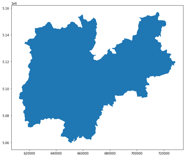
choose the province of Trento
province_of_trento = provincies[provincies['DEN_PROV']=='Trento']
province_of_trento
| COD_RIP | COD_REG | COD_PROV | COD_CM | COD_UTS | DEN_PROV | DEN_CM | DEN_UTS | SIGLA | TIPO_UTS | Shape_Leng | Shape_Area | geometry | |
|---|---|---|---|---|---|---|---|---|---|---|---|---|---|
| 21 | 2 | 4 | 22 | 0 | 22 | Trento | - | Trento | TN | Provincia autonoma | 594758.785501 | 6.208170e+09 | MULTIPOLYGON (((716676.337 5153931.623, 716029... |
plot it
province_of_trento.plot(figsize=(10,10))
plt.show()
2. load the shapefile of ISTAT with the informations of the muncipalities
identify the municipalities of the province selected with the biggest and smallest area
this means we need to use another layer / dataset
municipalities = gpd.read_file(url,layer="municipalities")
WARNING:fiona._env:File /vsimem/bff5372ff2dc43c3b114ee0fc1f5f392 has GPKG application_id, but non conformant file extension
municipalities.columns
Index(['COD_RIP', 'COD_REG', 'COD_PROV', 'COD_CM', 'COD_UTS', 'PRO_COM',
       'PRO_COM_T', 'COMUNE', 'COMUNE_A', 'CC_UTS', 'Shape_Leng', 'Shape_Area',
       'geometry'],
      dtype='object')
COD_RIP
codice ripartizione
numeric code of the macroregion of belonging
COD_REG
codice regione
numeric code of the region of belonging
COD_PROV
codice provincia
numeric code of the region of belonging
COD_CM
codice comune
unique numeric identification code of the municipality within the province of belonging
COD_UTS
codice unità territoriali sovracomunali
Numeric code that uniquely identifies the Units
territorial supra-municipal on the national territory.
PRO_COM
*provincia comune**
Numeric code that uniquely identifies the Municipality
on the national territory. (= COD_PROV & COD_COM)
PRO_COM_T
*provincia comune territorio**
Alphanumeric code that uniquely identifies the
Municipality on the national territory.
Like PRO_COM but definied in 6 fixed characters.
COMUNE
comune
Name of the Municipality
COMUNE_A
comune alternativa
Name of the Municipality in a language other than Italian
CC_UTS
comune capoluogo
Provincial capital or metropolitan city
1 => True
2 => False
the COD_PROV of the Province of Trento is 22
# filter the province
municipalities_province_trento = municipalities[municipalities.COD_PROV==22]
# plot it
municipalities_province_trento.plot(figsize=(10,10))
plt.show()

identify the cities of the province selected with the biggest and smallest area
CAUTION:
we are using generalized boundaries !!!
finding the max area
max_area = municipalities_province_trento.geometry.area.max()
max_area
199625902.75494903
finding the min area
min_area = municipalities_province_trento.geometry.area.min()
min_area
1652100.49475859
… you can obtain the same in another way (combination of the requests)
municipalities[municipalities.COD_PROV==22].geometry.area.min()
1652100.49475859
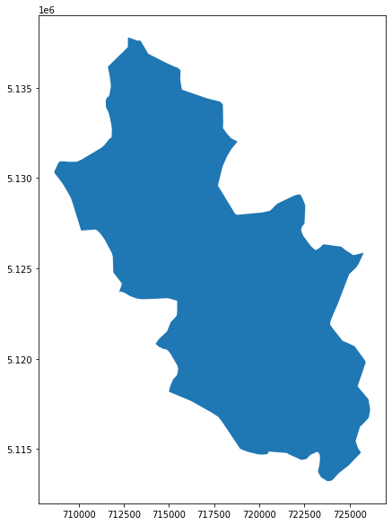
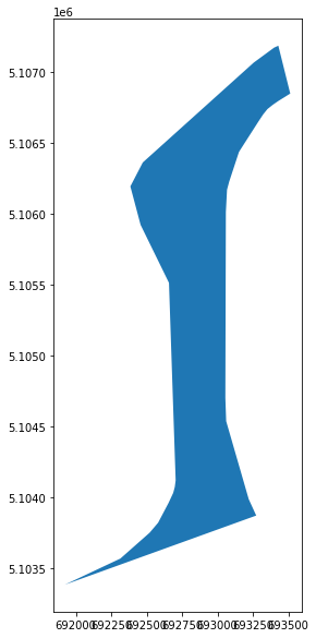
identify the municipality with the biggest area
maxarea_municipality_trentino = municipalities_province_trento[municipalities_province_trento.geometry.area == max_area]
maxarea_municipality_trentino.PRO_COM_T
3025    022245
Name: PRO_COM_T, dtype: object
maxarea_municipality_trentino.COMUNE
3025    Primiero San Martino di Castrozza
Name: COMUNE, dtype: object
the municipality with the bigger area is Primiero San Martino di Castrozza (022245)
maxarea_municipality_trentino.plot(figsize=(10,10))
plt.show()
identify the municipality with the smallest area
minarea_municipality_trentino = municipalities_province_trento[municipalities_province_trento.geometry.area == min_area]
minarea_municipality_trentino.COMUNE
2896    Carzano
Name: COMUNE, dtype: object
minarea_municipality_trentino.PRO_COM_T
2896    022043
Name: PRO_COM_T, dtype: object
the municipality with the smallest area is Carzano (022243)
minarea_municipality_trentino.plot(figsize=(10,10))
plt.show()
extract all the centroids of the areas expressed in WGS84
maxarea_municipality_trentino.geometry.centroid.to_crs(epsg=4326)
3025    POINT (11.82683 46.24190)
dtype: geometry
minarea_municipality_trentino.geometry.centroid.to_crs(epsg=4326)
2896    POINT (11.49436 46.07497)
dtype: geometry
extract a rappresenative point for the area of the smallest and bigger municipality in WGS84
representative_point_minarea_municipality = minarea_municipality_trentino.geometry.representative_point()
representative_point_maxarea_municipality = maxarea_municipality_trentino.geometry.representative_point()
representative_point_minarea_municipality.to_crs(epsg=4326)
2896    POINT (11.49403 46.07235)
dtype: geometry
representative_point_maxarea_municipality.to_crs(epsg=4326)
3025    POINT (11.83795 46.24792)
dtype: geometry
save the data in GeoJSON files
we can save each point in geojson
representative_point_maxarea_municipality.to_crs(epsg=4326).to_file("point.geojson",driver="GeoJSON")
… but we need to create an only one file with all the data in a geojson file
points = representative_point_maxarea_municipality.append(representative_point_minarea_municipality)
points.to_crs(epsg=4326).to_file("points.geojson",driver="GeoJSON")
and we can do the same with the polygons
polygons = maxarea_municipality_trentino.append(minarea_municipality_trentino)
polygons.to_crs(epsg=4326).to_file("polygons.geojson",driver="GeoJSON")
# you need to use this function only if you are working with Google Colab
# uncomment if you want use it
# from google.colab import files
#files.download("points.geojson")
<IPython.core.display.Javascript object>


<IPython.core.display.Javascript object>
#files.download("polygons.geojson")
<IPython.core.display.Javascript object>


<IPython.core.display.Javascript object>
tip 1:
you can download, open with geojson.io and create a gist resource to distribute
tip 2:
you can download the files and create a map with umap and create an interactive map online with the data
calculate the distance on the geodetic between the municipality with the big area and smallest area by using the centroid
to_point = minarea_municipality_trentino.geometry.centroid.values[0]
maxarea_municipality_trentino.geometry.centroid.distance(to_point)
3025    31686.63797
dtype: float64
distance = maxarea_municipality_trentino.geometry.centroid.distance(to_point).values[0]
distance
31686.637969815347
the distance is in meters due the CRS used on the dataset
to_city = minarea_municipality_trentino.COMUNE.values[0]
from_city = maxarea_municipality_trentino.COMUNE.values[0]
distance_km = distance/1000
print("the distance from %s to %s is %.1f km" % (from_city, to_city, round(distance_km,1)))
the distance from Primiero San Martino di Castrozza to Carzano is 31.7 km
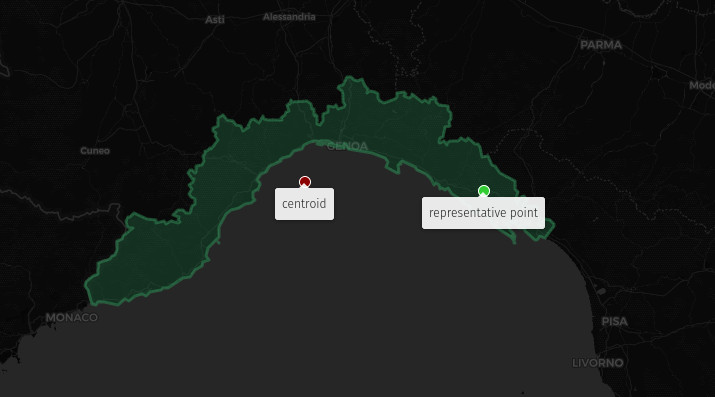
Why a representative point?
Where is the centroid of Liguria?
regions = gpd.read_file(url,layer="regions")
WARNING:fiona._env:File /vsimem/1023372f228c4f2f8ea69e6cbbc51fa5 has GPKG application_id, but non conformant file extension
regions.DEN_REG.unique()
array(['Piemonte', "Valle d'Aosta", 'Lombardia', 'Trentino-Alto Adige',
       'Veneto', 'Friuli Venezia Giulia', 'Liguria', 'Emilia-Romagna',
       'Toscana', 'Umbria', 'Marche', 'Lazio', 'Abruzzo', 'Molise',
       'Campania', 'Puglia', 'Basilicata', 'Calabria', 'Sicilia',
       'Sardegna'], dtype=object)
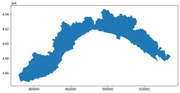
regions[regions.DEN_REG=='Liguria'].plot(figsize=(10,10))
plt.show()
regions[regions.DEN_REG=='Liguria'].to_crs(epsg=4326).to_file("liguria.geojson",driver='GeoJSON')
regions[regions.DEN_REG=='Liguria'].centroid.to_crs(epsg=4326).to_file("liguria_centroid.geojson",driver='GeoJSON')
regions[regions.DEN_REG=='Liguria'].representative_point().to_crs(epsg=4326).to_file("liguria_representative_point.geojson",driver='GeoJSON')
# uncomment if you want download from Colab
# files.download("liguria.geojson")
# uncomment if you want download from Colab
# files.download("liguria_centroid.geojson")
# uncomment if you want download from Colab
# files.download('liguria_representative_point.geojson')
you can upload all the geojson on uMap to see the result
3. download the shapefile of the lakes and bodies of water of Trentino
note: the shapefile is in Monte Mario 1
dataurl='https://github.com/napo/geospatial_course_unitn/raw/master/data/trentino/lakes_bodies_of_water_trentino.zip'
lakes_bodies_of_water_trentino = gpd.read_file(dataurl)
plot the geometries where Fktuso is “02”
lakes_bodies_of_water_trentino.head(3)
| OBJECTID | NOMESPACQ | geometry | |
|---|---|---|---|
| 0 | 29690.0 | LAGO DI MOLVENO | POLYGON ((1652079.952 5111676.932, 1652079.586... |
| 1 | 29743.0 | LAGO BACINO S.I.T. - BACINO DI PONTARSO | POLYGON ((1692832.012 5109957.392, 1692832.114... |
| 2 | 29723.0 | LAGO DEL CARESER | POLYGON ((1630312.511 5142839.286, 1630311.588... |
lakes_bodies_of_water_trentino.columns
Index(['OBJECTID', 'NOMESPACQ', 'geometry'], dtype='object')
where is “Fktuso” ???
We have to analyze the ESRI Shapefile
os.mkdir("shapefile")
os.chdir("shapefile")
urllib.request.urlretrieve(dataurl ,"lakes_bodies_of_water_trentino.zip")
('lakes_bodies_of_water_trentino.zip',
 <http.client.HTTPMessage at 0x7f5dcf5444d0>)
import zipfile
z = zipfile.ZipFile('lakes_bodies_of_water_trentino.zip')
z.extractall()
os.listdir()
['lakes_bodies_of_water_trentino_use.dbf',
 'lakes_bodies_of_water_trentino.shx',
 'lakes_bodies_of_water_trentino.zip',
 'lakes_bodies_of_water_trentino.dbf',
 'lakes_bodies_of_water_trentino.shp']
| filenname | description | note |
|---|---|---|
| lakes_bodies_of_water_trentino.shp | the file with the shapes (geometries) | ok |
| lakes_bodies_of_water_trentino_use.dbf | the file with the attributes | the name is NOT the same of the .shp |
| lakes_bodies_of_water_trentino.dbf | the file with the attributes | the name is the same of the .shp |
| lakes_bodies_of_water_trentino.zip | the zip archive | it’s present because downloaded |
| lakes_bodies_of_water_trentino.shx | the file to associate the attributes to the geometries | the name is the the of the .shp |
How we can use the file lakes_bodies_of_water_trentino_use.dbf?
Try to create a shapefile from the other
from shutil import copyfile
copyfile("lakes_bodies_of_water_trentino.shp","lakes_bodies_of_water_trentino_use.shp")
'lakes_bodies_of_water_trentino_use.shp'
copyfile("lakes_bodies_of_water_trentino.shx","lakes_bodies_of_water_trentino_use.shx")
'lakes_bodies_of_water_trentino_use.shx'
lakes_bodies_of_water_trentino_use = gpd.read_file("lakes_bodies_of_water_trentino_use.shp")
lakes_bodies_of_water_trentino_use.columns
Index(['FKTUSO', 'geometry'], dtype='object')
there is the attribute “FTKUSO” …
lakes_bodies_of_water_trentino_use.FKTUSO.unique()
array(['0101', '92', '0191', '0192', '02', '0102'], dtype=object)
… and there is also the value “02”
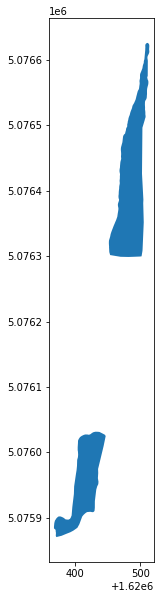
ftkuso02 = lakes_bodies_of_water_trentino_use[lakes_bodies_of_water_trentino_use.FKTUSO=='02']
ftkuso02.plot(figsize=(10,10))
plt.show()
convert in WGS84 and create a geojson
ftkuso02.to_crs(epsg=4326)
---------------------------------------------------------------------------

ValueError                                Traceback (most recent call last)

<ipython-input-84-cce14c4aa588> in <module>
----> 1 ftkuso02.to_crs(epsg=4326)


/usr/local/lib/python3.7/dist-packages/geopandas/geodataframe.py in to_crs(self, crs, epsg, inplace)
   1273         else:
   1274             df = self.copy()
-> 1275         geom = df.geometry.to_crs(crs=crs, epsg=epsg)
   1276         df.geometry = geom
   1277         df.crs = geom.crs


/usr/local/lib/python3.7/dist-packages/geopandas/geoseries.py in to_crs(self, crs, epsg)
   1118         """
   1119         return GeoSeries(
-> 1120             self.values.to_crs(crs=crs, epsg=epsg), index=self.index, name=self.name
   1121         )
   1122


/usr/local/lib/python3.7/dist-packages/geopandas/array.py in to_crs(self, crs, epsg)
    762         if self.crs is None:
    763             raise ValueError(
--> 764                 "Cannot transform naive geometries.  "
    765                 "Please set a crs on the object first."
    766             )


ValueError: Cannot transform naive geometries.  Please set a crs on the object first.
ERROR: Cannot transform naive geometries. Please set a crs on the object first.
The geodataframe is without the CRS
If you check again all the files contained in the zip archive the .prj file is not present!!!
You need to create it!
THe note says “projection Monte Mario zone 1”
This is enough to search the right epsg code on https://epsg.io with the query “Monte Mario 1”
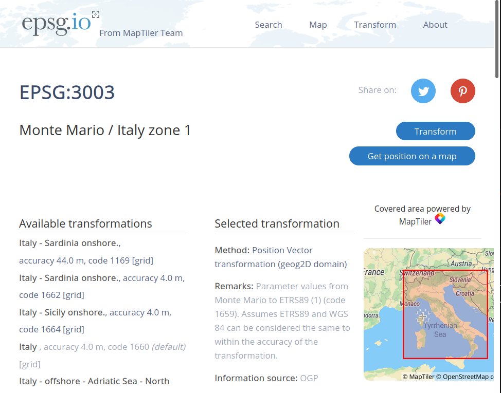
where the EPSG code is 3003
the solution can be possible in two ways:
1 - assign the CRS to the geodataframe
ftkuso02.set_crs(epsg=3003,inplace=True,allow_override=True)
| FKTUSO | geometry | |
|---|---|---|
| 43 | 02 | POLYGON ((1620506.057 5076599.354, 1620506.479... |
| 56 | 02 | POLYGON ((1620419.156 5075908.883, 1620417.568... |
ftkuso02.to_crs(epsg=4326)
| FKTUSO | geometry | |
|---|---|---|
| 43 | 02 | POLYGON ((10.55121 45.83224, 10.55122 45.83226... |
| 56 | 02 | POLYGON ((10.54992 45.82605, 10.54990 45.82604... |
this approach solves the problem but keeps the error in the data source.
Keeping this approach, it is advisable to apply the assignment of the CRS to the initial geodataframe and, if necessary, to export the geodatrafame in ESRi Shapefile (or other format)
2 - create a file with the name lakes_bodies_of_water_trentino_use.prj that contains the right string in WKT for the proj conversion.
You can obtain the right file by simple download the right string from epsg.io in this way
https://epsg.io/3003.wkt
simple by adding .wkt to the url
this is the answer
PROJCS["Monte Mario / Italy zone 1",
    GEOGCS["Monte Mario",
        DATUM["Monte_Mario",
            SPHEROID["International 1924",6378388,297,
                AUTHORITY["EPSG","7022"]],
            TOWGS84[-104.1,-49.1,-9.9,0.971,-2.917,0.714,-11.68],
            AUTHORITY["EPSG","6265"]],
        PRIMEM["Greenwich",0,
            AUTHORITY["EPSG","8901"]],
        UNIT["degree",0.0174532925199433,
            AUTHORITY["EPSG","9122"]],
        AUTHORITY["EPSG","4265"]],
    PROJECTION["Transverse_Mercator"],
    PARAMETER["latitude_of_origin",0],
    PARAMETER["central_meridian",9],
    PARAMETER["scale_factor",0.9996],
    PARAMETER["false_easting",1500000],
    PARAMETER["false_northing",0],
    UNIT["metre",1,
        AUTHORITY["EPSG","9001"]],
    AXIS["X",EAST],
    AXIS["Y",NORTH],
    AUTHORITY["EPSG","3003"]]
url = "https://epsg.io/3003.wkt"
opener = urllib.request.URLopener()
opener.addheader('User-Agent', 'Geospatial Course Unitn')
filename, headers = opener.retrieve(url, 'lakes_bodies_of_water_trentino_use.prj')
.. it’s better create a copy also for the original .shp file
copyfile("lakes_bodies_of_water_trentino_use.prj","lakes_bodies_of_water_trentino.prj")
'lakes_bodies_of_water_trentino.prj'
.. and now it’s necessary to recreate the geodataframe and repeat the operations
lakes_bodies_of_water_trentino_use = gpd.read_file("lakes_bodies_of_water_trentino_use.shp")
lakes_bodies_of_water_trentino_use.crs
<Projected CRS: EPSG:3003>
Name: Monte Mario / Italy zone 1
Axis Info [cartesian]:
- X[east]: Easting (metre)
- Y[north]: Northing (metre)
Area of Use:
- name: Italy - onshore and offshore - west of 12°E.
- bounds: (5.94, 36.53, 12.0, 47.04)
Coordinate Operation:
- name: Italy zone 1
- method: Transverse Mercator
Datum: Monte Mario
- Ellipsoid: International 1924
- Prime Meridian: Greenwich
Now it’s ok ;)
ftkuso02 = lakes_bodies_of_water_trentino_use[lakes_bodies_of_water_trentino_use.FKTUSO=='02']
… and create the geojson file in wgs84
ftkuso02.to_crs(epsg=4326).to_file("ftkuso02.geojson",driver="GeoJSON")
# uncomment if you want download from Colab
# files.download("ftkuso02.geojson")
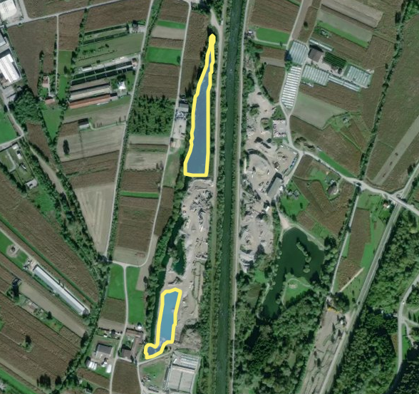
… and here the areas over a satellite image