Solution 03
Setup
you can use pygeos or rtree but you need to install before geopandas
try:
  import pygeos
except ModuleNotFoundError as e:
  !pip install pygeos==0.10.2
  import pygeos
try:
    import geopy
except ModuleNotFoundError as e:
    !pip install geopy==2.2.0
    import geopy
if geopy.__version__ != "2.2.0":
    !pip install -U geopy==2.2.0
    import geopy
try:
  import mapclassify
except ModuleNotFoundError as e:
  !pip install mapclassify=="2.4.3"
  import mapclassify
try:
  import geopandas as gpd
except ModuleNotFoundError as e:
  !pip install geopandas==0.10.2
  import geopandas as gpd
if gpd.__version__ != "0.10.2":
  !pip install -U geopandas==0.10.2
  import geopandas as gpd
try:
    import owslib
except ModuleNotFoundError as e:
    !pip install owslib==0.25.0
    import owslib

if owslib.__version__ != "0.25.0":
    !pip install -U owslib==0.25.0
    import owslib
try:
    import shapefile
except ModuleNotFoundError as e:
    !pip install pyshp==2.1.3
    import shapefile

if shapefile.__version__ != "2.1.3":
    !pip install -U pyshp==2.1.3
    import shapefile
import os
os.environ['RESTAPI_USE_ARCPY'] = 'FALSE'

try:
    import restapi
except ModuleNotFoundError as e:
    !pip install bmi-arcgis-restapi==2.1.2
    import restapi

if restapi.__version__ != "2.1.2":
    !pip install -U bmi-arcgis-restapi==2.1.2
    import restapi
Exercises
- identify the location of these address with a geocoder
- Piazza Castello, Udine
- Piazza Italia, Trento
- Piazza Foroni, Torino
- find the administrative border of “comunità di valle” (community of valley) of Province Autonomous of Trento
- identify all the rivers inside the smallest community of valley of Trentino
- repeat the same exercise with the layer “Comuni Terremotati” (municipalities affected by earthquake) of the italian Civil Protection by choosing the smallest municipality contained on the layer
Solutions
learning objectives
- repeat the concepts on the previous lesson
identify the location of these address with a geocoder
- Piazza Castello, Udine
- Piazza Italia, Trento
- Piazza Foroni, Torino
Piazza Castello, Udine
q="Piazza, Castello, Udine"
point = gpd.tools.geocode(q, provider="arcgis")
point.address[0]
'Piazza Castello, 33010, Colloredo di Monte Albano, Udine'
Colloredo di Monte Albano is a municipality of Friuli Venezia Giula in province of
We need to improve the query search because “Udine” is a municipality and also a (former) province.
q="Piazza, Castello, Udine, Udine"
point = gpd.tools.geocode(q, provider="arcgis")
point.address[0]
'Piazzale del Castello, 33100, Udine'
point.explore(marker_kwds={"color": "green", "radius": "10"})
this sounds right … but “Piazzale”
point_nominatim = gpd.tools.geocode(q,provider="Nominatim",user_agent="Example for the course")
point_nominatim.address[0]
'Piazza Longobardi, Castello, Majano, Udine, Friuli-Venezia Giulia, Italia'
Complety wrong!
q="Piazza, Castello, Udine, Udine"
There a comma to remove
q="Piazza Castello, Udine, Udine"
point_nominatim = gpd.tools.geocode(q,provider="Nominatim",user_agent="Example for the course")
point_nominatim.address[0]
'Piazza Castello, Laibacco, Colloredo di Monte Albano, Udine, Friuli-Venezia Giulia, Italia'
again wrong … investigate more values
q="Piazzale Castello, Udine, Udine"
point_nominatim = gpd.tools.geocode(q,provider="Nominatim",user_agent="Example for the course")
point_nominatim.address[0]
'Piazzale della Patria del Friuli, Borgo Gemona, Udine, Friuli-Venezia Giulia, 33100, Italia'
point_nominatim.explore(marker_kwds={"color": "green", "radius": "10"})
this looks right
More investigation
from geopy.geocoders import Nominatim
geolocator = Nominatim(user_agent="Example for the course")
more_values = geolocator.geocode(q,exactly_one=False)
more_values
[Location(Piazzale della Patria del Friuli, Borgo Gemona, Udine, Friuli-Venezia Giulia, 33100, Italia, (46.0647686, 13.235658516341397, 0.0))]
more_values[0].raw
{'place_id': 164989388,
 'licence': 'Data © OpenStreetMap contributors, ODbL 1.0. https://osm.org/copyright',
 'osm_type': 'way',
 'osm_id': 243637944,
 'boundingbox': ['46.0644445', '46.0651157', '13.2352794', '13.2360969'],
 'lat': '46.0647686',
 'lon': '13.235658516341397',
 'display_name': 'Piazzale della Patria del Friuli, Borgo Gemona, Udine, Friuli-Venezia Giulia, 33100, Italia',
 'class': 'landuse',
 'type': 'grass',
 'importance': 0.52}
Ok! This isn’t a square (piazza), this is an area around the castle of Udine
Piazza Italia, Trento
q="Piazza Italia, Trento"
point = gpd.tools.geocode(q, provider="arcgis")
point.address[0]
'Piazza, Terragnolo, Trento'
this sounds like “The main square (piazza) of the muncipality of Terragnolo in province of Trento”
… we can try to specify better the city and the province
q="Piazza Italia, Trento, Provincia di Trento"
point = gpd.tools.geocode(q, provider="arcgis")
point.address[0]
'Trento, Provincia di Trento'
point.explore(marker_kwds={"color": "green", "radius": "10"})
bad position: the point is good to represent Trento but not the square
change geocoder
point = gpd.tools.geocode(q, provider="nominatim",user_agent="Example for the course")
point.address[0]
'Piazza Italia, Villa Rendena, Porte di Rendena, Comunità delle Giudicarie, Provincia di Trento, Trentino-Alto Adige/Südtirol, 38979, Italia'
again wrong … add more details?
q="Piazza Italia, Centro Storico Trento, Trento, Provincia di Trento"
point = gpd.tools.geocode(q, provider="nominatim",user_agent="Example for the course")
point.address[0]
"Piazza Cesare Battisti, Bolghera, Centro storico Trento, Trento, Territorio Val d'Adige, Provincia di Trento, Trentino-Alto Adige/Südtirol, Italia"
point.explore(marker_kwds={"color": "green", "radius": "10"})
this sounds right but … this is Piazza Cesare Battisti
Note:
Piazza Italia is the former name of Piazza Cesare Battisti
Piazza Foroni, Torino
q="Piazza, Foroni, Torino, Torino"
point = gpd.tools.geocode(q, provider="arcgis")
point.address[0]
'Via Jacopo Foroni, 10154, Torino'
“Via” means “Street”. Mistake or this is close to a square with the same name?
point.explore(marker_kwds={"color": "green", "radius": "10"})
q="Piazza, Foroni, Torino, Torino"
point = gpd.tools.geocode(q, provider="nominatim",user_agent="Example for the course")
point.address[0]
'Mercato di Piazza Foroni, Piazza Jacopo Foroni, Monte Rosa, Circoscrizione 6, Torino, Piemonte, 10154, Italia'
point.explore(marker_kwds={"color": "green", "radius": "10"})
find the administrative border of “comunità di valle” (community of valley) of Province Autonomous of Trento
from owslib.csw import CatalogueServiceWeb
from owslib.fes import PropertyIsLike
import geopandas as gpd
from matplotlib import pyplot as plt
We start from the italian national repository - http://geodati.gov.it
csw = CatalogueServiceWeb("http://geodati.gov.it/RNDT/csw")
query = PropertyIsLike('csw:AnyText', 'Comunità di valle')
csw.getrecords2(constraints=[query],maxrecords=5)
for rec in csw.records:
  print(rec + " - " + csw.records[rec].title)
p_bi:4c07e84b-088e-488f-a144-5dabb3c4b6d0 - Provincia di Biella - vegetazione della Valle Elvo
p_TN:58604ed2-ac1d-4f78-a00c-514fd3562c51 - Limite Comunità di valle
r_emiro:2015-06-04T161431 - Itinerari geologico-ambientali nella Valle del Marecchia
r_abruzz:00047:20091110:151939 - Comunità Montane Regione Abruzzo
r_lombar:000028:20211130:115710 - Carta Ittica Regionale - WMS
id_record="p_TN:58604ed2-ac1d-4f78-a00c-514fd3562c51"
record = csw.records[id_record]
record.abstract
"Rappresenta il limite delle Comunità di valle, le quali sono enti pubblici locali a struttura associativa costituiti obbligatoriamente dai comuni compresi in ciascun territorio individuato ai sensi dell'art.12 comma 2 (LP3-2006 art 14 comma2) ad esse e ai Comuni di Trento e Rovereto sono trasferite numerose competenze che ora sono in capo alla Provincia, ovviamente fatte salve le competenze dei comuni e delle amministrazioni separate dei beni di usi civico.Intesa tra la Provincia e il Consiglio delle Autonomie locali approvato nella seduta del 16 marzo 2007 concernente Individuazione dei territori delle Comunità ai sensi dell'articolo 12 della legge provinciale 16 giugno 2006, n. 3 (Norme in materia di governo dell'autonomia del Trentino).NB: PER LA TABELLA DEGLI ATTRIBUTI E' STATO UTILIZZATO IL SET DI CARATTERI UNICODE UTF-8"
for reference in record.references:
  print(reference['scheme'])
  print(reference['url'])
urn:x-esri:specification:ServiceType:ArcIMS:Metadata:Server
http://www.territorio.provincia.tn.it
urn:x-esri:specification:ServiceType:ArcIMS:Metadata:Server
https://idt.provincia.tn.it/idt/vector/p_TN_58604ed2-ac1d-4f78-a00c-514fd3562c51.zip
urn:x-esri:specification:ServiceType:ArcIMS:Metadata:Document
https://geodati.gov.it/geoportalRNDTPA/csw?getxml=%7B995A9C38-26FD-4564-8539-68744B2A46D2%7D
valley_communities = gpd.read_file('https://siat.provincia.tn.it/IDT/vector/public/p_tn_58604ed2-ac1d-4f78-a00c-514fd3562c51.zip')
valley_communities.head(5)
| objectid | classid | sede | nome | struttura | struttura_ | dataini | datafine | fkfonte | fktfonte_d | fktipoelab | fktipoel_d | fkscala | fkscala_d | geometry | |
|---|---|---|---|---|---|---|---|---|---|---|---|---|---|---|---|
| 0 | 181 | AMB002_14 | ANDALO | COMUNITÀ DELLA PAGANELLA | S133 | Servizio Catasto | 2020/01/01 00:00:00.000 | None | 05 | altre fonti | 01 | manuale | 03 | 10000 | POLYGON ((659718.849 5118603.995, 659717.453 5... |
| 1 | 182 | AMB002_8 | TIONE DI TRENTO | COMUNITÀ DELLE GIUDICARIE | S133 | Servizio Catasto | 2020/01/01 00:00:00.000 | None | 05 | altre fonti | 01 | manuale | 03 | 10000 | POLYGON ((626847.878 5074565.314, 626878.525 5... |
| 2 | 183 | AMB002_12 | LAVARONE | MAGNIFICA COMUNITÀ DEGLI ALTIPIANI CIMBRI | S133 | Servizio Catasto | 2020/01/01 00:00:00.000 | None | 05 | altre fonti | 01 | manuale | 03 | 10000 | POLYGON ((675134.859 5087715.705, 675136.500 5... |
| 3 | 184 | AMB002_15 | TRENTO | TERRITORIO VAL D'ADIGE | S133 | Servizio Catasto | 2020/01/01 00:00:00.000 | None | 05 | altre fonti | 01 | manuale | 03 | 10000 | POLYGON ((663458.060 5094288.411, 663453.437 5... |
| 4 | 185 | AMB002_1 | CAVALESE | COMUNITÀ TERRITORIALE DELLA VAL DI FIEMME | S133 | Servizio Catasto | 2020/01/01 00:00:00.000 | None | 05 | altre fonti | 01 | manuale | 03 | 10000 | POLYGON ((681770.000 5126270.500, 681789.000 5... |
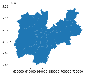
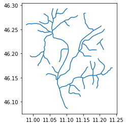
valley_communities.plot()
plt.show()
valley_communities.head(5)
| objectid | classid | sede | nome | struttura | struttura_ | dataini | datafine | fkfonte | fktfonte_d | fktipoelab | fktipoel_d | fkscala | fkscala_d | geometry | |
|---|---|---|---|---|---|---|---|---|---|---|---|---|---|---|---|
| 0 | 181 | AMB002_14 | ANDALO | COMUNITÀ DELLA PAGANELLA | S133 | Servizio Catasto | 2020/01/01 00:00:00.000 | None | 05 | altre fonti | 01 | manuale | 03 | 10000 | POLYGON ((659718.849 5118603.995, 659717.453 5... |
| 1 | 182 | AMB002_8 | TIONE DI TRENTO | COMUNITÀ DELLE GIUDICARIE | S133 | Servizio Catasto | 2020/01/01 00:00:00.000 | None | 05 | altre fonti | 01 | manuale | 03 | 10000 | POLYGON ((626847.878 5074565.314, 626878.525 5... |
| 2 | 183 | AMB002_12 | LAVARONE | MAGNIFICA COMUNITÀ DEGLI ALTIPIANI CIMBRI | S133 | Servizio Catasto | 2020/01/01 00:00:00.000 | None | 05 | altre fonti | 01 | manuale | 03 | 10000 | POLYGON ((675134.859 5087715.705, 675136.500 5... |
| 3 | 184 | AMB002_15 | TRENTO | TERRITORIO VAL D'ADIGE | S133 | Servizio Catasto | 2020/01/01 00:00:00.000 | None | 05 | altre fonti | 01 | manuale | 03 | 10000 | POLYGON ((663458.060 5094288.411, 663453.437 5... |
| 4 | 185 | AMB002_1 | CAVALESE | COMUNITÀ TERRITORIALE DELLA VAL DI FIEMME | S133 | Servizio Catasto | 2020/01/01 00:00:00.000 | None | 05 | altre fonti | 01 | manuale | 03 | 10000 | POLYGON ((681770.000 5126270.500, 681789.000 5... |
identify all the rivers inside the smallest community of valley of Trentino
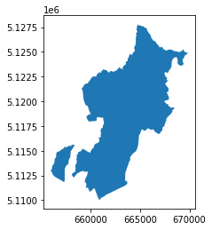
identify the smallest community of valley
smallest_community = valley_communities[valley_communities.area == valley_communities.area.min()]
smallest_community
| objectid | classid | sede | nome | struttura | struttura_ | dataini | datafine | fkfonte | fktfonte_d | fktipoelab | fktipoel_d | fkscala | fkscala_d | geometry | |
|---|---|---|---|---|---|---|---|---|---|---|---|---|---|---|---|
| 10 | 191 | AMB002_13 | MEZZOCORONA | COMUNITÀ ROTALIANA-KÖNIGSBERG | S133 | Servizio Catasto | 2020/01/01 00:00:00.000 | None | 05 | altre fonti | 01 | manuale | 03 | 10000 | MULTIPOLYGON (((656059.164 5112838.836, 656030... |
smallest_community.nome
10    COMUNITÀ ROTALIANA-KÖNIGSBERG
Name: nome, dtype: object
smallest_community.plot()
plt.show()
smallest_community.explore()
find a layer with the rivers for the area
identify the bounding box
smallest_community.to_crs(epsg=4326).bounds
| minx | miny | maxx | maxy | |
|---|---|---|---|---|
| 10 | 11.019439 | 46.12501 | 11.203875 | 46.283791 |
bbox = list(smallest_community.to_crs(epsg=4326).bounds.values[0])
bbox
[11.01943938362622, 46.12500990155531, 11.203874962508163, 46.283790799274264]
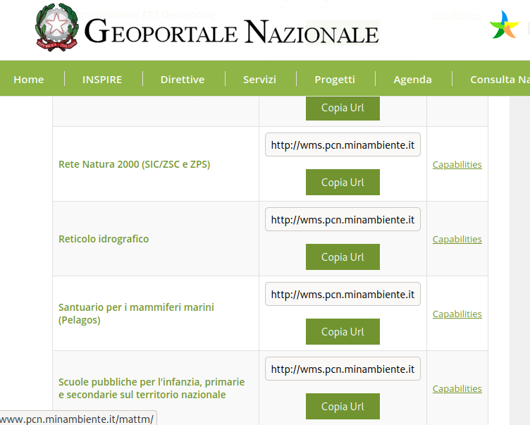
in this case we can use the WFS of the national cartographic portal of the Italian Ministry of the Environment
csw = CatalogueServiceWeb("http://www.pcn.minambiente.it/geoportal/csw")
[ … ]
from owslib.wfs import WebFeatureService
wfs_url="http://wms.pcn.minambiente.it/ogc?map=/ms_ogc/wfs/Aste_fluviali.map"
wfs = WebFeatureService(url=wfs_url,version="1.1.0")
wfs.identification.title
'Reticolo idrografico'
wfs.contents
{'ID.RETICOLO.FIUMI_PRINCIPALI_SECONDARI': <owslib.feature.wfs110.ContentMetadata at 0x7f23f2ed3370>,
 'ID.RETICOLO.FIUMI_TORRENTI': <owslib.feature.wfs110.ContentMetadata at 0x7f23f2ed3130>,
 'ID.RETICOLO.CORSI_ACQUA': <owslib.feature.wfs110.ContentMetadata at 0x7f23f2ed3220>,
 'ID.RETICOLO.ELEMENTI_IDRICI': <owslib.feature.wfs110.ContentMetadata at 0x7f23f2cd2710>}
layer = list(wfs.contents)[2]
response = wfs.getfeature(typename=layer, bbox=bbox,srsname='urn:ogc:def:crs:EPSG::4326')
rivers = gpd.read_file(response)
rivers.head(3)
| gml_id | id_fiume | id_tratta | tipo | nome | foglio_igm | sottotipo | ordine | bacino_pri | bacino | da | tipo_da | a | tipo_a | annotazion | enabled | geometry | |
|---|---|---|---|---|---|---|---|---|---|---|---|---|---|---|---|---|---|
| 0 | ID.RETICOLO.CORSI_ACQUA.9878 | 2241 | 11503 | BOLZANO | 1 | 3 | ADIGE | SORGENTE | 1 | NOCE | 3 | 1 | LINESTRING (46.17313 11.05670, 46.17069 11.060... | ||||
| 1 | ID.RETICOLO.CORSI_ACQUA.16150 | 688 | 14645 | BOLZANO | 1 | 2 | ADIGE | SORGENTE | 1 | ADIGE | 3 | 1 | LINESTRING (46.15510 11.03917, 46.15664 11.041... | ||||
| 2 | ID.RETICOLO.CORSI_ACQUA.20273 | 885 | 21041 | TORRENTE | AVISIO | BOLZANO | 1 | 2 | ADIGE | 19357 | 3 | 21042 | 3 | 1 | LINESTRING (46.17089 11.23801, 46.17053 11.237... |
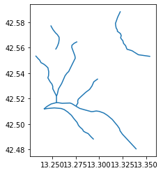
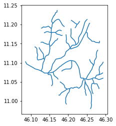
rivers.plot()
plt.show()
geometry_smallest_community_4326 = smallest_community.geometry.to_crs(epsg=4326).values[0]
rivers.within(geometry_smallest_community_4326).unique()
array([False])
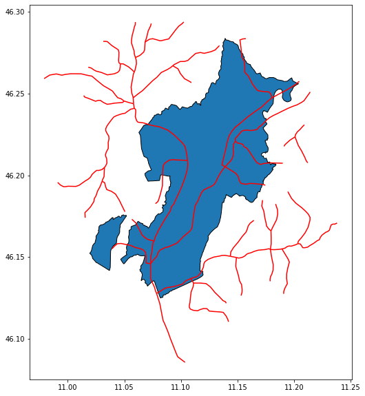
ax = smallest_community.to_crs(4326).plot(edgecolor='k',figsize=(15, 10))
rivers.plot(ax=ax,color="red")
plt.show()
there the problem of the inverted axes
It can ben solved with this function
import shapely
def swapxy(geometry):
  geometry = shapely.ops.transform(lambda x, y: (y, x),geometry)
  return geometry
rivers['geometry'] = rivers['geometry'].apply(lambda geometry: swapxy(geometry))
rivers.plot()
plt.show()
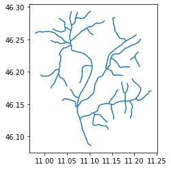
we are ready to plot on a map
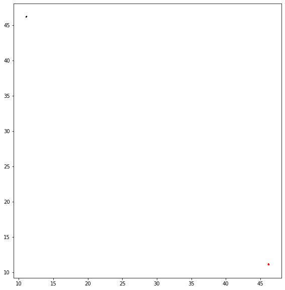
y = rivers.unary_union.centroid.y
x = rivers.unary_union.centroid.x
y
46.20213279893027
x
11.110945030023714
ax = smallest_community.to_crs(4326).plot(edgecolor='k',figsize=(15, 10))
rivers.plot(ax=ax,color="red")
plt.show()
CLIP
we need to have all the rivers inside the area and not the bounding box
gpd.clip(rivers, smallest_community)
/tmp/ipykernel_19093/3880772484.py:1: UserWarning: CRS mismatch between the CRS of left geometries and the CRS of right geometries.
Use `to_crs()` to reproject one of the input geometries to match the CRS of the other.

Left CRS: EPSG:4326
Right CRS: EPSG:25832

  gpd.clip(rivers, smallest_community)
| gml_id | id_fiume | id_tratta | tipo | nome | foglio_igm | sottotipo | ordine | bacino_pri | bacino | da | tipo_da | a | tipo_a | annotazion | enabled | geometry |
|---|
the geodatamews have to use the same projection
rivers_rotaliana = gpd.clip(rivers.to_crs(epsg=4326), smallest_community.to_crs(epsg=4326))
rivers.plot()
plt.show()
rivers_rotaliana.plot()
plt.show()
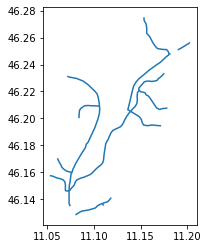
show the rivers on the map
rivers.explore()
repeat the same exercise
with the layer “Comuni Terremotati” (municipalities affected by earthquake) of the italian Civil Protection by choosing the smallest municipality contained on the layer
import os
os.environ['RESTAPI_USE_ARCPY'] = 'FALSE'
import restapi
rest_url = 'https://services6.arcgis.com/L1SotImj1AAZY1eK/ArcGIS/rest/services'
ags = restapi.ArcServer(rest_url)
agc_service_name = ""
for service in ags.services:
  if service.name == 'Comuni_Terremotati':
    agc_service_name = service.name
    print(service.name)
Comuni_Terremotati
ags_service = ags.getService(agc_service_name)
ags_service.list_layers()
['comuni_terremotatiDD']
municipalities_affected_earthquake = ags_service.layer('comuni_terremotatiDD')
we can ask ArcGIS RestAPI to transform the source from the native projection to the EPSG:25832
municipalities_affected_earthquake.export_layer('municipalities_affected_earthquake.shp', outSR=25832)
Created: "municipalities_affected_earthquake.shp"


'municipalities_affected_earthquake.shp'
geo_municipalities_affected_earthquake = gpd.read_file('municipalities_affected_earthquake.shp')
geo_municipalities_affected_earthquake.geometry
0     POLYGON ((825823.37496 4744509.99999, 825831.8...
1     POLYGON ((822188.87502 4732801.00004, 822431.1...
2     POLYGON ((836677.62503 4755035.49995, 838169.8...
3     POLYGON ((832493.43752 4758168.99995, 833177.3...
4     POLYGON ((858381.68751 4751289.99998, 858884.9...
5     POLYGON ((849760.43751 4750082.49996, 849960.9...
6     POLYGON ((846041.81249 4765923.99998, 846232.9...
7     POLYGON ((856514.06245 4756609.99998, 856643.0...
8     POLYGON ((850434.12498 4761464.99995, 850516.5...
9     POLYGON ((850348.12500 4740939.49997, 850545.4...
10    POLYGON ((856495.18747 4734432.49994, 856419.9...
11    POLYGON ((832470.37500 4704205.50001, 832598.1...
12    POLYGON ((860575.24996 4723655.50002, 860818.4...
13    POLYGON ((853776.93752 4720760.50001, 853849.4...
14    POLYGON ((845010.24996 4723371.99999, 845251.4...
15    POLYGON ((873001.31246 4740017.50004, 873145.9...
16    POLYGON ((871474.12497 4750509.50001, 871638.4...
Name: geometry, dtype: geometry
the values of the coordinates seems to be in meters
geo_municipalities_affected_earthquake.crs
<Geographic 2D CRS: EPSG:4326>
Name: WGS 84
Axis Info [ellipsoidal]:
- Lat[north]: Geodetic latitude (degree)
- Lon[east]: Geodetic longitude (degree)
Area of Use:
- name: World.
- bounds: (-180.0, -90.0, 180.0, 90.0)
Datum: World Geodetic System 1984 ensemble
- Ellipsoid: WGS 84
- Prime Meridian: Greenwich
.. but the CRS is EPSG:426 … we need to rewrite it!!!
geo_municipalities_affected_earthquake = geo_municipalities_affected_earthquake.set_crs(epsg=25832,allow_override=True)
geo_municipalities_affected_earthquake.crs
<Derived Projected CRS: EPSG:25832>
Name: ETRS89 / UTM zone 32N
Axis Info [cartesian]:
- E[east]: Easting (metre)
- N[north]: Northing (metre)
Area of Use:
- name: Europe between 6°E and 12°E: Austria; Belgium; Denmark - onshore and offshore; Germany - onshore and offshore; Norway including - onshore and offshore; Spain - offshore.
- bounds: (6.0, 38.76, 12.0, 84.33)
Coordinate Operation:
- name: UTM zone 32N
- method: Transverse Mercator
Datum: European Terrestrial Reference System 1989 ensemble
- Ellipsoid: GRS 1980
- Prime Meridian: Greenwich
Now is ok!
geo_municipalities_affected_earthquake.explore()
minarea = geo_municipalities_affected_earthquake.geometry.area.min()
minarea
30665483.55191904
smallest_municipality = geo_municipalities_affected_earthquake[geo_municipalities_affected_earthquake.geometry.area == minarea]
smallest_municipality.plot()
plt.show()
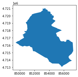
smallest_municipality.explore()
smallest_municipality.COMUNE
13    Capitignano
Name: COMUNE, dtype: object
we can use the same WFS resource used before with the new bounding box
bbox= list(smallest_municipality.to_crs(epsg=4326).bounds.values[0])
response = wfs.getfeature(typename=layer, bbox=bbox,srsname='urn:ogc:def:crs:EPSG::4326')
rivers_capitignano = gpd.read_file(response)
rivers_capitignano.plot()
plt.show()
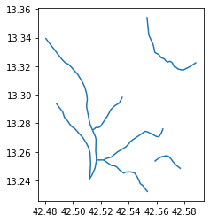
… and we need always to invert the axes
rivers_capitignano['geometry'] = rivers_capitignano['geometry'].apply(lambda geometry: swapxy(geometry))
rivers_capitignano.plot()
plt.show()