Solution 05
Setup
import pandas as pd
import requests
import warnings
warnings.filterwarnings('ignore')
from pandas.core.common import SettingWithCopyWarning
warnings.simplefilter(action="ignore", category=SettingWithCopyWarning)
try:
import pygeos
except ModuleNotFoundError as e:
!pip install pygeos==0.13
import pygeos
try:
import mapclassify
except ModuleNotFoundError as e:
!pip install mapclassify
import mapclassify
if mapclassify.__version__ != "2.4.3":
!pip install -U mapclassify==2.4.3
try:
import geopandas as gpd
except ModuleNotFoundError as e:
!pip install geopandas==0.12.1
import geopandas as gpd
if gpd.__version__ != "0.12.1":
!pip install -U geopandas==0.12.1
import geopandas as gpd
try:
import pyrosm
except ModuleNotFoundError as e:
!pip install pyrosm==0.6.1
import pyrosm
try:
import osmnx as ox
except ModuleNotFoundError as e:
!pip install osmnx==1.2.2
import osmnx as ox
if ox.__version__ != "1.2.2":
!pip install -U osmnx==1.2.2
import osmnx as ox
import pandas as pd
from matplotlib import pyplot as plt
Exercise
- identify the shortest path by walking to reach the Castle of Trento from the main train station of Trento
- identify the streets network orientation of the cities: Trento-Italy, Verona-Italy, Munich-Germany, Athens-Greece
- locate the student residences of Trento in OpenStreetMap and identify services in an area of 15 minutes based on the concept of Carlos Moreno of the 15 minute city
“…a way to ensure that urban residents can fulfill six essential functions within a 15-minute walk [or bike] from their dwellings: living, working, commerce, healthcare, education and entertainment…”
You are free to use OSMnx, Pyrosm with networkx or pandas or igraph
identify the shortest path by walk to reach the Castle of Trento from the main train station
- where is the castle in Trento
- where is the main train station
where is the castle in Trento
THe name of the castle of Trento is Castello del Buonconsiglio
from geopy.geocoders import Nominatim
geolocator = Nominatim(user_agent="geospatial course")
location = geolocator.geocode("Museo del Castello del Buonconsiglio")
point_castle = (location.latitude, location.longitude)
where is the main train station in Trento?
https://en.wikipedia.org/wiki/Trento_railway_station
location = geolocator.geocode("Piazza Dante 9, Trento")
point_train_station = (location.latitude, location.longitude)
download the data for PyrOSM
url_download_trento_pbf = 'https://osmit-estratti.wmcloud.org/dati/poly/comuni/pbf/022205_Trento_poly.osm.pbf'
import urllib.request
urllib.request.urlretrieve(url_download_trento_pbf ,"trento_osm.pbf")
osm = pyrosm.OSM("trento_osm.pbf")
create the streets walking graph
nodes, edges = osm.get_network(network_type="walking", nodes=True)
with networkx
network_onx = osm.to_graph(nodes, edges, graph_type="networkx")
%time
CPU times: user 4 µs, sys: 1e+03 ns, total: 5 µs
Wall time: 7.63 µs
point_nearest_train_station = ox.distance.nearest_nodes(network_onx,Y=point_train_station[0],X=point_train_station[1])
point_nearest_castle = ox.distance.nearest_nodes(network_onx,Y=point_castle[0],X=point_castle[1])
calculate the shortest path
shortest_path = ox.shortest_path(network_onx, point_nearest_train_station, point_nearest_castle, weight="length")
show it on the map
from shapely.geometry import Point, LineString
# function to create the route from the ids of the nodes
def route_nodes_to_line_networkx(nodelist, network,solution=1):
points = []
for idnode in nodelist:
lon = network.nodes[idnode]['x']
lat = network.nodes[idnode]['y']
point = Point(lon,lat)
points.append(point)
path = LineString(points)
route = gpd.GeoDataFrame(
{"src_node": [nodelist[0]], "tgt_node": [nodelist[-1]], "solution": [solution]},
geometry=[path],
crs="epsg:4326"
)
return route
route_with_onx = route_nodes_to_line_networkx(shortest_path, network_onx)
route_with_onx
| src_node | tgt_node | solution | geometry | |
|---|---|---|---|---|
| 0 | 2591984564 | 6036162196 | 1 | LINESTRING (11.11953 46.07204, 11.11957 46.072... |
route_with_onx.explore()
import fiona
fiona.drvsupport.supported_drivers['KML'] = 'rw'
route_with_onx.to_file("path_trainstation2castle_trento.kml", driver="KML")
.. and now you can visualize it with Google Earth
paths = ox.k_shortest_paths(network_onx, point_nearest_train_station, point_nearest_castle, k=10, weight="distance")
i = 0
gdf_paths = gpd.GeoDataFrame()
for path in paths:
new_route = route_nodes_to_line_networkx(path, network_onx,solution=str(i))
if i == 0:
gdf_paths = new_route
else:
gdf_paths = gdf_paths.append(new_route)
i += 1
gdf_paths.explore(column='solution',cmap="tab10",tiles="Stamen Toner")
gdf_paths[gdf_paths.solution == "0"].explore()
gdf_paths[gdf_paths.solution == "1"].explore()
gdf_paths[gdf_paths.solution == "2"].explore()
with igraph
nodes, edges = osm.get_network(nodes=True, network_type="walking")
network_igraph = osm.to_graph(nodes, edges,graph_type='igraph')
from shapely.ops import nearest_points
# look code solutions of lesson 2
def get_nearest_id(id, points):
# Create a union of points (multipoint geometry
multipoints = points[points.id != id]["geometry"].unary_union
# identify the starting point
point = points[points.id == id]
# find the nearest points
nearest_geoms = nearest_points(point['geometry'].values[0], multipoints)
# get corresponding values of the nearest point
# note: in the position 0 there is the starting point
nearest_data = points[points["geometry"] == nearest_geoms[1]]
# extract the id of the nearest point
nearest_id = nearest_data['id'].values[0]
return (nearest_id)
# create geodaframe
node_ids = []
ids = []
points = []
for v in network_igraph.vs:
node_id = v['node_id']
id = v['id']
p = Point(v['lon'],v['lat'])
ids.append(id)
points.append(p)
node_ids.append(node_id)
data = {}
data['id'] = ids
data['node_id'] = node_ids
data['geometry'] = points
gdf_vertex = gpd.GeoDataFrame(data,crs="epsg:4326")
multipoints = gdf_vertex.unary_union
point_trainstation = Point(point_train_station[1],point_train_station[0])
point_castle = Point(point_castle[1],point_castle[0])
nearest_geoms_train = nearest_points(point_trainstation, multipoints)
nearest_geoms_castle = nearest_points(point_castle, multipoints)
pstation = gdf_vertex[gdf_vertex.geometry == nearest_geoms_train[1]]
pcastle = gdf_vertex[gdf_vertex.geometry == nearest_geoms_castle[1]]
pstation
| id | node_id | geometry | |
|---|---|---|---|
| 39180 | 2591984564 | 39180 | POINT (11.11953 46.07204) |
idnodes_path = network_igraph.get_shortest_paths(pstation.node_id.values[0],to=pcastle.node_id.values[0])[0]
gdf_nodes_path = gdf_vertex[gdf_vertex.node_id.isin(idnodes_path)]
gdf_nodes_path.explore(marker_kwds={"color": "green", "radius": "10"})
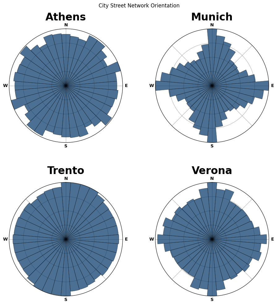
identify the streets network orientation of this list of cities
Trento-Italy, Verona-Italy, Munich-Germany, Athens-Greece
The suggestion is to read the blog Street Network Orientation post of Geoff Boeing (author of OSMnx) and adapt also che script present in the examples section on the OSMnx github repository.
From the script you have simple to change the names of the cities … and .. understand the code.
# define the study sites as label : query
places = {
'Trento' : "Trento, Territorio Val d'Adige, Provincia di Trento, Trentino-Alto Adige/Südtirol, Italy",
"Verona": "Verona, Veneto, Italy",
"Munich": "Munich, Bavaria, Germany",
"Athens": "Περιφερειακή Ενότητα Κεντρικού Τομέα Αθηνών"
}
# verify OSMnx geocodes each query to what you expect (i.e., a [multi]polygon geometry)
gdf = ox.geocode_to_gdf(list(places.values()))
gdf
| geometry | bbox_north | bbox_south | bbox_east | bbox_west | place_id | osm_type | osm_id | lat | lon | display_name | class | type | importance | |
|---|---|---|---|---|---|---|---|---|---|---|---|---|---|---|
| 0 | POLYGON ((11.02247 46.05027, 11.02296 46.05019... | 46.153011 | 45.977531 | 11.194823 | 11.022474 | 297532930 | relation | 46663 | 46.066423 | 11.125760 | Trento, Territorio Val d'Adige, Provincia di T... | boundary | administrative | 1.932529 |
| 1 | POLYGON ((10.87685 45.46084, 10.87712 45.46017... | 45.541837 | 45.349440 | 11.123900 | 10.876851 | 297101238 | relation | 44830 | 45.438496 | 10.992412 | Verona, Veneto, Italy | boundary | administrative | 0.976157 |
| 2 | MULTIPOLYGON (((11.36078 48.15807, 11.36085 48... | 48.248116 | 48.061624 | 11.722910 | 11.360777 | 297759456 | relation | 62428 | 48.137108 | 11.575382 | Munich, Bavaria, Germany | boundary | administrative | 1.076211 |
| 3 | POLYGON ((23.68700 37.97844, 23.68749 37.97825... | 38.059134 | 37.915813 | 23.823200 | 23.687005 | 298197509 | relation | 2604796 | 37.987486 | 23.740311 | Regional Unit of Central Athens, Attica, Greece | boundary | administrative | 0.419111 |
gdf.explore()
https://www.oraask.com/wiki/draw-a-polar-histogram-in-matplotlib
# import numpy as np
# n = len(places)
# ncols = int(np.ceil(np.sqrt(n)))
# nrows = int(np.ceil(n / ncols))
# figsize = (ncols * 5, nrows * 5)
# fig, axes = plt.subplots(nrows, ncols, figsize=figsize, subplot_kw={"projection": "polar"})
# # plot each city's polar histogram
# for ax, place in zip(axes.flat, sorted(places.keys())):
# print(ox.utils.ts(), place)
# # get undirected graphs with edge bearing attributes
# G = ox.graph_from_place(place, network_type="drive")
# Gu = ox.add_edge_bearings(ox.get_undirected(G))
# fig, ax = ox.bearing.plot_orientation(Gu, ax=ax, title=place, area=True)
# # add figure title and save image
# suptitle_font = {
# "family": "Arial",
# "fontsize": 60,
# "fontweight": "normal",
# "y": 1,
# }
# fig.suptitle("City Street Network Orientation") #, **suptitle_font)
# fig.tight_layout()
# fig.subplots_adjust(hspace=0.35)
# fig.savefig("street-orientations.png", facecolor="w", dpi=100, bbox_inches="tight")
# plt.close()
Here the result
.. and here the result for all the main cities of Italy
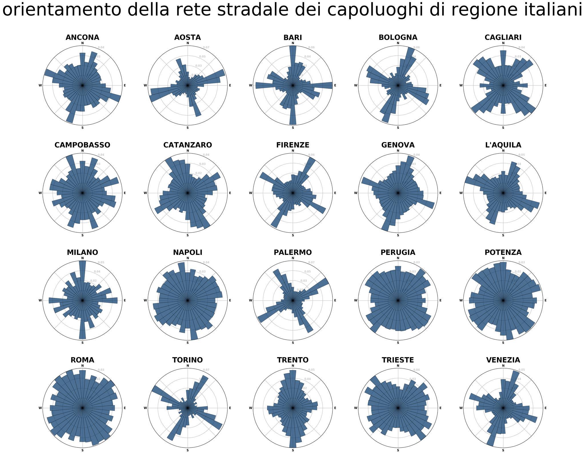
Vladimir Agafonkin created the web verson

https://mourner.github.io/road-orientation-map/#13.49/45.43646/12.33136
Here a simple map with the information of some cities in Trentino long the river Adige.

http://umap.openstreetmap.fr/en/map/orientamento-comuni-valle-delladige_234308#11/45.9588/11.1295
locate the student residences of Trento in OpenStreetMap and identify services in an area of 15 minutes based on the concept of Carlos Moreno of the 15 minute city
“…a way to ensure that urban residents can fulfill six essential functions within a 15-minute walk [or bike] from their dwellings: living, working, commerce, healthcare, education and entertainment…”
Data from OpenStreetMap
identify the tags for:
- commerce:
- building = commercial, industrial, kiosk, retail, supermarket, warehouse
- shop = *
- amenity = bar, pub, cafe, restaurant, fast_food, food_court, ice_cream
- healthcare
- amenity = baby_hatch,clinic,dentist, doctors, hospital, nursing_home, pharmacy, social_facility, veterinary
- education
- amenity = college, driving_school, kindergarten, language_school, library, toy_library, training, music_school, university
- entertainment
- amenity = arts_centre, cinema, community_centre, events_venue, fountain, social_facility, gambling, planetarium, public_bookcase, social_centre, studio, theatre
- living
- amenity = courthouse, fire_station, police, post_box, post_office, ranger_station, townhall
buildings = ox.geometries.geometries_from_place("Trento, Territorio Val d'Adige, Provincia di Trento, Trentino-Alto Adige/Südtirol, Italy", tags = {'building': True})
amenities = ox.geometries.geometries_from_place("Trento, Territorio Val d'Adige, Provincia di Trento, Trentino-Alto Adige/Südtirol, Italy", tags = {'amenity': True})
shops = ox.geometries.geometries_from_place("Trento, Territorio Val d'Adige, Provincia di Trento, Trentino-Alto Adige/Südtirol, Italy", tags = {'shop': True})
amenity = student_accommodation
student_accomodations = amenities[amenities.amenity.isin(["student_accommodation"])]
transform in POI (with some bias)
student_accomodations['geometry'] = student_accomodations.geometry.representative_point()
create isocrhones for each student accomodations
import networkx as nx
G_proj = ox.project_graph(network_onx)
travel_speed = 4 # walking speed in km/hour
# add an edge attribute for time in minutes required to traverse each edge
meters_per_minute = travel_speed * 1000 / 60 # km per hour to m per minute
for orig,dest, p, data in G_proj.edges(data=True, keys=True):
data["time"] = data["length"] / meters_per_minute
crs_proj = ox.graph_to_gdfs(G_proj)[0].crs
# create the isochrone polygons
isochrone_polys = []
names = []
for i in range(len(student_accomodations.geometry)):
center_node = ox.distance.nearest_nodes(network_onx,Y=student_accomodations.geometry[i].y,X=student_accomodations.geometry[i].x)
name = student_accomodations[student_accomodations.geometry==student_accomodations.geometry[i]].name.values[0]
subgraph = nx.ego_graph(G_proj, center_node, radius=15, distance="time")
node_points = [Point((data["x"], data["y"])) for node, data in subgraph.nodes(data=True)]
bounding_poly = gpd.GeoSeries(node_points).unary_union.convex_hull
isochrone_polys.append(bounding_poly)
names.append(name)
data = {}
data['name'] = names
data['geometry'] = isochrone_polys
isochrones_student_accomodations = gpd.GeoDataFrame(data,crs=crs_proj)
commerce
commerce = ["commercial","industrial", "kiosk", "retail", "supermarket", "warehouse"]
commerce_amenity = ["bar","pub","cafe","restaurant","fast_food","food_court","ice_cream"]
pois_commerce = buildings[buildings.building.isin(commerce)]
pois_shops = shops
pois_commerce_amenities = amenities[amenities.amenity.isin(commerce_amenity)]
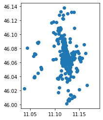
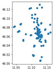
pois_shops.plot()
plt.show()
pois_commerce.plot()
plt.show()
pois_commerce.explore(tooltip=['building'])
pois_commerce_amenities.plot()
plt.show()
pois_commerce_amenities.explore(tooltip=['amenity'])
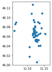
healthcare
healthcare_amenity_values = ["baby_hatch","clinic,dentist","doctors","hospital","nursing_home","pharmacy","social_facility","veterinary"]
pois_healthcare = amenities[amenities.amenity.isin(healthcare_amenity_values)]
pois_healthcare.plot()
plt.show()
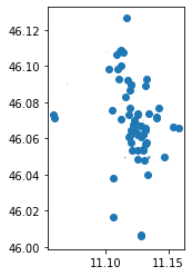
education
education_amenity_values = ["college","driving_school","kindergarten","language_school","library","toy_library","training","music_school","university"]
pois_education = amenities[amenities.amenity.isin(education_amenity_values)]
pois_education.plot()
plt.show()
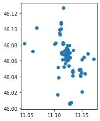
entertainment
entertainment_amenity_values = ["arts_centre","cinema","community_centre","events_venue","fountain","social_facility","gambling","planetarium","public_bookcase","social_centre","studio","theatre"]
pois_entertainment = amenities[amenities.amenity.isin(entertainment_amenity_values)]
pois_entertainment.plot()
plt.show()
living
living_amenity_values = ["courthouse","fire_station","police","post_box","post_office","ranger_station","townhall"]
pois_living = amenities[amenities.amenity.isin(living_amenity_values)]
pois_living.plot()
plt.show()
cross the area
isochrones_student_accomodations = isochrones_student_accomodations.to_crs(epsg=4326)
… you can use different approach
this is made only to repeat some concepts presented in the previous lessons
def checkInsideArea(p,i):
touch = False
try:
touch = p.within(i)
except Exception as e:
print(e)
pass
if touch == False:
return False
else:
return True
names = {}
for idx, row in isochrones_student_accomodations.iterrows():
name = row['name']
label = "student_accomodation_" + str(idx)
names[label] = name
polygon = row.geometry
pois_living[label] = pois_living.geometry.apply(lambda g: checkInsideArea(g,row.geometry))
pois_entertainment[label] = pois_entertainment.geometry.apply(lambda g: checkInsideArea(g,row.geometry))
pois_education[label] = pois_education.geometry.apply(lambda g: checkInsideArea(g,row.geometry))
pois_healthcare[label] = pois_healthcare.geometry.apply(lambda g: checkInsideArea(g,row.geometry))
pois_commerce[label] = pois_commerce.geometry.apply(lambda g: checkInsideArea(g,row.geometry))
pois_shops[label] = pois_healthcare.geometry.apply(lambda g: checkInsideArea(g,row.geometry))
pois_commerce[label] = pois_commerce.geometry.apply(lambda g: checkInsideArea(g,row.geometry))
pois_commerce_amenities[label] = pois_commerce_amenities.geometry.apply(lambda g: checkInsideArea(g,row.geometry))
for name in names:
living_places = pois_living[pois_living[name] == True].shape[0]
entertainment_places = pois_entertainment[pois_entertainment[name] == True].shape[0]
education_places = pois_education[pois_education[name] == True].shape[0]
healthcare_places = pois_healthcare[pois_healthcare[name] == True].shape[0]
commerce_places = pois_commerce[pois_commerce[name] == True].shape[0]
commerce_places += pois_shops[pois_shops[name] == True].shape[0]
commerce_places += pois_commerce_amenities[pois_commerce_amenities[name] == True].shape[0]
total = commerce_places + living_places + education_places + healthcare_places + entertainment_places
print(names[name])
print("living places %s" % living_places)
print("entertainment places %s" % entertainment_places)
print("education places %s" % education_places)
print("healthcare places %s" % healthcare_places)
print("commerce places %s" % commerce_places)
print("TOTAL %s" % total)
print(" ")
Studentato San Bartolameo
living places 0
entertainment places 2
education places 0
healthcare places 0
commerce places 1
TOTAL 3
Collegio Bernardo Clesio
living places 2
entertainment places 1
education places 5
healthcare places 0
commerce places 58
TOTAL 66
Studentato Mayer
living places 3
entertainment places 1
education places 3
healthcare places 1
commerce places 13
TOTAL 21
NEST
living places 1
entertainment places 1
education places 1
healthcare places 0
commerce places 5
TOTAL 8